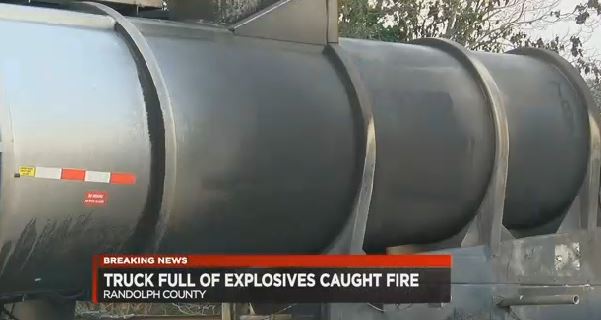
Natural Gas Pipeline Compressor Stations and Major Natural Gas Transportation Corridors
Natural gas pipeline compressor stations, like this one on the
Trailblazer Pipeline in northeastern Colorado, offer strong opportunities for
clean and renewable energy from waste heat recovery.
Natural gas compressor stations using compressors driven by gas
turbines or internal combustion engines offer strong opportunities for waste heat recovery.
Transporting natural gas from producers to consumers requires
an extensive and elaborate distribution system, which consists of a complex
network of pipelines. Compression
stations, usually placed at 40 to 100 mile intervals along the pipeline, are
required to ensure proper pressurization of natural gas. The natural gas enters
the compressor station, where it is compressed by a turbine, or engine. Compressor stations move on average about 700
million cubic feet (MMcf) of natural gas per day, with the largest moving
upwards of 4.6 billion cubic feet (Bcf) per day.
Although natural gas compressor stations vary widely in size
and layout, the basic compressor systems are comprised of two components - the
"mechanical drive" that provides the shaft power that drives the
compressor, and the "compressor" itself. The mechanical drive can be an internal
combustion (IC) engine, gas turbine, or electric motor. The compressor itself can be a reciprocating, centrifugal,
or screw compressor. IC engine and gas turbine drives burn natural gas from the
pipeline. Electric motor drives can be
used on any type of compressor but require reliable electrical power supply.
Source: Energy
Information Administration, Office of Oil & Gas, Natural Gas Division,
Natural Gas Transportation Information System. The EIA has determined that the informational
map displays here do not raise security concerns, based on the application of
the Federal Geographic Data Committee’s Guidelines
for Providing Appropriate Access to Geospatial Data in Response to Security
Concerns.
Facts and Figures
·
More than 210 natural gas pipeline systems.
·
305,000 miles of interstate and intrastate
transmission pipelines
·
More than 1,400 compressor stations that
maintain pressure on the natural gas pipeline network and assure continuous
forward movement of supplies (see map above).
·
More than 11,000 delivery points, 5,000 receipt
points, and 1,400 interconnection points that provide for the transfer of
natural gas throughout the United States.
·
24 hubs or market centers that provide
additional interconnections.
·
400 underground natural gas storage facilities.
·
49 locations where natural gas can be
imported/exported via pipelines.
- 8 LNG (liquefied natural gas) import facilities and 100 LNG
peaking facilities
The national natural gas delivery network is intricate and
expansive, but most of the major transportation routes can be broadly
categorized into 11 distinct corridors or flow patterns.
5 major routes extend from the producing areas of the Southwest
4 routes enter the United States from Canada
2 originate in the Rocky Mountain area.
A summary of the major corridors and links to details about
each corridor are provided below.
Corridors from the Southwest Region
More than 20 of the major interstate pipelines originate in the
Southwest Region. Some extend to the Southeast through Louisiana and Arkansas,
others to the Central and Midwestern States through Texas, Oklahoma, and
Arkansas, and to the Western States through New Mexico. This area of the
country exports about 45 percent (6.1 trillion cubic feet in 2007) of its
production, which is 47 percent of the total natural gas consumed elsewhere in
the lower 48 States.
Pipelines exiting the region have the capacity to accommodate
as much as 45.2 Bcf per day: 62 percent to the Southeast Region, 20
percent to the Central Region, 13 percent to the Western Region, and the rest
to Mexico. Much of the pipeline capacity directed toward the Southeast
traverses the region en route to Midwestern and Northeastern markets. To a
lesser degree, this is also true for the pipeline capacity exiting to the
midsection of the country, much of which is ultimately destined for the
Midwestern States.
1.
Southwest-Southeast:
from the area of East Texas, Louisiana, and the Gulf of Mexico, to the
Southeastern States.
2.
Southwest-Northeast: from the area of East Texas, Louisiana, and the Gulf
of Mexico, to the U.S. Northeast (via the Southeast Region).
3.
Southwest-Midwest: from the area of East Texas, Louisiana, Gulf of Mexico,
and Arkansas to the Midwest.
4.
Southwest Panhandle-Midwest: from the area of southwestern Texas, the Texas
and Oklahoma panhandles, western Arkansas, and southwestern Kansas to the
Midwest.
5.
Southwest-Western: from the area of southwestern Texas (Permian Basin) and
northern New Mexico (San Juan Basin) to the Western States, primarily
California.
6.
Canada-Western: from
the area of Western Canada to Western markets in the United States, principally
California, Oregon, and Washington State.
7.
Canada-Midwest: from the area of Western Canada to Midwestern markets in
the United States.
Corridors From the Rocky Mountain Area
In the Central Region, only two major interstate pipelines
originating within the region provides transportation services directly to
another region, Kern River Transmission Company and the Rockies Express
Pipeline Company. All the others operate primarily within the Central Region
itself or originate in other regions. Shippers using these interregional lines
to move supplies outside the region take advantage of the interconnections
these lines have with the interstate pipelines traversing the region,
principally those coming out of the Southwest Region.
10.
Rocky Mountains-Western: from the Rocky Mountain area of Utah, Colorado,
and Wyoming to the Western States, primarily Nevada and California with support
for markets in Oregon and Washington.
Details about the Transportation Corridors
Southwest to Southeastern US
Two fairly distinct subcorridors extend into the Southeast
Region from the Southwest: one goes eastward into Mississippi and continues
further east, and the second goes northward into Tennessee and Kentucky. Along
the first route, five major interstate pipeline companies -- Centerpoint Energy
Transmission Company, Florida Gas Transmission Company (FGT), Gulf South
Pipeline Company, Gulfstream Natural Gas System, and Southern Natural Gas
Company (SONAT) -- transport the vast majority of natural gas that is delivered
within the Southeast region. Together
they can handle at least 13.3 billion cubic feet (Bcf) per day for shippers in
the region.
Since 2006, several major transmission pipeline expansions have
taken place on this route as expanding natural gas development and production
in the Barnett shale and Bossier formations in east Texas has needed to find
access to new markets. Centerpoint Energy Transmission Company and Gulf South
Pipeline Company have both extended and expanded their mainline systems to
reach interstate pipeline interconnections in Mississippi and Alabama,
increasing capacity along this route by 3.7 Bcf/d. By 2010, three more
interstate pipelines are scheduled to be built along this corridor, adding 4.2
Bcf/d. They are: Texas Gas Transmission Company's 1.1 Bcf/d
Fayetteville/Greenville Laterals, the 1.7 Bcf/d Gulf Crossing Pipeline and the
1.4 Bcf/d MidContinent Express Pipeline.
Varying amounts of capacity on several other large interstate
pipelines that follow this subcorridor also serve limited markets in the
region. For instance, Transcontinental Gas Pipeline Company (Transco) serves
customers in Georgia, South Carolina, and North Carolina as it continues along
its route up the east coast. However, this service only represents about 1.1
Bcf per day, or 30 percent, of the 3.5 Bcf per day found on the Transco
system as it enters the region. Yet, in North Carolina it is essentially the
only source of natural gas supplies to the State.

Along the second subcorridor, one pipeline company Texas Gas
Transmission Company (TGT) predominates, at least in terms of delivery points. While this system extends into
the Midwest Region, more than 70 percent of its delivery points are located in
the States of Kentucky and Tennessee. TGT provides substantial deliveries to
underground storage facilities in northern Kentucky that supplement supplies to
the local market and to the Midwest Region during the heating season.
Tennessee Gas Pipeline Company (Tenneco) and Texas Eastern Transmission
Company (TETCO) are
two additional systems operating along this subcorridor, but most of their
delivery points are outside the Southeast Region. Tenneco, however, is the
principal supplier of gas to two regional interstate pipelines: Enbridge
Pipelines (AlaTenn), mostly operating in northern Alabama, and the East
Tennessee Gas Company (Tennessee and Virginia).
The underground storage facilities located along this corridor
are defined by their location. Those facilities at the corridor's southern end
in Louisiana, Mississippi, and Alabama are mainly high-deliverability salt
storage sites to support shippers and traders who want to acquire supplies for
shipment to market. Of the 11.6 Bcf of daily storage deliverability (withdrawal) available in
the area, 56 percent is from salt cavern sites.
This feature provides shippers using these corridors access to
very flexible storage, which can be used to enhance their deliverability
schedule, avoid transportation imbalances, and support any gas trading or
hedging activities they may wish to engage in. In northwestern Kentucky, along
the western subcorridor, storage facilities are devoted primarily to providing
seasonal supplies. They are supported, for the most part, by deliveries from
the Texas Gas Transmission system. The
majority of the storage in Mississippi and Alabama is available to shippers
using either subcorridor.
Southwest to Northeastern US
The Southwest-to-Northeast corridor consists of two routes. The
first extends from East Texas and Louisiana northeastward through Mississippi,
Tennessee, Kentucky, and parts of Ohio to enter the Northeast Region via West
Virginia or Pennsylvania. The second route begins as the first but then extends
northeastward from Mississippi via the east coast States and enters Virginia
from the south. The principal interstate pipeline systems operating along the
corridor include Tennessee
Gas, Columbia Gulf
Transmission, and
Texas Eastern Transmission on the western segment, and Transcontinental Gas
Pipeline on the eastern segment. These four pipeline companies represent
approximately 10.2 Bcf per day of total corridor capacity, making this corridor
the largest of the major transportation corridors in North America.
During wintertime peak periods, each of the systems is almost
fully utilized. During the summer months, however, usage rates for the pipeline
systems operating along this corridor tend to drop substantially. The principal
factor affecting summertime usage rates on several of these pipeline systems is
the demand for gas to refill underground storage sites in the States of West
Virginia and Pennsylvania, and, to some degree, Ohio and New York as well.
The majority of the more than 190 underground storage sites
located along this corridor are accessible to shippers. At the southwestern
terminus of the corridor, more than 30 sites with a working gas capacity of at
least 624 billion cubic feet and a daily withdrawal capability of 13 Bcf per
day are located within 20 miles of the subject pipeline systems. Most of this
capacity is used by producers, who use it to store short-term excess
production, and by market centers.
This corridor links with some of the most active trading points
located outside the Southwestern production area. One of the most significant
is the Ellisburg-Leidy center in Pennsylvania, which provides interconnections
and transportation services between the pipelines comprising this corridor and
the other major interstate pipelines operating primarily within the Northeast
States. Shippers using the corridor may also utilize the services of several
natural gas market centers to expand their marketing and transportation
options.
Southwest to Midwestern US
The Southwest-to-Midwest corridor extends northward out of East
Texas, Louisiana, and Arkansas (Arkoma Basin production) and generally through
Tennessee/Kentucky into the Midwest Region, although a part of it also travels
through Missouri. The principal interstate pipeline systems operating along
this corridor are: ANR Pipeline Company (ANR), Midwestern Gas Transmission
Company (via Tennessee Gas Pipeline Company), Natural Gas Pipeline Company of
America (NGPL), Texas Gas Transmission Company (TGT), Texas Eastern
Transmission Company (TETCO), and Trunkline Gas Company. Mississippi River Gas
Transmission Pipeline Company also transports gas along this corridor but it
terminates in the St Louis, Missouri, area. Its operations in Illinois are confined
to the area east of St Louis.
The portions of these systems located along this corridor
represent approximately 7.8 Bcf per day, or 28 percent of the total
pipeline capacity feeding into the Midwest Region (27.5 Bcf per day). They also
account for more than 30 percent of the total pipeline capacity exiting this
area of the Southwest.
Little underground storage is located along the midsection of
this corridor. However, shippers have access to significant amounts of storage
at either end. This corridor also links together two major gas trading centers:
the Henry Hub in Louisiana and the Chicago Center in northern Illinois. In
addition, the corridor also includes several natural gas trading (and price
discovery) locations accessible to shippers and traders via the several major
commercial electronic trading systems set up in the United States and Canada.
During the heating season, these markets are actively used by
shippers and other market participants as a way to balance their
receipts/deliveries, for arbitrage between the two markets, and to smooth
market and price fluctuations through hedging.
Southwest Panhandle to Midwestern US
This route is a major link between the Waha area (Permian
Basin) of southwestern Texas and the Chicago area market. It extends from the
West Texas and Oklahoma Panhandle areas northward through the major gas
production fields (including Hugoton and Panhandle) located in southwestern
Kansas, and then northeastward toward the Midwest marketplace. In Nebraska, it
links with another corridor (see Rocky Mountain-Midwest section) bringing
supplies in from the Rocky Mountain areas of Wyoming, Utah, and Colorado.
There are four major interstate pipelines that run along this
corridor: ANR Pipeline Company, Panhandle Eastern Pipeline Company, Northern
Natural Gas Company, and Natural Gas Pipeline Company of America. These four pipelines alone
constitute 67 percent of total pipeline capacity exiting this area. These
pipeline routes, however, represent only about 17 percent of the total
capacity into the Midwest Region. The Trailblazer Pipeline system ties in Rocky
Mountain supplies with an interconnection to Natural Gas Pipeline Company of
America in Nebraska.
Market centers and commercial trading points located in the
Waha and Panhandle area of West Texas serve this transportation corridor at its
apex. At its terminus, shippers and traders can link their Texas trading with
the Chicago market. In addition, trading centers located in south central
Kansas provide shippers with the opportunity to do business with traders in the
other two areas. All four pipelines operating in the corridor have direct or
indirect links with each other.
Only a limited amount of underground storage capacity is
available to transporters along this route. However, during the nonheating
season a sizeable amount of capacity on these systems is used to transport
supplies for injection into storage facilities in Illinois, Indiana, and
Michigan. The ANR
Pipeline system in particular has a number of open-access sites located at the
northern end of its system in Michigan. NGPL has a number of storage sites
located in Illinois.

The Southwest-Western corridor is used to transport supplies
from the Permian Basin area of West Texas, through New Mexico (where the
northern route taps into the San Juan Basin production area), and westward
primarily to Arizona and California. Two major interstate pipelines, El Paso
Natural Gas Company and Transwestern Pipeline Company, operate along this
corridor. Both of these pipelines end at the California or Nevada State
borders, where they deliver supplies to Southwest Gas Company (Nevada),
Southern California Gas Company, and Pacific Gas & Electric Company, the
largest pipelines serving the California marketplace. In addition, Transwestern
Gas Pipeline Company links with the Mojave Pipeline Company, an interstate
pipeline that transports natural gas supplies to the enhanced oil recovery
(EOR) and cogeneration customers located in Kern County, California.
Joining El Paso Natural Gas Company and Transwestern Pipeline
Company along the northern route, in 2002 Questar's Southern Trails Pipeline
(an oil pipeline conversion) was completed, transporting an additional 90 MMcf
per day between the San Juan Basin area and the California border.
Much of the natural gas flowing along this corridor is produced
in the San Juan Basin. The TransColorado Pipeline system, completed in 1996,
can move as much as 590 MMcf per day from north central Colorado and the
Ignacio area of the southern Colorado San Juan Basin to interconnections with
the El Paso Natural Gas and Transwestern Pipeline systems in the Blanco area of
northwestern New Mexico. Northwest Pipeline Company also can deliver up to 250
Mmcf per day into these two systems.
A significant amount of West Texas and New Mexico gas supplies
also are transported along the southern portion of this corridor, which
consists primarily of the El Paso Natural Gas Company's Line 2000 which has a
throughput capacity of approximately 2.4 Bcf per day. This section of the
corridor primarily serves southern Arizona and southern California, but in 2002
it also began service to the new North Baja Pipeline system, designed to
transport up to 500 MMcf per day to Mexico. (In 2010, the North Baja Pipeline
system will become bidirectional, having the capability to transport up to 2.0
Bcf per day from LNG import facilities in Mexico to Western U.S. markets.)
There is very little underground natural gas storage capacity
associated with this corridor. At the extreme eastern end of the corridor, only
one site, the Washington Ranch facility operated by El Paso Natural Gas Company,
is reserved primarily for system support services and is not available for
customer use. At its western end, in southern California, a limited amount of
storage capacity is available to shippers at five sites operated by Southern
California Gas Company (SoCal).
Although some of the natural gas injected into these storage
sites comes from producing fields in southern California, a significant amount
of the working gas stored at these sites comes out of this corridor. The
combined withdrawal rate capability of the four sites is 3.7 billion cubic feet
(Bcf) per day, while their total working gas capacity is 120 Bcf. This
translates into roughly 32 days of backup from these sites.
Western Canada to Midwestern US
This transportation corridor lies between Western Canadian
supply areas and the U.S. Midwest and links two Canadian systems, TransCanada
Pipeline Ltd. and Foothills Pipeline Company, with three United States pipeline
systems, Great Lakes Gas Transmission Company, Northern Border Pipeline Company
and Viking Gas Transmission Company. In addition, the 1,300-mile Alliance
Pipeline, completed in late 2000, provides a direct transportation route for
"wet" (natural gas high in liquids content) between producing fields
in northwestern British Columbia and Alberta, Canada, and a gas-processing
plant (Aux Sable) located outside Chicago, Illinois. These tie-ins represent
about 6.2 Bcf per day of pipeline capacity, or about 41 percent of total U.S.
natural gas import capacity in 2006. Between 1990 and 2006, capacity on this
route more than doubled, going from 3.1 Bcf per day in 1990 to 7.2 Bcf per day
in 2006.
The Northern Border Pipeline (NBP) system extended its pipeline
system to Illinois (from it original terminus in Iowa) in 1998 and to Indiana
in 2001, now providing almost a Bcf per day to the Chicago area and to
customers in Indiana. In 2000, another pipeline, the Vector Pipeline system,
located between Chicago, Illinois and Dawn, Ontario, at the eastern end of the
corridor, was placed in service. It can transport up to one Bcf per day between
the United States (Michigan) and Canada (Ontario). It was developed primarily
to provide an alternative expansion route for Canadian gas and service to
customers in Ontario, Canada. It also lies along a route that can be expanded
to potentially accommodate gas transportation of Western Canadian gas to
Northeast U.S. markets via the Empire/Millennium gas pipeline system that is
scheduled for development in New York State in 2008.
A large number of underground storage facilities are located in
proximity to several of the pipeline systems operating in this corridor,
although not all of them are directly accessible to shippers. For instance,
nine sites (1 Bcf per day injection, 1.8 Bcf per day withdrawal capability) are
directly accessible to shippers using the Great Lakes Gas Transmission system,
while the storage facilities located in Illinois and operated by Northern
Illinois Gas Company (eight sites, 3.4 Bcf working gas capacity) are available
only through the Chicago Market Center, which is affiliated with the company,
or through the company itself. Altogether, the daily injection capability at
storage facilities linked to the receiving end of this corridor represents the
potential use of about five Bcf per day of pipeline capacity during the storage
refill period from April through October.
Western Canada to Northeastern US
The western portion of the Canada-Northeast corridor links the
TransCanada Pipeline system (and Western Canadian gas production) to seven
pipeline companies in the Northeastern United States. The seven are: Iroquois
Pipeline Company, North Country Pipeline Company, the Portland Gas Transmission
System, Tennessee Gas Pipeline Company, Empire Pipeline Company, Vermont Gas
Company, and St. Lawrence Gas Company. Indirectly, the corridor also supplies
gas to the National Fuel Gas Supply Company and Dominion Transmission Company.
The seven systems transport gas primarily into New York and the
New England States at a total capacity level of 3.4 Bcf per day. While the vast
majority of the Canadian capacity that comes into the U.S. Northeast is off the
northern tier of the TransCanada system, about five percent represents capacity
that traverses the U.S. Midwest (on the Great Lakes Transmission system), crosses
back into Canada through Ontario, and is imported once again at Niagara, New
York.
In Canada, at the western end of this corridor in Alberta and
Saskatchewan provinces, approximately 4 Bcf per day of daily storage
deliverability is available at 12 sites interconnected with the TransCanada
Pipeline System. In addition, over 25 storage sites located at Dawn, Ontario,
Canada, are available to shippers transporting supplies to the area via the
Great Lakes Transmission system. In
the U.S. Northeast, storage deliverability of up to 14.8 Bcf per day is
available to these shippers.
Eastern Canada to Northeast (New England)
This corridor consists primarily of the Maritimes and Northeast
Pipeline system, completed in late 1999. It can transport more than 445 MMcf
per day into the United States from off the eastern coast of Canada at Sable
Island. The current system merges with the Portland Gas Transmission System at
Wells, Maine to deliver almost 628 MMcf per day in northern Massachusetts to
customers on the Tennessee Gas Pipeline system. Beginning in 2002, with the
completion of Phase III of the Maritimes and Northeast Pipeline system,
shippers have had the option of transporting up to 230 MMcf per day of this
capacity to the Boston, Massachusetts area on the system.

The Canada-Western route brings natural gas from Alberta and
British Columbia, Canada, through the States of Washington, Idaho, and Oregon,
with terminating points in Nevada and California. In Canada, Spectra Energy
Corporation's Westcoast Gas Transmission Ltd. and Alberta
Natural Gas Ltd. (in association with Foothills Pipeline Ltd.) receive gas from
the TransCanada Pipeline (NOVA) in Alberta (the principal pipeline system in
the region linked into the major production areas in Alberta and British
Columbia) and transport that gas to the U.S. border. There the supplies are
received by Northwest Pipeline Company (from Westcoast Gas Transmission) and
Gas Transmission Northwest from Alberta Natural Gas. The two pipelines have a
combined capacity of 4.4 Bcf per day, 99 percent of import capacity in the
area. This route represents one-quarter of the total capacity reaching the
United States from Canada.
While the Gas Transmission Northwest Company transports most of
its gas, about 76 percent in 2006, directly southward to California, the
Northwest Pipeline Company system extends south and eastward from its border
receipt point, operating on a bidirectional basis along much of the eastern
section. At the
northern Nevada State line, Northwest Pipeline Company links with the Paiute
Pipeline Company, which until recently was the only gas supplier to the Reno,
Nevada, area. Only one new pipeline has been added to the corridor since 1990,
the Tuscarora Pipeline Company (110 MMcf per day) in 1995. This pipeline
interconnects with the Gas Transmission Northwest Company system at the
northern California border and transports gas to the Reno, Nevada area.
Access to underground storage for shippers along this corridor
is limited. Much of the storage capacity on the southern portion is owned and
operated by local distribution companies and is used exclusively to support
their own seasonal storage needs. Nevertheless, shippers can acquire access to
storage services on an as-available basis through several independent storage
operations. The California Gas Transmission Company provides limited access to
its three storage sites in northern California. At the Canadian end of the
corridor, much of the available storage is intricately linked with market center
operations, providing parking and loaning services primarily to producers
shipping gas to the United States. These Canadian sites are capable of handling
up to 6 Bcf per day deliverability and have a working gas capacity level of
about 412 Bcf.
Rocky Mountain Area to Western US
This system extends from the Opal, Wyoming area southwestward
through Nevada, just north of Las Vegas, to Kern County, California. In
California, the Kern River Pipeline system physically merges with the Mojave
Pipeline system (400 MMcf per day) to form one line serving customers primarily
in Kern and San Bernardino Counties in California. Mojave receives its supplies
from Transwestern Gas Pipeline Company and El Paso Natural Gas Company at the
Arizona-California border. Its capacity is approximately 885 million cubic
feet per day.
The Kern River Pipeline system was developed primarily to carry
gas to the enhanced oil recovery market in southern California, which has been
a large natural gas market. In 1997, its service was extended to the Las Vegas
electric power generation market with the opening of an expanded metering
facility with Southwest Gas Company, the major natural gas distributor in the
Las Vegas area. Its system capacity was doubled in 2003 to approximately 1,750
MMcf/d to accommodate the growing demand along its route.
Underground storage facilities, although available at the apex
of this corridor in Wyoming and Utah, do not play a major role in the
operations of the Kern River Pipeline system. Although six sites are in the
vicinity, with a combined daily deliverability of 0.7 Bcf per day and 57 Bcf of
working gas capacity, only one, Questar Pipeline Company's Clay Basin facility
(0.4 Bcf per day, 51 Bcf), is accessible to shippers.
Rocky Mountain Area to Midwestern US
This corridor links Rocky Mountain natural gas supplies from
Utah, Wyoming, and Colorado with markets in the Midwestern United States and
with several sizable metropolitan markets in eastern Kansas and Missouri. While
the corridor itself does not yet extend into the Midwest, the several pipelines
currently operating along this route interconnect with major trunklines that
bring natural gas supplies from the Southwest Region to Midwestern markets.
The Trailblazer System, which is a contiguous linkup of the Overthrust,
Wyoming Interstate, and
Trailblazer pipelines, operates from western Wyoming to eastern Nebraska, where
it offloads to the Natural Gas Pipeline Company of America pipeline. Similarly,
Colorado Interstate Pipeline Company ’s Cheyenne Plains Pipeline, built in
2004, provides more than 730 MMcf/d of gas transportation for Wyoming and
Colorado production from the Cheyenne Hub located in northeastern Colorado. The Cheyenne Plains Pipeline
terminates with interconnections to Northern Natural Gas and Natural Gas
Pipeline Company of America in southwestern Kansas. Natural gas transported on
these pipeline systems is subsequently delivered to customers in the eastern
portion of the Central Region and in Midwestern markets.
The Southern Star Central Pipeline (formerly Williams Natural Gas
Co – Central) and the KM Interstate Pipeline Company also have operations along
this corridor, but these two pipelines serve primarily local regional markets.
However, the KM Interstate Pipeline Company system does include its Pony
Express Pipeline (255 million cubic feet per day) segment which runs from
central Wyoming to south of Kansas City, Missouri. Currently this segment does
not provide any interconnections with the two major interstate pipelines
connecting this corridor to Midwestern markets; rather, its full capacity is
committed to customers located in the Kansas City area.

In 2008, the second segment of the 1.8 Bcf/d Rockies Express
Pipeline system, which will eventually comprise more than 1,660 miles and
transport Rocky Mountain natural gas to Midwest and Northeast markets, was
placed in service. The first segment of the new system, completed in early
2007, involved the construction of a 327-mile pipeline system from the Meeker
Hub in Rio Blanco County, Colorado, to the Cheyenne Hub in Weld County, in
northeastern Colorado. Completion of the entire system, which is scheduled for
early 2010, will mark the first time that Rocky Mountain natural gas supplies
would be delivered directly to Midwest and Northeast markets.
Customers using this corridor have a limited number of
underground storage facilities available for their use. At the terminus of the
corridor in Wyoming and Colorado are 18 sites that customers may access. Much
of the storage located at this end, however, is used to support local producers
and distribution companies. In the Chicago area corridor, shippers also have
access to several storage facilities associated with the Chicago market center.

Metropolitan
Engineering, Consulting & Forensics (MECF)
Providing
Competent, Expert and Objective Investigative Engineering and Consulting
Services
P.O.
Box 520
Tenafly,
NJ 07670-0520
Tel.:
(973) 897-8162
Fax:
(973) 810-0440
We are happy to
announce the launch of our twitter account. Please make sure to follow us at
@MetropForensics or @metroforensics
Metropolitan
appreciates your business.
Feel
free to recommend our services to your friends and colleagues.
To unsubscribe from
future technical blogs and announcements, please reply to this email with the
word “unsubscribe” in the subject line.