MEC&F Expert Engineers : 02/26/17

Sunday, February 26, 2017

A male driver killed and a woman was rescued after their car fell in Saugatuck River from a boat launch in Westport, Connecticut


WESTPORT, Connecticut (WABC) -- Authorities say a man was killed and a woman was rescued after their car ended up in a Connecticut river.


Police have identified the man who died after a car plunged into the Saugatuck River Saturday night.


Police said Richard Lamendola, 76 of Syosset, New York was pulled from the water and taken to Norwalk Hospital where he was pronounced dead

An unidentified woman was rescued from the crash and taken to Norwalk Hospital. The woman was cold from being in the water but probably will be OK, police said.

Police said they believe the car went entered the Saugatuck River from the state boat launch on Elaine Road. No foul play is suspected, Lt. David Farrell said.


About 7:40 p.m, the woman's screams alerted diners at the Whelk Restaurant on Riverside Avenue, just north of the I-95 overpass. The patrons called 911, and emergency responders located the woman in the middle of the river being carried north by the current, Farrell said.

She told rescuers that a man who had been with her in car was still in the river. Authorities found him a half hour later by the Bridge Street bridge, north of the restaurant.

He said the first rescuers to the scene got onto the river quickly by boarding a civilian boat on the side of the river. "It was quick thinking," he said.

He said the investigation is continuing. Westport police officers and firefighters responded immediately, were assisted by state police, Norwalk police and Fairfield police. The Westport Dive Team was on the scene Saturday night to help remove the vehicle from the river.


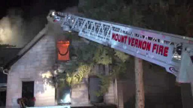
A woman and her infant daughter were killed when flames tore through their home in Mount Vernon, New York


By Kristin Thorne
Updated 1 hr 59 mins ago
MOUNT VERNON, New York (WABC) -- A woman and her infant daughter were killed when flames tore through their home in Mount Vernon early Sunday.

The fire broke out at about 3:30 a.m. at the home on South 13th Avenue and raced through the top levels.

The fire chief says there was heavy fire on the second floor when firefighters arrived.

Nina Bryant, who was in her early thirties, and her daughter Nadia Bryant, aged 17 months, died in the fire.

One other person was transported to Montefiore Hospital with non-life threatening injuries.


Bryant's two young sons sleeping on the first floor were able to get out safely, her husband said.

The Mount Vernon Fire Department was assisted by the New Rochelle, Pelham, and Eastchester Fire Department. Over 35 firefighters responded to the scene.

The mayor of Mount Vernon says a family of 11 people lived in the home.

"We had reports of occupants still inside the building," said Mount Vernon Fire Chief Al Everett. "We recovered the infant at 4:58, and several minutes later we recovered the young adult."

"This is a situation that no family should ever be greeted with," said Mount Vernon Mayor Richard Thomas. "The family right now is obviously in a lot of pain and grief. The city of Mount Vernon is standing with them. And our firefighters who responded to the scene, the police officers are also impacted because this could have been their family too."

The Red Cross has responded to the scene.

2 persons killed, one injured after a private Navion F aircraft crashed into trees while practicing takeoffs and landings at Gabreski Airport in Suffolk County.


A small plane with three people on board crashed Sunday morning at Gabreski Airport in Suffolk County.

Authorities say two people were killed and another is hospitalized.

The private Navion F aircraft crashed into trees while practicing takeoffs and landings at about 11:40 a.m., according to the FAA.

The identities of the victims have not yet been released.

The FAA is en route to the scene.

The National Transportation Safety Board is investigating the crash.

The airport is used by corporations and private plane owners, as well as the 106th Rescue Wing of the Air National Guard. It was built by the federal government in 1943.


Date:

26-FEB-2017
Time:10.40 a.m.
Type:Silhouette image of generic NAVI model; specific model in this crash may look slightly different
Navion F
Owner/operator:Private
Registration:
C/n / msn:
Fatalities:Fatalities: 2 / Occupants: 3
Other fatalities:0
Airplane damage: Written off (damaged beyond repair)
Location:near Gabreski airport -   United States of America
Phase: Unknown
Nature:Private
Departure airport:
Destination airport:
Narrative:
The plane crashed into some trees while practising takeoffs and landings. Two occupants died, a third was seriously injured.
Sources:

www.nbcnewyork.com 
http://abc7ny.com/news/2-dead-1-injured-after-small-plane-crashes-at-suffolk-county-airport/1774152/

WHEN YOU BUILD HOMES IN FLOODPLAINS, DO NOT COMPLAIN ABOUT FLOODING: The Coyote Creek Flooding in San Hose, CA


San Jose floods: City’s failure to raise alarm contrasts response to crisis at Oroville Dam


By Julia Prodis Sulek | jsulek@bayareanewsgroup.com and Matthias Gafni | mgafni@bayareanewsgroup.com |
PUBLISHED: February 26, 2017 at 5:00 am | UPDATED: February 26, 2017 at 8:03 am

When the Oroville Dam’s emergency spillway began to crumble earlier this month, phones throughout the region started blasting with emergency alerts, even sending shoppers at the local Wal-Mart to abandon their carts and flee.

When Coyote Creek in San Jose burst over its banks just over a week later, the first warnings for many residents that floodwaters were rising to their windowsills were rescue crews in boats knocking on their doors.

Now, as residents from three San Jose neighborhoods and two mobile home parks lament all they’ve lost and clean up from Tuesday’s flood, they are demanding to know why the city didn’t do enough to raise the alarm.

“I felt like Chicken Little,’’ said Jeff Hare, who saw his Naglee Park neighborhood flood two decades ago and had spent last weekend going door-to-door to warn his neighbors about the rising creek. He even stopped by a nearby fire station and called the water district to ask if they were truly prepared.

Authorities near the Oroville Dam faced criticism for a chaotic evacuation of nearly 200,000 people fleeing a wall of water that never came, but San Jose’s leaders are under fire for leaving so many residents unprepared for the city’s worst flooding in 20 years.

No lives were lost in either crisis, but the indecision and communications breakdown among city and water district officials in San Jose are raising questions about how authorities here prepared for and responded to an emergency that unfolded over two days last week.

“The public deserves to know all of the facts about why there was not sufficient warning to residents,” Mayor Sam Liccardo acknowledged Saturday. He will be holding a hearing in the next two weeks for a full public vetting. “There will not be any information held back.”

So far, however, city officials have few answers. On Monday, a day ahead of the flooding, the city and the Santa Clara Valley Water District posted information on social media sites, including Twitter, Facebook and Next Door, about the possibility of flooding and that they had opened an overnight shelter for those who wanted to get to higher ground. San Jose Mayor Sam Liccardo talks with Red Cross volunteer Mo Ghandehari, right, at the overnight shelter for the flood evacuees at James Lick High School Gymnasium in San Jose on Tuesday. (Josie Lepe/Bay Area News Group)

Those efforts got little traction in Rock Springs, a neighborhood near Happy Hollow Park & Zoo, where many residents living in the small apartment units speak primarily Spanish or Vietnamese. By Tuesday night, city officials had ordered about 14,000 residents to evacuate, but not until hours after floodwaters had already filled many homes.


San Jose has no universal alert system of its own — like a “reverse 911” that automatically calls and texts people about nearby emergencies. Santa Clara County has been working to tap into a warning system run by the Federal Emergency Management Agency, but it still hasn’t been activated. So as the flooding worsened, the country’s 10th largest city relied on the county’s emergency alert system that requires residents to log onto the county website and register to get warnings. However, even that system didn’t appear to work. Liccardo said that while some subscribers received “multiple alerts,” many said they received nothing.


Not only did communication fail between the city and potential flood victims, it also broke down between the city and the water district, which was monitoring Coyote Creek for flooding risks.

Both agencies, along with the National Weather Service, county emergency services and others, participated in numerous conference calls in the week before the flood, as the Anderson Reservoir, which feeds the creek in Morgan Hill, began spilling over for the first time in 11 years.

After water began rising faster than anticipated early Tuesday morning following Monday’s major storm, a water district official warned the city’s emergency operations center in a 2:47 a.m. email that the rate of the creek flow at a flood gauge south of the city was climbing “a little earlier than previously predicted.”

“That means that amount could reach, for example, the Rock Springs neighborhood about 6-7 a.m.,” the water district’s Jim McCann wrote. The Red Cross shelter began filling up with flood evacuees on Wednesday in the gymnasium at James Lick High School in San Jose. (Jim Gensheimer/Bay Area News Group)

But residents never received that alert. Finger pointing In the aftermath of the flooding didn’t take long: Water district officials said it was their job to inform the city of flood risks, not decide how and when to alert residents. But city officials were quick to question the water district’s data and level of urgency as the conditions changed overnight.

“That same information should have been conveyed by phone if it was that serious,” said city spokesman David Vossbrink.


Even interoffice communications were strained. An hour after flooding was 4 feet deep in the Rock Springs neighborhood, one of Liccardo’s staff members, Alex Wilson, sent him a note that water district officials “advised we keep a close eye on the Rock Spring neighborhood, but models don’t predict it will flood until” the creek flow rate increased.

“Alex,” Liccardo wrote in an email at 1:42 p.m., “Rock Spring started flooding three hours ago. They’re all wrong.”

The National Weather Service in Monterey appeared to have it right. On Feb. 18 — three days before the flooding — it issued a “flood watch.” It followed with a more serious “flood warning” at 3:53 a.m. Monday — sending alerts to phones from Anderson Dam to the bay nearly a full day before the Rock Springs neighborhood near Kelley Park was inundated. The purpose was to alert not only residents along the 20-mile corridor, but emergency management officials as well.

“No model is perfect, but in this case it was kind of a no-brainer,” said Mark Strudley, a weather service hydrologist. “It was a sufficient amount of runoff and rainfall that pretty much everyone knew it was going to flood, but we didn’t have the exact timing of when the flooding was going to start or the magnitude.” A rescuer gives a resident a piggyback escort out of a San Jose neighborhood flooded Tuesday morning near Coyote Creek. (Robert Salonga, Bay Area News Group).

Some heeded the warning. Crews walked through creekside homeless encampments the weekend before the floods urging people to move. Still, three homeless people found themselves stranded Monday, and by 7 a.m. Tuesday morning, rescuers plucked five people clinging to the trees in the swollen creek at the Los Lagos Golf Course.

With no alerts or sirens, the Rock Springs neighborhood was caught by surprise when flooding began a couple of miles downstream. By 9:39 a.m., a dispatcher was telling a firefighter: “The entire neighborhood is under water about 3 to 4 feet.” By about 10 a.m., with cars under water and apartments flooding, firefighters were rescuing more than 100 people by boat.

Farther downstream, in the upscale, historic neighborhood of Naglee Park that flooded in 1997 just east of downtown, many residents had been following the social media posts from the city and the water district.

Hare, the “Chicken Little” of the neighborhood who helps Boy Scouts earn their merit badges in emergency preparedness, had been closely monitoring Coyote Creek online.

“My feeling here is that the water district did not manage this situation as well as it should,” he said, “and the city’s response really fell short.”

That left the neighbors he hadn’t reached still believing that the flooding would be no worse than in 1997. Down the block, Sandra Moll’s indoor furniture ended up floating into her garden.

“I could have gotten my neighbors to move all my furniture upstairs,” she said. “We could have gotten more sandbags and stacked them even higher. I could have done all kinds of things.” The extensive flooding Tuesday along East William Street and William Street Park in San Jose. (Courtesy Kevin Lowe).

On the east side of the creek near Olinder School, water was waist-high by 4:30 p.m. Tuesday, but no one was ordered to leave until fire trucks came through, blasting evacuation orders from loud speakers five hours later. It was closer to 10:30 p.m. when some 14,000 residents were placed under a mandatory evacuation order in that area that stretched to Highway 101.

“If I had any notification, I would have been able to prepare more,” said Alex Maestre, whose black Labrador, Tank, woke him up when the water started filling his patio and driveway. “I would have got a pump and sandbagged both sides of my street. I lost all three of my cars. They’re all salvaged out because the water came over the dash.”

Other Bay Area communities have struggled with emergency warning systems.

Following a massive Aug. 2, 2012, Chevron refinery fire in Richmond that sent more than 5,700 residents to seek medical treatment, residents and politicians blasted the Contra Costa County warning system. Some residents within a mile of the refinery didn’t receive a warning phone call until three hours after the county was notified about the incident by the refinery.

“It’s an absolute disaster,” Councilman Tom Butt, now mayor, said at the time. “It’s never functioned properly.’’

The city of San Jose already knew it needed to upgrade its emergency warning systems. In January, a vendor was invited to demonstrate a mobile speaker system mounted on a trailer that could send messages in seven languages clearly enough to be heard for two miles.

It wasn’t all that different from the sirens used in Oroville.

When the waters receded and most of the residents returned home Thursday and Friday, Liccardo was left to contemplate the missteps and miscommunication. Cleaning up the mess — in the flooded neighborhoods and at City Hall — will be difficult.

“I’ve been explicit from the very start of this that there were failures — and failures we should never repeat,” Liccardo said. “I will take responsibility for ensuring that we do not put our residents in peril again.”


===============


Herhold: Coyote Creek flood echoes San Jose’s past
Coyote Creek is the poor brother of the Guadalupe River, which runs through downtown.


Courtesy Kevin Lowe - A still photo captured from a drone video depicts the extensive flooding which enveloped East Williams Street and William Street Park, at left, in San Jose, Calif. on Tuesday, Feb. 21, 2017.

By Scott Herhold | sherhold@bayareanewsgroup.com |
PUBLISHED: February 26, 2017 at 6:43 am | UPDATED: February 26, 2017 at 8:11 am

Twenty years ago, the Coyote Creek in San Jose became almost the same kind of angry torrent that it did last Tuesday. The water overflowed its banks, ravaging homes in the Rock Springs and Naglee Park neighborhoods. At least 25 apartment buildings suffered severe flood damage.
 

The Santa Clara Valley Water District and the city of San Jose realized they had a problem. The Rock Springs neighborhood is located on the downhill side of a sharp bend in the creek south of Happy Hollow Zoo. And Naglee Park homes back up to the stream.

Coyote Creek is the poor brother of the Guadalupe River, which runs through downtown. It got no serious help from the San Jose Redevelopment Agency, which helped fund flood control work near the arena. Except for Naglee Park, it floods in more modest neighborhoods.

When the waters crested on Tuesday, the water district was still planning work in the Coyote watershed. A major project of flood control work is scheduled between Montague Expressway and Highway 280. But district documents show the project is on hold until next year.

We’re now having an argument over who should have been responsible for warning residents of the flood: An email from a water district official around 3 a.m. Tuesday arguably did not convey the full danger to city officials. And people were understandably upset about being warned to evacuate immediately. It could have been much, much worse.

But there is another facet to this story, one that involves water district priorities, the difficulty of taming the Coyote, and city development policies. As we debate the early morning back-and-forth, we ought to consider these headier topics too. They set the stage for the emergency.

The voters have twice approved a parcel tax for the Golden Spigot — my nickname for the water district — that includes flood control work countywide: the “Safe Clean Creeks’’ measure of 2000 and the “Safe, Clean Water’’ measure of 2012.

But major flood projects take years to plan and complete. They are often controversial. By the late 1990s, the water district had already spent $60 million on flood control work on the Coyote downstream from Montague.

I couldn’t get district officials to explain immediately why the Montague-to-280 project has been postponed until 2018. But a look through the district’s priority list shows that portion of the Coyote is dwarfed by the need to retrofit Anderson Dam, which controls the Coyote’s flow.

The Rock Springs neighborhood is farther down the list. A district pamphlet prepared for the 2012 “Safe, Clean Water’’ measure said more money for planning would leave the district “well-positioned to apply for future grants/and or partnerships’’ to complete flood control work there. Put another way, there wasn’t immediate money reserved for the job.

The city is not immune from criticism, either: Over the years, San Jose has allowed development in areas that have typically been outlets for floodwaters, like the new housing east of the Coyote Creek and south of San Antonio Street, where residents were evacuated last week.

These homeowners typically have to have federally mandated flood insurance. When the carports or lower levels of their homes are damaged, the taxpayers pick up part of the bill. And the new development puts more pressure on the water district to do flood work.

“The water district kind of sits back and watches this liability grow,’’ says Pat Ferraro, a former water district director. “It’s hard for them to move forward at the speed of innovation.’’

The takeaway? Pay attention to the immediate needs, yes. Help those in distress. But ask the longer questions, too. If not, we’re condemned to see the same thing in another 20 years.

Roof damage, downed trees, and downed power lines after storms rolled through the Midstate Pennsylvania Saturday, strongly hitting York, Lebanon, and Lancaster counties.


HARRISBURG, Pa. (WHTM) – Severe storms rolled through the Midstate Saturday, strongly hitting York, Lebanon, and Lancaster counties.

Viewers sent in pictures of roof damage, downed trees, and downed power lines after the storms cleared up. National Weather Service is reporting quarter-sized hail in York and Lancaster counties.

So far, there are no reports of injuries.

There was a report of a funnel cloud north of Columbia. Wind gusts reached 71 miles per hour in Lititz.

Thousands of people have been experiencing outages as a result of the storms. PPL Electric tweeted that it is calling in additional field employees and contractors to work through the night to restore power. Those employees are expecting to continue making repairs late into Sunday.


Thunderstorms and strong winds left thousands of utility customers without power and caused damage around New Jersey Saturday night.


February 25, 2017


Thunderstorms and strong winds left thousands of utility customers without power and caused damage around New Jersey Saturday night.


In Sussex County, Jersey Central Power & Light reported 4,873 customers were without electricity as of around 7:30 p.m. The majority of the outages were in Stillwater Township, Vernon, Wantage and Hampton, according to the utility company's website.

Scott Takac, a Jersey Central Power & Light spokesman, said crews were working to restore service but there was no immediate estimate available on when repairs would be completed.

"We'll have crews working until power is restored," the spokesman said Saturday night. He asked anyone who encounters downed wires to call the company at 1-888-544-4877.

Outages were largely caused by tree limbs hitting wires, he added. There were no immediate reports of damage to the electricity company's substations.

The JCP&L website also reported 2,188 customers without service in Warren County. PSE&G's outage map showed scattered outages in its service area.

Trees were downed across the state as winds and rain moved through the region, according to officials.

At least one structure at Space Farms Zoo and Museum in Sussex appeared to have major damage from the storm, according to photos shared on Twitter.

Jill Space, who runs the family business, said in a Twitter post that all animals were safe at the facility.

"...all animals are fine. We will start the clean up tomorrow," Space said via Twitter.

The National Weather Service reported a tree down on Route 94 in Frelinghuysen Township in Warren County at 4:55 p.m. and trees down in the city of Salem in Salem County about 4:55 p.m.

Forecasters also reported a storm gust of 55 mph in Blairstown in Warren County at 4:54 pm, a storm gust of 58 mph in Wantage in Sussex County at 5:14 p.m. and a storm gust of 60 mph in Turnersville in Gloucester County at 5:20 p.m.