Weather disasters cost U.S. record $306 billion in 2017: NOAA
Blake Brittain
WASHINGTON (Reuters) - Weather and climate-related disasters cost the United States a record $306 billion in 2017, the third-warmest year on record, the U.S. National Oceanic and Atmospheric Administration said on Monday.
The federal agency’s report underscores the economic risks of such disasters even as President Donald Trump’s administration casts doubts on their causes and has started withdrawing the United States from a global pact to combat climate change.
The agency said western wildfires and hurricanes Harvey, Maria and Irma contributed to making 2017 the costliest year on record. The previous record was $215 billion in 2005, when hurricanes Katrina, Wilma and Rita slammed the U.S. Gulf Coast.
Meanwhile, the average annual temperature for the contiguous United States was 54.6 degrees Fahrenheit (12.6 degrees Celsius) in 2017, 2.6 degrees Fahrenheit above the 20th-century average and the third-warmest since recordkeeping began in 1895, following 2012 and 2016, the agency said.
“Natural disasters have caused a record-setting amount of damage in the U.S. this year,” Democratic Senator Dick Durbin of Illinois tweeted in response to the report. “There’s no denying that climate change will cost the U.S. trillions more in the next decade and that we have a financial and national security reason to act.”
Scientists have long concluded that carbon dioxide and other emissions from fossil fuels and industry are driving climate change, leading to floods, droughts and more-frequent powerful storms.
Trump, a Republican, has promised to boost U.S. oil, gas and coal production.
==================
The year 2017 was the third-warmest on record for the United States, and featured a pileup of weather and climate disasters that cost the nation a record-breaking $306 billion, according to the National Oceanic and Atmospheric Administration.
The preliminary data released by NOAA's National Centers for Environmental Information serve as another indication that climate change shows little sign of relenting — with troubling implications for the risk of extreme weather and climate events in the future.
"Clearly, 2017 underscores what we've seen in the past with regard to better mitigating our risk and enhanced frequency of weather and climate extremes," Adam Smith, an applied climatologist at NOAA, said at a briefing Monday.
Here are some highlights from the new NOAA report.
Temperature
The results put annual average temperatures for the Lower 48 states at 54.6 degrees Fahrenheit, 2.6 degrees higher than the average for the 20th century. That places 2017 in the middle of the nation's top-five hottest years since record-keeping began in 1895. All five top years — including the country's warmest, 2016 — have taken place since 2006.
With heat hitting parts of the Southwest, the southern Plains and the Southeast, several individual states saw their highest-ever annual temperatures: Arizona, New Mexico, Georgia, North Carolina and South Carolina. Thirty-two states, including Alaska, had annual temperatures that ranked in their top-10 warmest. Some areas, such as part of the interior Northwest, saw below-average temperatures.
"Not everywhere was warm, but when we do average those temperatures across the entire U.S., it ranked as the third-warmest on record," Jake Crouch, a NOAA climate scientist, said at the briefing. In fact, every state in the lower 48 plus Alaska had above-average annual temperatures for the third year in a row.
Last year also marks the 21st year in a row that the average annual temperature has been higher than the 1901-2000 average, Crouch said.
Extremes
The year 2017 also included 16 weather and climate disasters with losses exceeding $1 billion each — two inland floods, one freeze event, eight severe storms, three tropical cyclones, as well as drought and wildfire, Smith said.
Keep in mind, the average annual number of events from 1980 to 2017 was just 5.8 per year, and the annual average for the most recent five years (that is, 2013 to 2017) was 11.6 events. Climate scientists have long suggested that climate change may lead to a higher risk of certain extreme weather and climate events.
While those 16 "billion-dollar" events tied 2017 with 2011 for the highest number in a single year, 2017 was by far the most expensive, racking up total costs of $306.2 billion. The new record far outpaced the previous record cost of $214.8 billion in 2005, a year that suffered hurricanes Rita, Wilma, Dennis and Katrina. In fact, 2017 was a record year for hurricane costs alone — some $265 billion in losses out of the total $306 billion. Those included hurricanes Harvey, Irma and Maria, which joined hurricanes Sandy (2012) and Katrina (2005) as the top-five costliest hurricanes in U.S. history.
Regional highlights
Last year was also the most expensive wildfire season, with a price tag of $18 billion, Smith said, tripling the cost of the previous wildfire record from 1991. Those numbers include the massive Northern California fires this past fall as well as the blazes that burned through Southern California in December.
Last year was also the country's 20th wettest on record, as well as the fifth year in a row that had above-average precipitation. The year started with a very wet winter for the Northwest, but ended with the ninth-driest December on record. This helped lay the deadly groundwork for the fires that scarred California, the scientists pointed out.
"The really wet winter there allowed vegetation to flourish, and then during the typically dry summer and autumn period that vegetation dried out — providing ample fuels for wildfires," Crouch said. "It's been a pretty devastating year out West, in that respect."
What's to blame
The scientists could not say how much of the high costs of this year's major disasters was due to risks associated specifically with global warming and climate change, and how much was due to the fact that humans tend to live in cities and build vital infrastructure along coasts, rivers and other high-risk zones.
"Both the economists and the physical scientists retrospectively will look at that," said Deke Arndt, chief of the monitoring section for NOAA's National Centers for Environmental Information. "But those kind of happen at the speed of science."
Monday, January 08, 2018 06:24PM
Officials have ordered thousands of people who were affected by recent wildfires in Southern California to evacuate as an upcoming winter storm poses a threat for mudslides and flash floods.
Mandatory evacuations were issued for about 7,000 people in mountainous areas affected by the Thomas, Whitter, Sherpa and Rey fires, according to the Santa Barbara County Office of Emergency Management. Another 23,000 people were under evacuation warnings, officials said.
The storm is the West Coast's first significant winter storm of the season, and heavy rain and strong winds are expected in the area through Tuesday, bringing "strong potential" for flash flooding and mud in areas where wildfires recently burned through, according to Santa Barbara County officials.
Down the coast, the Los Angeles County Sheriff's Department has issued mandatory evacuations for several neighborhoods, including Kagel Canyon, Lopez Canyon and Little Tujunga Canyon, which were all affected by the Creek fire last month.
Flash flood watches are in effect from Los Angeles to Santa Barbara County, and a wind advisory is in effect for the San Francisco area, according to the National Weather Service.
High wind warnings have also been issued for parts of the Bay Area, which could experience wind gusts of up to 60 mph. Winter storm warnings are in effect for parts of the Sierra Mountains and down Southern California to the mountains of San Bernardino and San Diego counties.
The bulk of the rain in Southern California will fall early Tuesday and into the afternoon. The showers are expected to clear by Tuesday night.
Further east, a new storm system is set to bring snow, sleet and freezing rain to parts of the Midwest and East today, meteorologists said.
Despite a break from the record-setting cold, the National Weather Service has issued winter weather advisories for parts of those regions, warning that icy weather could create slippery road conditions.
The storm could bring 1 to 3 inches of snow to some parts of Michigan, Ohio, Pennsylvania, New York and New England, meteorologists said.
To the south, an icy mix could bring a glaze of ice to eastern Kentucky, Tennessee and northern Georgia.
In Atlanta, which typically avoids freezing weather, the National Weather Service said residents had begun to report "slick spots" in areas where light freezing rain began to fall earlier today. Total ice accumulations of less than one-tenth of an inch were predicted.
Parts of Interstate 75 were shut down in northern Georgia because of crashes and icy roads, which apparently contributed to a major pileup the Varnell Police Department tweeted about this morning.
The weather has caused airports to cancel and reschedule flights.
Major carriers like Delta, American and United offered waivers for passengers affected by the backlog.
The storm is not forecast to be a major one, but it could cause hazardous and difficult travel conditions in parts of the Midwest and East, the National Weather Service said.
=====================
Jan 9 2018, 11:19 pm ET
Deadly rains in Southern California send rivers of mud into homes, trigger fire, flooding
by Tom Piozet and Erik Ortiz
MONTECITO, Calif. — Chaos swept across California's Santa Barbara County on Tuesday after a powerful overnight storm hammered the region with heavy rains, leading to the deaths of at least 13 people — and a dramatic rescue of a girl pinned by debris, authorities said.
Santa Barbara County Sheriff Bill Brown called it "a very somber day," and said the 13 deaths were due to the storm.
"While we hope it will not, we expect that this number will increase as we continue to look for people who are still missing and unaccounted for," Brown said.
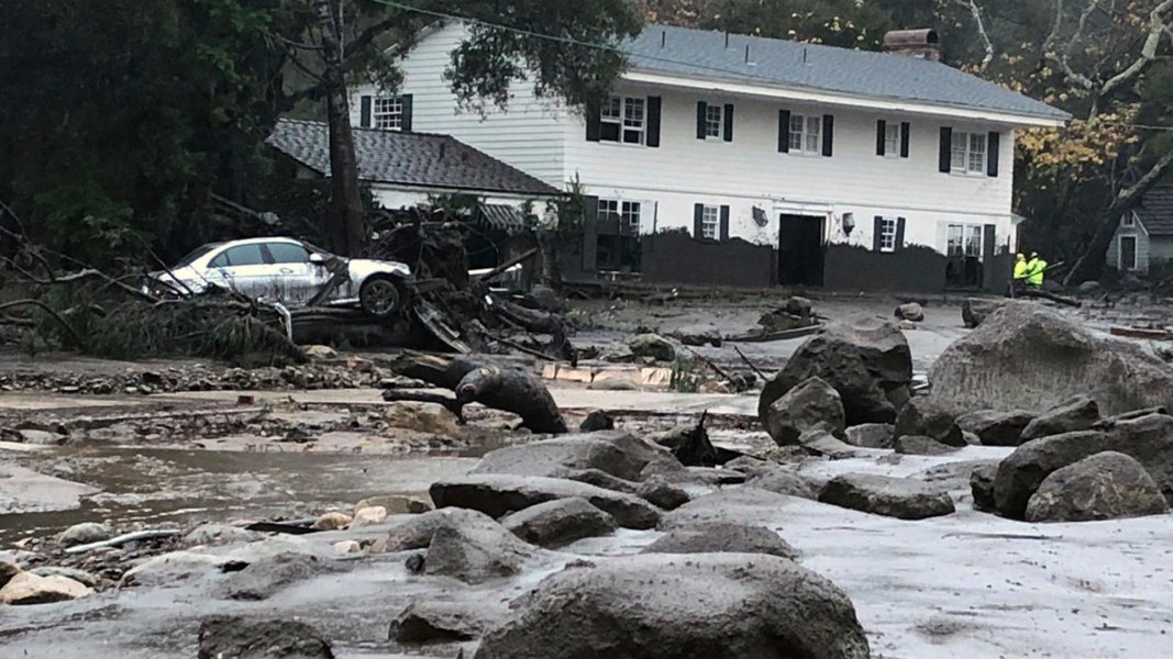
Among the hardest hit areas was Montecito, a wealthy community sandwiched between the Pacific Ocean to the south and the Santa Ynez Mountains to the north, where "massive" runoff sent mud and detritus slamming into homes, said Santa Barbara County Fire Department spokesman Mike Eliason.
Firefighters rescue girl trapped in mudslide rubble 1:07
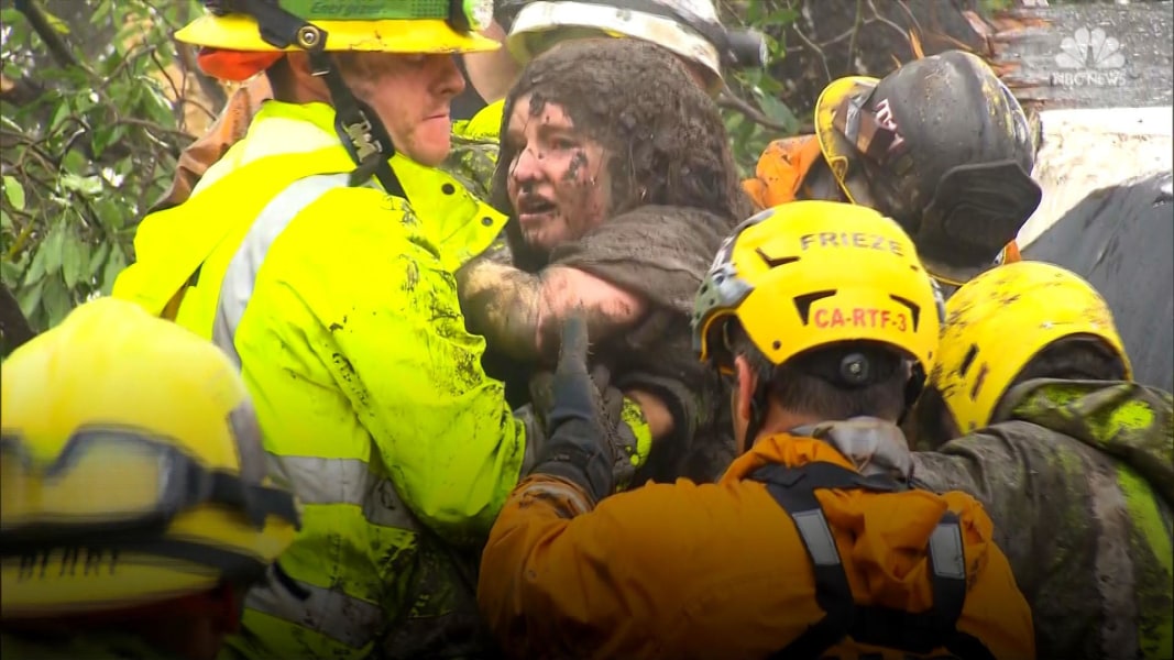
Debris ruptured a gas line in one neighborhood, causing structure fires, and there were 50 rescues by helicopter and dozens more by crews on the ground by Tuesday afternoon, officials said.
In one instance, a 14-year-old Montecito girl was saved from a "tangled mess of a house" that was swept away by raging floodwaters, Eliason said.
The teen — later identified as Lauren Cantin — was discovered when firefighters using dogs in the search heard a scream. It was difficult to hear as the rain continued to fall, they said, but they pinpointed the area where the noise emanated and began to dig.
California rains cause mudslides after devastating wildfires 1:13
Using the jaws of life and other tools, rescuers sheared off debris from around Cantin. They worked for over six hours before freeing her Tuesday morning.
"I thought I was dead there for a minute," Cantin, covered in sludge as she was brought out, told rescuers.
The girl was able to stand and walk with some assistance and was brought to a local hospital.
"To be able to have her come out safely and as unscathed as she was, it was pretty phenomenal," said Andy Rupp, a Montecito Fire Protection District firefighter. 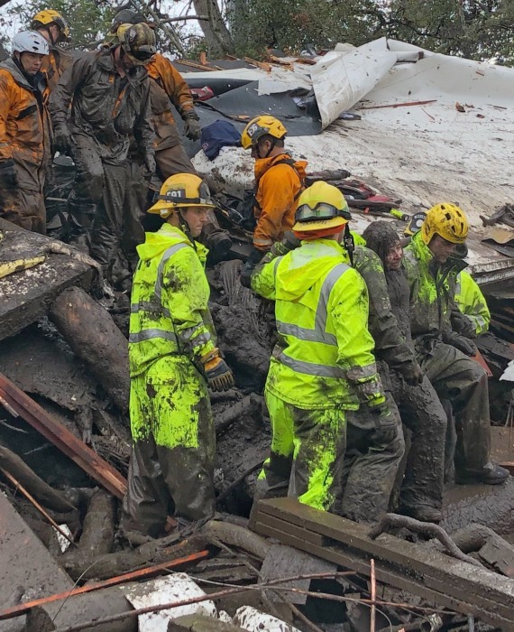
Firefighters rescue a 14-year-old girl Tuesday after she was trapped for hours inside a destroyed home in Montecito. Santa Barbara County Fire
Emergency responders made several rescues in the area after some residents failed to heed warnings the day before to leave. Motorists also had to be rescued as the mud reached waist high in some pockets, Eliason added. The pain-staking rescues were done as more than 1,600 people in Santa Barbara County lost power, reported NBC affiliate KSBY.
There were 25 injuries in Santa Barbara County due to the storm, officials said.
One of those killed was Roy Rohter, who was swept from his Montecito home along with his wife who survived, according to Thomas Aquinas College, which said they have been longtime benefactors of the school.
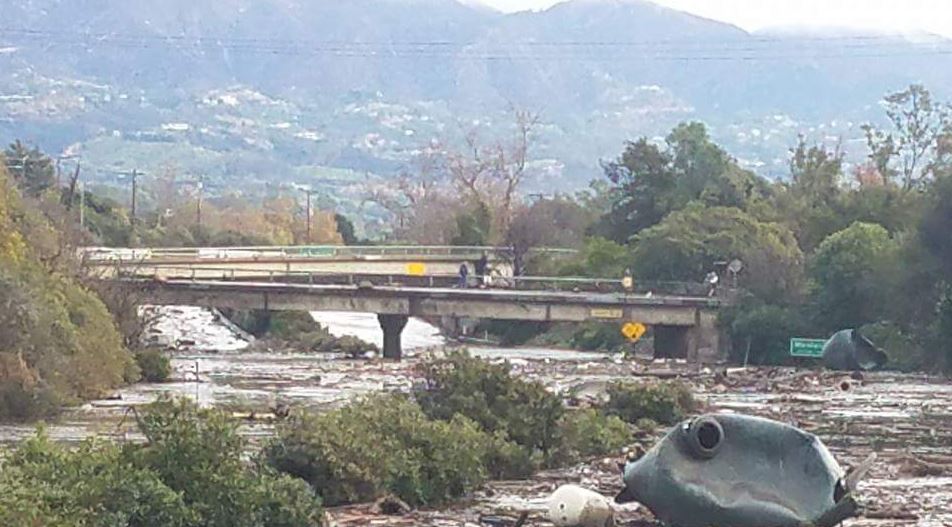
More than 5 inches of rain were collected in the Matilija Canyon rain gauge in Ventura County, according to the National Weather Service in Los Angeles, which issued a flash flood watch for Tuesday after storms rolled in Monday. The flash flood watches in Santa Barbara and Ventura counties were later discontinued.
Thousands of people in parts of Ventura and Los Angeles counties had been ordered to evacuate.
"Rainfall rates were unprecedented,” the National Weather Service said in a statement read at a news conference in Santa Barbara County Tuesday afternoon. A rain gauge at the Carpinteria Fire Department recorded ½ inch of rain in just 5 minutes, according to the weather service.
The rain fell in the burn area of the so-called Thomas Fire that burned last month and which was stoked by Santa Ana Winds, officials said. The rain caused "devastation in the Montecito area of the Thomas burn," Brown said.
Decreasing showers are forecast to end Tuesday night, but officials said search and rescue efforts are continuing. First responders were in the process of evacuating around 300 people trapped in Romero Canyon Tuesday afternoon, Montecito Fire Division Chief Kevin Taylor said
A "catastrophic debris flow" occurred in the Montecito area at around 4 a.m., Taylor said. 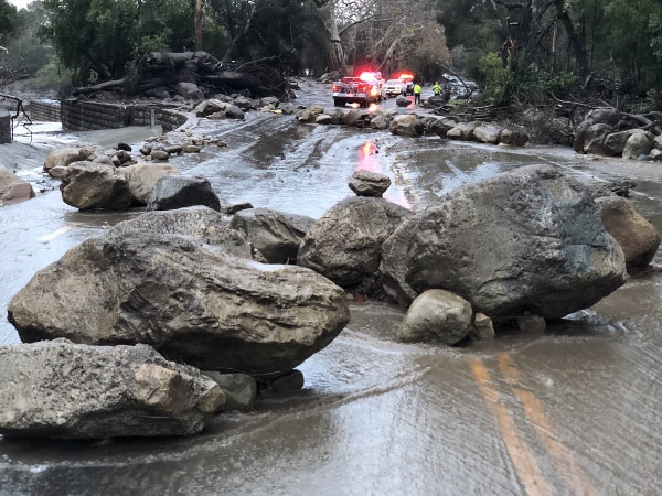
Scene from Hot Springs Road in Montecito, California, following debris and mud flow due to heavy rain on Jan. 9, 2017. Mike Eliason / Santa Barbara Fire PIO
Police tweeted that the 101 Freeway, a major artery that runs along the coast, was shut down from Sea Cliff in Ventura County to Milpas in Santa Barbara County because of the heavy downpour. Vehicles became trapped partially underwater with people needing to be pulled out, fire officials added.
"The only words I can really think of to describe what it looked like was it looked like a World War I battlefield," Brown said of the landslide. "It was literally a carpet of mud and debris everywhere, with huge boulders, rocks, downed trees, power lines, wrecked cars.”
The year's first major rainstorm is a test for parts of California where wildfire-ravaged land has lost crucial vegetation and left hillsides bare. The Thomas Fire is the largest wildfire in state history, fire officials have said, and burned more than 280,000 acres and killed at least two people since early December.
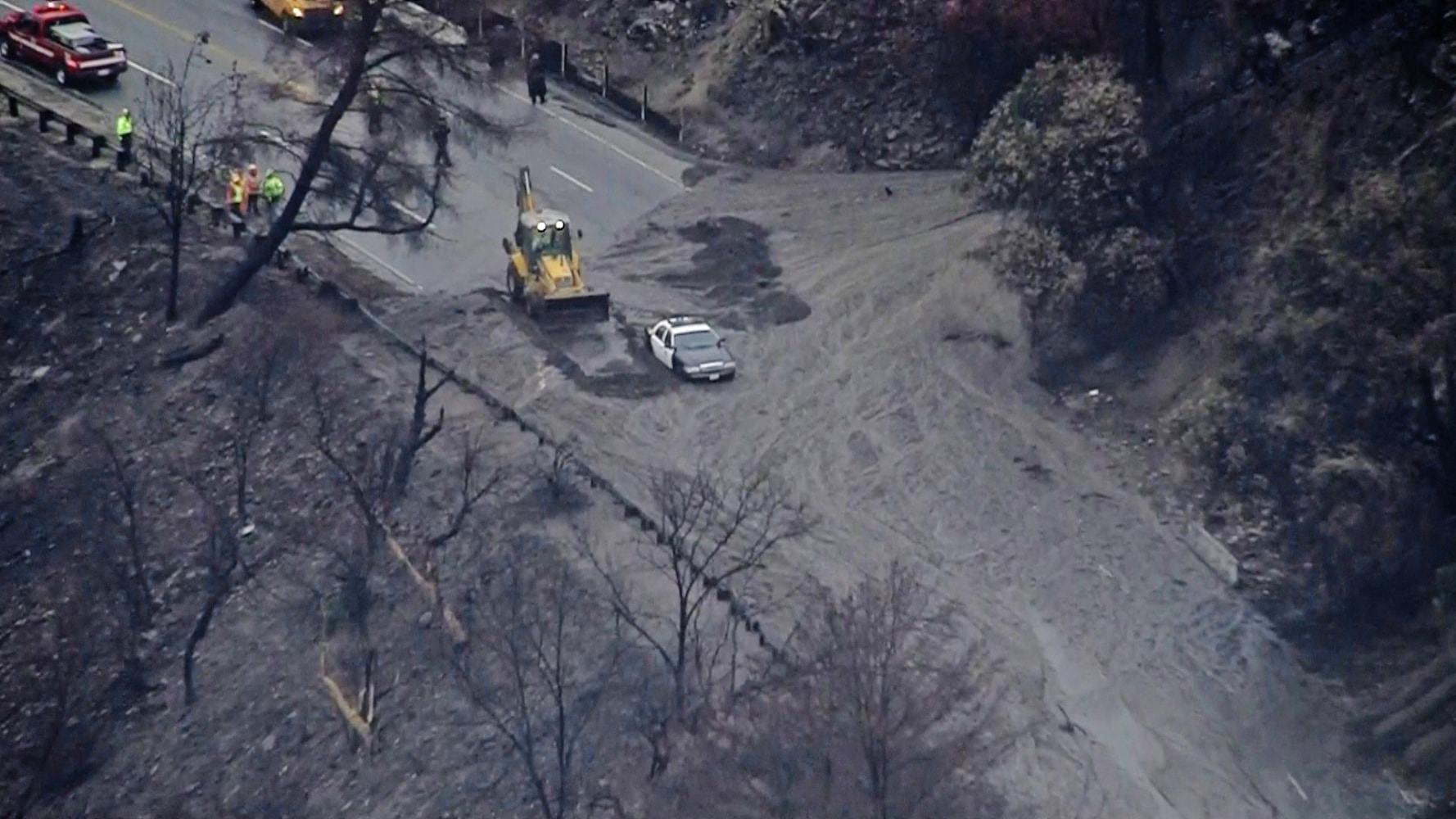
In Burbank, city officials said voluntary evacuations were recommended for neighborhoods near where the La Tuna Fire burned thousands of acres in September.
Mandatory evacuations were ordered for County Club Drive in a mountainous community in Burbank, fire officials said. Aerial video showed rivers of mud — carrying tree limbs along — flowing down the street.
Burbank Fire Battalion Chief John Owings said that a rough assessment showed at least a couple of homes had suffered damage. 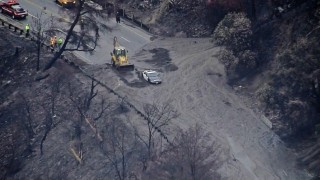
A police car is surrounded by a mudslide in the La Tuna fire burn area in Southern California. NBC News
"Originally under the voluntary evac some folks decided to stay and try to defend their homes but now that they’ve seen the potential of what could come down, they’re being much more cooperative,” Owings said at a news conference at around noon.
"Right now we’re still in a rescue mode and getting all of the occupants out of there," he said. There were between 10 and 20 homes that still needed to be evacuated, he said at the time.
Also making the conditions more dangerous were winds gusting as high as 70 mph — expected through Tuesday night. And the rain isn't expected to taper off until early Wednesday.
A 53-year-old semi truck driver was killed in the Los Angeles area after making an unsafe turn and losing control on Interstate 5, the California Highway Patrol said. It was not immediately clear if the accident was related to the rain, and a cause is still under investigation.
Parts of Santa Barbara County got nearly 3 inches of rain, parts of the Los Angeles metropolitan area saw 1.8 inches of rain, Pasadena got 2.83 inches, and 2.3 inches were reported in Burbank as of 4:40 p.m., the National Weather Service said.
Steady rains and high winds posed a messy Tuesday morning commute in Northern California, NBC Bay Area reported.
Already on Monday, San Francisco saw almost 2 inches of rain through the afternoon, making it the wettest calendar day since Dec. 11, 2014, according to The Weather Channel.
"We're going from one natural hazard straight into another," said Weather Channel meteorologist Danielle Banks.


Large chunk of ice falls from building, crushes teen's car in SoHo
Updated 1 hr 27 mins ago
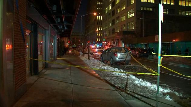
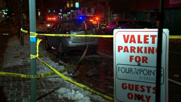
SOHO, Manhattan (WABC) -- A large chunk of snow and ice fell off a building in Manhattan Tuesday, crushing a parked car below.
It happened at about 4:10 p.m. at 70 Charlton Street, a luxury condo building in SoHo.
Police say the snow and ice cascaded down the side of the 21-story building onto the car that was parked on the street.
SCENE PHOTOS: Ice chunk crushes car in SoHo

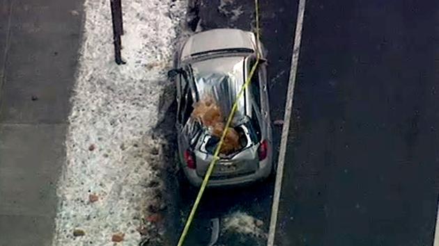
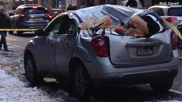

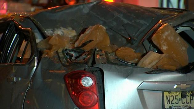
The ice fell on the car of 18-year-old Coltrane Nadler. "I don't know what to think of it, but it seems it was some sort of sign," he said.
Nadler says he was having an existential crisis, wrestling with mortality, when suddenly, the chunk of ice fell from the sky like a bolt of lightning.
"It was very ironic. I couldn't help but see how funny it was," said Nadler.
He could laugh about it Tuesday night because thankfully no one was injured.
The sidewalk was busy with pedestrians and cars were parked bumper to bumper.
But the icy torpedo zeroed in on Coltrane's car and crushed it just as he was coming around the corner.
"Mine was the only one that got hit. I was lucky and unlucky at the same time, depending on how you see it," he said.
Police closed off the block for several hours while they chiseled off the rest of the ice.
The city buildings department also issued a reminder for owners to make sure their buildings are clear of snow and ice, especially on days when the souvenirs of winter can thaw and fall off of tall buildings.
Meanwhile, Coltrane was told insurance would take care of the repairs so he went to his recording session Tuesday night, no doubt pondering the fragile meaning of life.
"I'm in this situation. I'm experiencing this," he said.
The Buildings Department issued a violation to the owner for failure to maintain the building in a safe and code-compliant manner. A water leak on the roof led to the ice buildup, officials said.
The building owner's contractor helped remove the ice and the streets have since been reopened.


PEQUANNOCK, New Jersey (WABC) --
A New Jersey Department of Transportation worker is charged with driving drunk when the snow plow he was operating struck two vehicles.
According to police in Pequannock, 36-year-old Roger Attieh of Boonton sideswiped a vehicle around 5:40 p.m. Monday at the Boulevard and Route 23 intersection.
Attieh exited his truck, inspected the damage, returned to his vehicle, began to drive away and then struck a second vehicle in the rear, police said
No one was injured.
Dawn Coleson saw the plow headed straight for her car. "I held the brakes so I didn't hit the car in front of me and I stopped the car and got out, looked at the damage and banged on the guy's window and said 'you hit me'", said Coleson.
Attieh apologized and waited for police. "He was unsteady on his feet, two police officers had to hold him up. They gave him DWI testing," said Coleson.
Officers saw signs consistent with alcohol impairment. Police say Attieh registered a .37 blood alcohol reading, nine times over the legal threshold for a commercial driver.
He was charged with driving while intoxicated, driving while intoxicated in a commercial motor vehicle and reckless driving.
Attieh has been arrested three previous times for DUI, including once just last month.
In a statement, the DOT said "We take these issues very seriously and the department is fully cooperating with local law enforcement's investigation. Mr. Attieh is an NJ DOT employee and the department has begun its investigation required for disciplinary action."
The Department of Transportation does occasional checks on employees drivers licenses, but didn't catch this one.
===================
Drunk snow plow driver had blood alcohol level nine times legal limit
Don’t drink and plow.
A New Jersey state employee was caught working a snow plow with a blood alcohol degree 9 occasions the authorized restrict for business drivers — his fourth DWI arrest up to now, cops stated.
Roger Attieh, 36, failed his BAC check miserably on Monday after being pulled over in Pequannock by native police, in response to the Every day Document.
He had been plowing snow for the Division of Transportation — nailing two automobiles alongside the best way — when he was stopped by cops.
Within the first crash, cops stated Attieh sideswiped a car, obtained out to examine the injury, after which returned to his DOT truck to proceed his route. He then hit the second automotive as he tried to drive away.
Attieh did all this whereas additionally spreading salt on the snow-coated roadways, the Every day Document stories.
Fortunately, there have been no accidents in both accident.
“NJDOT takes these points very significantly and the division is absolutely cooperating with native regulation enforcement’s investigation,” defined NJDOT Communications Director Steve Schapiro.
“Mr. Attieh is an NJDOT worker and the Division has begun its investigation required for disciplinary motion.”
The state employee already has three DWI arrests on his document — together with his most up-to-date coming simply final month in Denville. He was additionally busted in 2007 and 2002.
Schapiro declined to remark when requested by the Day by day Report concerning the strategy of background checks and driving data.