Eyewitness News
Updated 2 hrs 26 mins ago
NEW YORK (WABC) -- The National Hurricane Center says Tropical Storm Hermine has formed from a system swirling in the Gulf of Mexico, with a path that's projected to pass over the New York City area over the Labor Day weekend.
The center said a hurricane hunter plane has determined that a tropical depression strengthened Wednesday into the named storm and Hermine now boasts top sustained winds of 45 mph.
As of 5 p.m. Wednesday, Hermine is centered about 350 miles west-southwest of Tampa, Florida and is drifting at 7 mph toward the north-northeast.
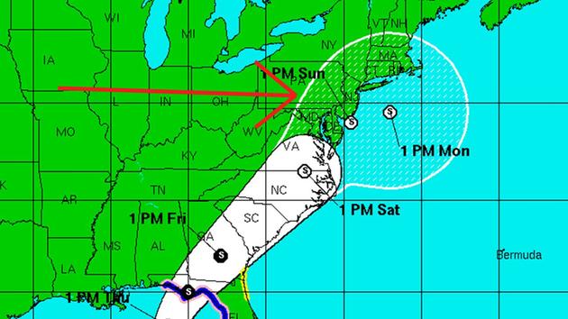
The updated predicted path has the storm moving even farther west, showing all of the Tri-State in the storm's possible path.
Meteorologist Lee Goldberg said if the storm stays over land, it will weaken by the time it reaches our region, but it will still be a significant event. In this scenario, we could expect Nor'easter-like weather, with a lot of rain and wind.
these are the current headlines for the NYC region:
* Rough surf and rip currents through the Labor Day weekend
* Saturday is best bet for weekend plans, but clouds will be increasing throughout the day
* Brunt of Hermine would be on Sunday
Here is the projected path of this storm:

The National Hurricane Center in Miami issued a hurricane watch and tropical storm warning for parts of Florida stretching from northwest of Tampa to an area east of Panama City, as well as a tropical storm watch on the east coast of Florida and Georgia.
Eric Blake of the National Hurricane Center in Miami says the storm will likely dump around 5 inches of rain on areas of central and north Florida as it approaches the state Thursday. Some areas could see up to 15 inches of rain.
This interactive map allows you to see the real-time status of each system:
This storm was originally called Tropical Depression 9 (TD9).