
Eyewitness News
Updated 30 mins ago
NEW YORK (WABC) -- The National Hurricane Center says Tropical Storm Hermine has formed from a system swirling in the Gulf of Mexico, and this storm is projected to come close to the New York City area over the Labor Day weekend.
The Miami-based center says a hurricane hunter plane has determined that a tropical depression strengthened Wednesday into the named storm and Hermine now boasts top sustained winds of 40 mph (65 kph).
It says Hermine is centered about 415 miles (665 kilometers) west-southwest of Tampa, Florida and is drifting at 2 mph (4 kph) toward the north.
The center says the tropical storm should turn more toward the northeast with increasing speed on Thursday and is on a forecast track that would approach the northwest Florida coast about Thursday afternoon.
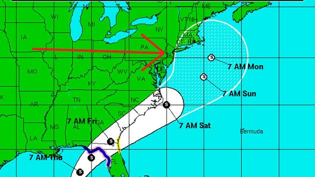
Here is the projected path of this storm:

The updated predicted path is has moved farther west, showing all of Long Island and Connecticut in the storm's possible path.
Lee Goldberg said the New York City area is in the fringe part of the storm's path. It's predicted to be up near New England Saturday and Sunday.
The National Hurricane Center in Miami issued a hurricane watch and tropical storm warning for parts of Florida stretching from northwest of Tampa to an area east of Panama City, as well as a tropical storm watch on the east coast of Florida and Georgia.
As the tropical depression looms in the Gulf of Mexico, heavy rainfall is expected across much of Florida. Eric Blake of the National Hurricane Center in Miami says the storm will likely dump around 5 inches of rain on areas of central and north Florida as it approaches the state Thursday. Some areas could see up to 15 inches of rain.
This interactive map allows you to see the real-time status of each system:
This storm was originally called Tropical Depression 9 (TD9).