MEC&F Expert Engineers

Thursday, October 1, 2015

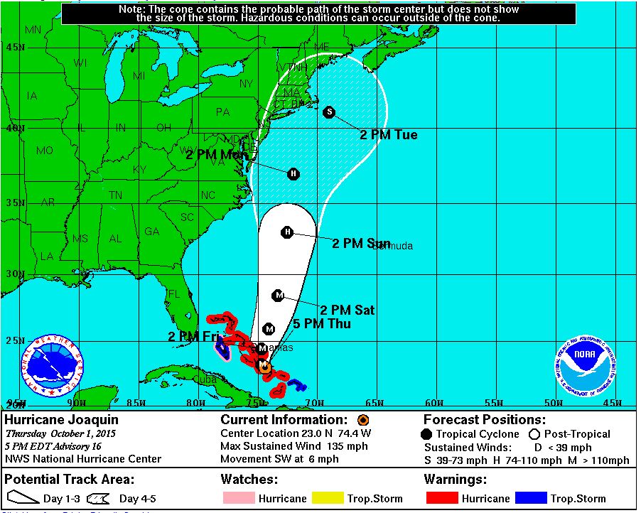
UPDATE: PROBABLE PATH OF HURRICANE JOAQUIN


BULLETIN
HURRICANE JOAQUIN ADVISORY NUMBER  16
NWS NATIONAL HURRICANE CENTER MIAMI FL       AL112015
500 PM EDT THU OCT 01 2015

...EXTREMELY DANGEROUS CATEGORY 4 JOAQUIN MOVING THROUGH THE
CENTRAL BAHAMAS...
...HURRICANE CONDITIONS TO CONTINUE OVER THE CENTRAL BAHAMAS
TONIGHT...


SUMMARY OF 500 PM EDT...2100 UTC...INFORMATION
----------------------------------------------
LOCATION...23.0N 74.4W
ABOUT 15 M....25 KM NW OF CROOKED ISLAND BAHAMAS
ABOUT 70 MI...110 KM S OF SAN SALVADOR BAHAMAS
MAXIMUM SUSTAINED WINDS...130 MPH...215 KM/H
PRESENT MOVEMENT...SW OR 235 DEGREES AT 6 MPH...9 KM/H
MINIMUM CENTRAL PRESSURE...936 MB...27.64 INCHES


WATCHES AND WARNINGS
--------------------
CHANGES WITH THIS ADVISORY:

None.

SUMMARY OF WATCHES AND WARNINGS IN EFFECT:

A Hurricane Warning is in effect for...
* Central Bahamas
* Northwestern Bahamas including the Abacos, Berry Islands,
Eleuthera, Grand Bahama Island, and New Providence
* The Acklins, Crooked Island, and Mayaguana in the southeastern
Bahamas

A Hurricane Watch is in effect for...
* Bimini
* Andros Island

A Tropical Storm Warning is in effect for...
* Remainder of the southeastern Bahamas including the Turks and
Caicos Islands
* Andros Island

A Hurricane Warning means that hurricane conditions are expected
somewhere within the warning area. Preparations to protect life and
property should be complete in the central Bahamas.

A Hurricane Watch means that hurricane conditions are possible
within the watch area.

A Tropical Storm Warning means that tropical storm conditions are
expected somewhere within the warning area.

For storm information specific to your area, please monitor products
issued by your national meteorological service.


DISCUSSION AND 48-HOUR OUTLOOK
------------------------------
At 500 PM EDT (2100 UTC), the center of Hurricane Joaquin was
located near latitude 23.0 North, longitude 74.4 West. Joaquin is
moving toward the southwest near 6 mph (9 km/h), and a westward or
southwestward motion is expected through tonight. A turn toward the
north is expected on Friday, and a faster motion toward the north is
expected Friday night and Saturday.  On the forecast track, the
center of Joaquin will move near or over portions of the central
Bahamas tonight and pass near or over portions of the northwestern
Bahamas on Friday.

Maximum sustained winds are near 130 mph (215 km/h) with higher
gusts.  Joaquin is a category 4 hurricane on the Saffir-Simpson
Hurricane Wind Scale.  Some additional strengthening is possible
tonight and Friday, with some fluctuations in intensity possible
Friday night and Saturday.

Hurricane-force winds extend outward up to 45 miles (75 km) from the
center and tropical-storm-force winds extend outward up to 175 miles
(280 km).

The estimated minimum central pressure is 936 mb (27.64 inches).


HAZARDS AFFECTING LAND
----------------------
WIND:  Hurricane conditions are expected to continue across portions
of the central and southeastern Bahamas through Friday. Hurricane
conditions are expected over portions of the northwestern Bahamas
tonight and Friday.  Tropical storm conditions will affect other
portions of the southeastern Bahamas, and the Turks and Caicos
Islands through tonight.

STORM SURGE:  A very dangerous and life-threatening storm surge will
raise water levels by as much as 5 to 10 feet above normal tide
levels in the central Bahamas in areas of onshore flow.  A storm
surge of 2 to 4 feet above normal tide levels is expected in the
remainder of the Bahamas within the hurricane warning area.  Near
the coast, the surge will be accompanied by large and dangerous
waves.

RAINFALL:  Joaquin is expected to produce total rain accumulations
of 10 to 15 inches over the central Bahamas with isolated maximum
amounts of 20 inches.  Rainfall amounts of 5 to 10 inches are
expected over the southeastern Bahamas, with 2 to 4 inches over the
northwestern Bahamas. This rainfall could result in life-threatening
flash floods.  Outer rain bands of Joaquin may affect portions of
eastern Cuba, Haiti, and the Dominican Republic today and tonight.

SURF:  Swells generated by Joaquin will affect portions of the
Bahamas during the next few days, and will begin to affect portions
of the southeastern coast of the United States tonight and spread
northward through the weekend.  These swells are likely to cause
life-threatening surf and rip current conditions.  Regardless of
Joaquin's track, a prolonged period of elevated water levels and
large waves will affect the mid-Atlantic region, causing significant
beach and dune erosion with moderate coastal flooding likely. Please
consult products from your local weather office.


NEXT ADVISORY
-------------
Next intermediate advisory at 800 PM EDT.
Next complete advisory at 1100 PM EDT.
 
//-----------------------------///
 
HURRICANE JOAQUIN DISCUSSION NUMBER  12
NWS NATIONAL HURRICANE CENTER MIAMI FL       AL112015
500 PM EDT WED SEP 30 2015

There has been little change in the organization of Joaquin during
the past several hours.  While the hurricane continues to produce
cloud tops colder than -80C in the eyewall, the eye has not become
better defined since the last advisory.  Satellite intensity
estimates are 77 kt from both TAFB and SAB, so the advisory
intensity is now 75 kt.

The initial motion is 225/7.  The shortwave ridge causing this
motion is expected to weaken during the next 24-48 hours as a strong
deep-layer trough develops over the southeastern United States.
Thus, a generally southwestward motion is expected for the next 36
hours or so, followed by a turn toward the north as the trough
becomes the dominant steering mechanism.  There is an increased
disagreement between the GFS, UKMET, Canadian, and NAVGEM models
versus the ECMWF since the last advisory.  The ECMWF has continued
its forecast of showing a northeastward motion after 72 hours,
taking Joaquin just west of Bermuda and out to sea.  The other
models have all shifted their forecasts to the left and now
call for landfall in the Carolinas and the mid-Atlantic states,
followed by merger with the baroclinic trough.  Given the shift in
the non-ECMWF models, a major westward adjustment has been made to
the forecast track at 96 and 120 hours, bringing the center of
Joaquin near or over portions of the mid-Atlantic states.  Due to
the use of the ECMWF in the consensus models, the new track lies
near the various consensus models.  However, it lies well to the
east of the GFS and the other similar models.  The NOAA G-IV jet is
currently flying a synoptic surveillance mission, which, along with
special rawinsonde launches, hopefully will reduce the spread of the
guidance.

There is little change to the intensity forecast philosophy since
the last advisory.  Joaquin is expected to remain in an environment
of moderate northeasterly vertical shear for the next 24-36 hours,
possibly including strong winds seen at 400 mb in recent dropsondes
from the G-IV aircraft.  However, since it has been steadily
strengthening in such an environment, there is no obvious reason to
think it will stop doing so.  After 36 hours, the hurricane is
likely to move into an area of divergent southerly upper-level winds
associated with the eastern U. S. trough.  While there is
uncertainty as to how much shear should occur, it is expected that
additional intensification could occur through at least 48 hours.
Based on this, the intensity forecast calls for Joaquin to peak as a
major hurricane in 48-72 hours, and it is possible it could be
stronger than currently forecast.  After 72 hours, increasing shear,
cold air intrusion, and land interaction should cause weakening and
the start of extratropical transition.


KEY MESSAGES:

1.  Preparations to protect life and property within the warning
areas in the Bahamas should be rushed to completion.

2.  A significant adjustment to the forecast has been made this
afternoon, and this shows an increased threat to the mid-Atlantic
states and the Carolinas.  However, confidence in the details of the
forecast after 72 hours remains low, since we have one normally
excellent model that keeps Joaquin far away from the United States
east coast.   The range of possible outcomes is still large, and
includes the possibility of a major hurricane landfall in the
Carolinas.

3.  Every effort is being made to provide the forecast models with
as much data as possible.  The NOAA G-IV jet has begun a series of
missions in the storm environment, and the National Weather Service
is launching extra balloon soundings.

4.  Because landfall, if it occurs, is still more than three days
away, it is too early to talk about specific wind, rain, or surge
impacts from Joaquin in the United States.   Even if Joaquin stays
well out to sea, strong onshore winds will create minor to moderate
coastal flooding along the coasts of the mid-Atlantic and
northeastern states through the weekend.

5.  A hurricane watch for a portion of the U.S. coast could be
required as early as Thursday evening.

6.  Many areas of the eastern U.S. are currently experiencing heavy
rains and gusty winds associated with a frontal system.  This
inclement weather is expected to continue over the next few days,
which could complicate preparations for Joaquin should it head
toward the coast, and greatly exacerbate the impacts from the
hurricane.  Heavy rains are likely to continue over these areas
even if the center of Joaquin stays out to sea.


FORECAST POSITIONS AND MAX WINDS

INIT  30/2100Z 24.3N  73.1W   75 KT  85 MPH
 12H  01/0600Z 24.0N  73.8W   85 KT 100 MPH
 24H  01/1800Z 23.9N  74.5W   90 KT 105 MPH
 36H  02/0600Z 24.5N  75.0W   95 KT 110 MPH
 48H  02/1800Z 25.8N  75.0W  100 KT 115 MPH
 72H  03/1800Z 30.5N  74.5W  100 KT 115 MPH
 96H  04/1800Z 36.0N  75.5W   85 KT 100 MPH
120H  05/1800Z 38.5N  76.5W   55 KT  65 MPH

JOAQUIN IS COMING, PREPARE FOR: flash flooding, river flooding, gusty winds, high surf, beach erosion and some coastal flooding at high tide.


Eastern U.S. Flood Threat to Continue No Matter Where Hurricane Joaquin Tracks


By Chris Dolce

Published Oct 1 2015 03:38 PM EDT


Disastrous Flooding Scenario Possible

Meteorologist Domenica Davis looks at the expected rainfall along the east coast that will likely result in flash floods.

The forecast for the East Coast is looking increasingly ominous as a complex weather pattern promises to deliver more heavy rainfall to a region that is already dealing with flooding from recent deluges.

Thursday through this weekend, deep tropical moisture from the Caribbean Sea and the western Atlantic will be involved in this soaking setup as a front stalls near the East Coast. This situation is serious with historic and potentially life-threatening rainfall possible in some locations, especially in parts of South and North Carolina.

Significant impacts are likely in portions of the East, whether Hurricane Joaquin tracks towards the United States or not, due to the large-scale weather pattern taking shape. This will include, flash flooding, river flooding, gusty winds, high surf, beach erosion and some coastal flooding at high tide.

In many areas, the ground is already saturated due to heavy rain that fell earlier this week. The heavy rain that impacted northern New England on Wednesday has since moved out of the area. This batch of moisture-rich air came from the Gulf of Mexico and fueled torrential downpours along a slow-moving cold front. This brought significant flooding to parts of Virginia, New York, North Carolina, Maine, Maryland, Pennsylvania and Ohio.


Rainfall Totals End of September

Shaded areas indicate estimated rainfall totals and plotted amounts are rainfall totals from airport sites and co-operative observers from Sept. 23-30.

Several daily rainfall records were set on Wednesday in New England, some of which include Portland, Maine with 5.56 inches (previous record was 2.14 inches in 1920), Boston, Massachusetts with 2.46 inches (previous record was 1.26 inches in 1899) and Providence, Rhode Island with 2.02 inches (previous record was 0.95 inches in 1946).


Current Radar

Current radar, along with any valid flash flood warnings (green outlines), severe thunderstorm warnings (yellow) or tornado warnings (red). Image updates every 5 minutes; refresh your browser for the latest image.
Thursday Through This Weekend: More Heavy Rain; Wind, Coastal Impacts Possible

As the aforementioned front stalls, a jet stream dip will dig south across the eastern states and an upper-level area of low pressure will develop in the Southeast. This will allow one or more waves of low pressure to develop along the front that will tap abundant tropical moisture, helping to pull more rain into parts of the East.


Setup Late Week-Weekend

The white lines in this graphic are isobars showing the gradient between high pressure in Canada and lower pressure near the front. Also shown is the sharp jet stream dip. Orange, red and purple shadings illustrate tropical moisture.

At the same time, strong high pressure in eastern Canada will help create a large pressure gradient along the East Coast, increasing the potential for gusty winds, coastal flooding, high surf and beach erosion.

The rain and coastal impacts would begin in advance of any threat from Hurricane Joaquin. Uncertainty remains high on where Joaquin will eventually track. However, even if the center does not make a direct hit on the U.S., rich tropical moisture will still be involved in the soaking setup in the East. For more details on the uncertainties with Joaquin, click the link below.


Here are the potential impacts on the table starting Thursday and lasting through this weekend, no matter whether Joaquin approaches the U.S. or not:

Rainfall, Flooding: River flooding and flash flooding are both likely in parts of the East. There is uncertainty regarding where the heaviest rain may occur; however, areas from the Mid-Atlantic to the central Appalachians and the Carolinas appear to be the epicenter for the heaviest rainfall amounts. Totals could exceed 5 inches in many locations, with some areas having the potential to see more than a foot of rain. Areas farther north into New England should also monitor this situation as well.

Flash flood watches have been issued by the National Weather Service from Maryland southward into most of Virginia, the Carolinas, northeastern Georgia and eastern Tennessee. The National Weather Service office in Greer, South Carolina stated in their forecast discussion Thursday afternoon that a "historic and potentially life-threatening rainfall event is expected this weekend."


Inland Flood Alerts

The latest flood watches and warnings issued by the National Weather Service across the region. These alerts pertain to freshwater flooding resulting from heavy rainfall.


Rainfall Forecast: Next 7 Days

Forecast rainfall, in inches, for the next seven days. Given the uncertainty surrounding the future of Joaquin, the region and magnitude of the heaviest rainfall is likely to change somewhat in future forecasts.

Increasing Winds: The gradient between lower pressure near the stalled front and a strong area of high pressure anchored from eastern Canada into the Midwest will help increase winds late this week. Depending on how this weather pattern unfolds, the strong winds could impact coastal areas of the Northeast and Mid-Atlantic right through this weekend. If Joaquin approaches the U.S. coast, there will be a core of much stronger winds, but that remains uncertain.

The National Weather Service has already hoisted high wind watches valid Friday and Saturday for parts of southern New Jersey in anticipation of this windy setup, which could produce gusts of 50 to 60 mph.

Coastal Impacts: The winds could contribute to high surf, beach erosion and coastal flooding in some locations along the Northeast and the Mid-Atlantic coast.


Coastal Flood Alerts

A look at the coastal flood watches, warnings and advisories issued by the National Weather Service along the East Coast. These pertain to flooding caused by seawater pushed onshore by the wind, i.e., storm surge.

The National Weather Service has issued coastal flood watches for the Atlantic coastline from the New Jersey shore south to Virginia Beach and portions of the Carolinas, including the beaches of Delaware and Maryland, and for areas surrounding the lower Chesapeake Bay.

According to the watch bulletins, major coastal flooding may occur along the Atlantic coast of the Delmarva Peninsula as well as the Atlantic-facing coastlines of Cape May and Atlantic counties in southern New Jersey. This means flooding may be severe enough not only to flood numerous roads in coastal areas, but also to flood homes and businesses.

Major coastal flooding may also affect portions of the Virginia Tidewater, including the Hampton Roads metropolitan area encompassing Norfolk, Virginia Beach, Portsmouth, Newport News, and other nearby cities in southeastern Virginia.
Timing of the Rain

This will be a prolonged heavy rain event that will result in rainfall totals over 6 inches over a large area and some locations will likely measure over a foot of rainfall through Sunday. The soil is already saturated in many of the areas expecting heavy rainfall and may lead to dangerous flooding. Landslides and debris flows are also a threat this weekend.

Thursday Night: Widespread heavy rain is expected to begin tonight from Georgia into the Carolinas and Virginia, as well as into eastern Maryland and Delaware. The heaviest rainfall is likely in southeastern Georgia into eastern South Carolina, eastern North Carolina and southeastern Virginia.


Thursday Night's Forecast

Friday: Heavy rain will spread farther north and west during the day, with moderate to heavy rain likely from New York City to Washington, D.C. and through Virginia, West Virginia, and into the Carolinas and parts of Georgia. At this time, the heaviest rain will likely be in portions of North and South Carolina where torrential rainfall is possible.


Friday's Forecast

Saturday: Widespread moderate to heavy rain will impact areas from eastern Georgia through South Carolina, North Carolina, Virginia into West Virginia, eastern Kentucky, southeastern Ohio and southwestern Pennsylvania. Locations as far north as southern New York will see lighter rainfall.


Saturday's Forecast

Sunday: The area expecting heavy rain will shrink and be focused mainly from South Carolina into North Carolina and parts of Virginia. However, showers will remain possible for much of the Southeast and Mid-Atlantic.


Sunday's Forecast

A drying trend is expected to begin early next week across the East.

Check back with weather.com for updates in the days ahead as we provide more specifics on this forecast.

HURRICANE JOAQUIN HAS THE POTENTIAL TO CAUSE MAJOR FLOOD DAMAGE IN THE ALREADY SOAKED EASTERN SEABOARD STATES


1 dies in flooding as storms threaten to move up East Coast


Photo by:

The Associated Press


A motorist drives through flooding water in Portland, Maine, Wednesday, Sept. 30, 2015. Heavy rain has been moving through northern New England and a flood warning was issued for parts of Maine and New Hampshire. (AP Photo/Robert F. Bukaty)


Thursday, October 1, 2015


Big Flood Threat From Hurricane Joaquin
Weather Channel


SPARTANBURG, S.C. — Torrential flooding submerged cars, shut down roads, and led to at least one death Thursday as the rain-saturated East Coast braced not only for more precipitation but for a possible strike by a major hurricane.

Governors up and down the coast warned residents to prepare. The rains could cause power outages and close more roads. The approach of Hurricane Joaquin (wah-KEEN') — a major Category 4 storm set to wallop the Bahamas and move toward the U.S. — could intensify the damage, but rain is forecast across the region regardless of the storm's path.

New York Gov. Andrew Cuomo said Thursday that the state is already moving equipment, including generators and pumps, into position while state emergency officials watch the storm's progress. Upgrades and repairs made after Superstorm Sandy and Hurricane Irene have made New York and New York City better prepared for the next tropical storm, Cuomo said.

In Spartanburg, South Carolina, the heavy rains flooded and closed streets. Several cars were submerged in flash floods. One man was rescued Thursday morning after his vehicle was swept off the road where a culvert had washed out, Doug Bryson with Spartanburg County Emergency Management told local news outlets. The man managed to cling to a tree and was taken to a hospital for treatment, though there was no immediate word on his condition.

Spartanburg County Coroner Rusty Clevenger said 56-year-old Sylvia Arteaga of Spartanburg died Thursday morning. She was driving underneath an overpass just outside city limits when her car flooded "to capacity" inside.

Members of the Arteaga family who lived next door to the woman's home declined requests for comment Thursday. A neighbor, Martha Rodriguez, called Arteaga a good person who worked very hard to care for her two children. Rodriguez said Arteaga worked at a factory.

Meanwhile, Hurricane Joaquin was bearing down on the Bahamas, and forecasters said the storm is likely to strengthen as it makes its way toward the U.S.

But no matter which way Joaquin heads, an area of low pressure in the Southeast and a front stalled over the East Coast will pull moisture from the Atlantic Ocean, causing rain over the next few days, said Bruce Terry, lead forecaster for the government's Weather Prediction Center. The National Weather Service predicts as much as 10 inches for some areas.

"The bottom line is: We are expecting very heavy rains all the way from the Carolinas up into New England," he said.

The heaviest rain is expected in wide swaths of North Carolina and Virginia, along with parts of Maryland, Delaware and New Jersey, according to a National Weather Service forecast map.

The National Weather Service issued flash flood watches for Washington D.C., northern Virginia, southern Maryland and the Eastern Shore from Friday morning through late Saturday. Coastal flood warnings and advisories are in effect during the same period in central and southern Delaware and on the Eastern Shore.

Researchers at the University of Michigan and Texas A&M University predict as many as 14 million people could lose power depending on where the storm hits the U.S.

Seth Guikema and Steven Quiring said they accurately predicted the loss of power for millions during Sandy. They look at wind speed, storm path and population density.

"Joaquin could have power outage impacts on par with those of Sandy if it maintains a track towards major East Coast population centers, though there is substantial uncertainty about the track," said Guikema, a University of Michigan associate professor of industrial and operations engineering.

In North Carolina, Gov. Pat McCrory declared a state of emergency Thursday and said emergency management officials are preparing for expected floods by readying supplies and going over readiness checklists.

Virginia Gov. Terry McAuliffe declared a state of emergency Wednesday afternoon, which allows emergency responders to begin to prepare for the storms.

He also issued tips to residents, including that "when roads are flooded, turn around and drive to a safe location.

"It may save your life."

In New Jersey, Gov. Chris Christie also declared a state of emergency. New Jersey has been hit by intermittent heavy rains and strong on-shore winds the last few days, and that's expected to continue, especially Friday and Saturday.

Maryland Gov. Larry Hogan declared a state of emergency to allow emergency responders to begin to prepare.

Officials were closely watching the progress of the hurricane, though its path was far from certain. So far, there's been little consensus among computer-prediction models for the hurricane.

The National Hurricane Center in Miami sent a plane aloft Wednesday to gather data about Joaquin that will hopefully "get those models into better agreement," said Rick Knabb, the center's director.

"We're going to be throwing a lot more aircraft resources at this problem over the next few days," he said.

In New England, hundreds of cars were damaged by high water around the region, with some of them totaled and others needing expensive repairs, officials said Thursday. More than 6 inches of rain fell Wednesday in Maine, while New Hampshire got more than 5 inches. Vermont also got heavy rain, but not as much.

HURRICANE JOAQUIN HAS THE POTENTIAL TO CAUSE MAJOR FLOOD DAMAGE IN THE EASTERN SEABOARD STATES


Gov. Larry Hogan declares state of emergency in Maryland
Heavy rains, flooding expected as Hurricane Joaquin approaches 


UPDATED 4:01 PM EDT Oct 01, 2015


BALTIMORE, MD


Maryland Gov. Larry Hogan has declared a state of emergency to allow emergency responders to begin to prepare for flooding from heavy rains and damage from a hurricane.


Powerful Hurricane Joaquin pounded lightly populated islands of the eastern Bahamas on Thursday, and forecasters said it could grow more intense while following a path that would near the U.S. East Coast by the weekend.


Baltimore Gas and Electric Company is monitoring Hurricane Joaquin, which some forecasts indicate could affect the mid-Atlantic region.


The governor spoke Thursday afternoon from the Maryland Emergency Management Agency in Reisterstown.

"Out of an abundance of caution, moments ago, I signed an executive order declaring a state of emergency here in Maryland in anticipation of Hurricane Joaquin. This is a proactive measure to ensure that all necessary resources are mobilized in areas of our state with the great potential needs, particularly of concern are coastal and low-lying areas of the state that are highly suspticble to flooding," Hogan said.


Drenching storms are moving up the East Coast, a region already swamped by rain from earlier this week. The water has done damage in the Carolinas and southwest Virginia, and could cause power outages and close roads in the Mid-Atlantic.

The approach of Joaquin could intensify the damage, but rain is forecast across the region regardless of that storm's path.

"While we're hoping for the best, we're preparing for the worst," Hogan said.


Hogan said state shelter have been put on standby and utility companies have been put on high alert.


"Our state is taking every precaution and I urge Marylanders to do the same," Hogan said. "Start now to prepare your families (and) your homes for potential heavy rains, winds and possible flooding. More importantly, use common sense."

Local authorities warned residents Thursday to clear drains and remove or secure outdoor furniture before days of heavy rain that are already canceling events around the region.

Maryland's football game against Michigan is moving from 8 p.m. to noon on Saturday. The University of Delaware canceled Sunday's Coast Day, which typically draws 10,000 people to the coastal town of Lewes.

National Weather Service issue flash flood watches

The National Weather service has issued flash flood watch for Washington, northern Virginia, southern Maryland and the Eastern Shore from Friday morning through late Saturday. Coastal flood warnings and advisories are in effect during the same period in central and southern Delaware and on the Eastern Shore.


The NWS said many portions of the eastern U.S. are experiencing heavy rains and gusty winds associated with a frontal system. These heavy rains are likely to continue for the next few days, even if the center of Hurricane Joaquin stays offshore.

The resulting inland flood potential could complicate preparations for Joaquin should it head toward the coast, and even more substantial inland flooding is possible, NWS said.


The NWS said a coastal flood watch remains in effect from 9 p.m. Thursday through Saturday afternoon for Maryland beaches.

During the noon Thursday weather forecast, 11 News Meteorologist Miri Marshall said we can expect heavy rain on Friday with a potential for flooding in the Maryland region, with 3 inches of rain possible between now and early Saturday morning.

Flash flood warnings are in effect for parts of the region, including Anne Arundel and Howard counties and points south, while portions of the Eastern Shore are under a flood watch, Marshall reports.

Meanwhile, Thursday's forecast includes cloudy conditions, with light to moderate rain possible, winds 5 mph to 10 mph and temperatures reaching the low 60s.

Joaquin is a Category 3 storm with maximum sustained winds of 125 mph and hurricane strength winds extending 45 miles from the eye, the U.S. National Hurricane Center in Miami said. As of 11 a.m. EDT Thursday, the center of the storm was passing over Samana Cay, and the Bahamas and was moving west-southwest at 6 mph.

Marylanders can visit MEMA.Maryland.gov for more information.

Monitor the changes by watching 11 News newscasts, through the WBAL weather app and at WBALTV.com.

Metropolitan Engineering, Consulting, Forensics, and Environmental Remediation Services. Construction, Investigation, Remediation and Forensic Expert Engineers


Construction Defects, Construction Claims, Engineering, Property & Casualty Investigations, Assessment, Site Investigation, Remediation, Litigation and Indoor-Air Expert Engineers


Bill Stephan, PhD, PE, CIH, CHMM, JD, MBA

Principal Engineer


P.O. Box 520

Tenafly, New Jersey 07670-0520

Phone: (973) 897-8162

Fax: (973) 810-0440


______________________________________________________________________


Firm Overview


The engineering and forensic firm of Metropolitan Forensics and Consulting Engineering and Environmental Services was established for the purpose of providing a high value service to the insurance industry and to the insured companies or individuals. Our founding principal (Bill Stephan) is a licensed professional engineer in several states, including, New Jersey, New York, Pennsylvania, and Delaware.


We specialize in the in-situ remediation of petroleum and chlorinated spills, the defense of liability claims, the investigation and defense of first or third party insurance claims and the handling of subrogation claims.  We are also experts on oil and gas energy sector issues (design, investigations, construction oversight), renewable energy sector (wind turbines, solar panels, biofuels, etc), vapor intrusion evaluation, vapor phase and transport and in design on vapor mitigation systems.  Additionally, we offer forensic engineering services, including age-dating of contaminant releases, construction defects, oversight, evaluation of remedial alternatives, sub-slab ventilation system design and installation.  The list of our core services is:


  • Cause and Origin Investigations
  • Construction Failure Analysis (Residential, Industrial and Commercial)
  • Structural Integrity Evaluation
  • Site Investigation
  • Tank removals and tank installations; licensed and insured to perform entire UST work
  • In-Situ Remediation of Soil and Groundwater
  • Vapor intrusion, indoor air evaluation and mitigation
  • Causation
  • Forensic Investigations (age-dating)
  • Oversight
  • Review of Remedial Action Work Plans
  • Reserve Estimation
  • Cost Allocation
  • RAWP Preparation
  • Site Remediation
  • Cleanup Level Development and Negotiation
  • Subrogation
  • Expert Witness/Litigation Support
  • Licensed Site Remediation Professional (LSRP) Services
  • Construction Claims (Delay, Differing Site Conditions, Loss of Productivity, Acceleration, and others)


Additional Specialty Service Areas

Age Dating
Boilers & Burners
Bridges
Building Codes
Building Inspections


Construction Accident
   Reconstruction
Construction Defects
Construction Delay Claims

Construction Surety Claims
Construction Disputes
Construction Differing Condition Claims
Construction Oversight
Construction Management
Construction Acceleration Claims

Construction Failures
Construction Injuries
Contractor Performance Issues
Corrosion


Defective Designs
Defective Roadway Design
   Evaluations


Earthquake
Electrical Accidents/Injuries
Electrical Equipment Failures
Electrical Fires
Elevators, Escalators
   & Conveyors
Embedded Software Hazards
   & Analysis
Equipment Failures
Errors and Omissions
Explosions

Failure Analysis
Fire
Fire Codes
Fire Protection Systems
Fire Suppression Systems

Flood Damage Assessment

Foundation Systems

Gas Systems

Hailstorm damage

Heating & Ventilation Systems
Heavy Construction
Highway/Roadway Design
Human Factors


Indoor Air Quality
Laboratory Services
Ladders, Scaffolding Falls
   & Failures
Lightning

Mechanical Defect Evaluations
Metallurgical Age Dating
Mold Causation
Natural Disasters/Weather
   Related Issues
Nuclear Energy
Occupational Hazards
   & Illness

Piping
Playground Equipment Injuries
Plumbing
Product Failures
Roofing Problems & Failures
Safety Codes
Safety & Human Factors
   Engineering
Scalding
Scene Mapping and Photographs
Sick Building Syndrome
Sports Equipment Injuries
Standardized Codes
Steam Systems
Subrogation Issues


Transportation Issues
Trips, Slips & Falls
Underground Storage Tanks
Utilities Expertise
Vibration
Water Damage
Windstorm


Mission Statement


Our mission is to work as an extension of our clients to expeditiously achieve the most economically favorable resolution of claims on their behalf and on behalf of their insured. We have developed and will continue to create new solutions to the technical problems and issues which are facing the insurance industry and the insureds today.  

Metropolitan provides forensic engineering work (age-dating or fingerprinting), site remediation, auditing, cost control and litigation support services to insurance carriers, their insureds and to private or public companies.  In its risk management role, examines, manages and audits environmental claims to ensure that assessment and remediation services provided to both carriers and policy holders are reasonable and necessary, properly rendered and appropriately charged. 


In its litigation support role, Metropolitan assists carriers and their counsel to ensure that litigious disputes are resolved fairly and reimbursement benefits are provided when appropriate.  The corporations service area includes the entire United States, with our corporate office located in Northern New Jersey.  The Firm's professional staff also travels regularly throughout the United States on assignment.


Forensics at Metropolitan


There are many issues associated with disputes over responsibility for cleanup. Who, what, when, where, and how chemicals were released can be investigated. The tools of forensic investigation include mathematical models, statistical models, fate and transport calculations, chromatography, lead isotope analyses, time of travel assessments, library search site characterization, tracer additives, and recently developed software applications.


Effective forensic project management should include an evaluation of multiple forensic tools based on site specific circumstances. The process of evaluation and the ultimate selection of the forensic tool are critical to a successful outcome. When project budgets allow, combining forensic methods for corroborative evidence can substantially strengthen your client’s position in an effort to prevent or support litigation. The effective forensic consultant must be well acquainted with an ever expanding list of analytical methods, environmental regulations, assessment procedures and remedial technologies.


The forensic field is one that utilizes a wide range of scientific tools to identify and characterize complex adverse environmental events. Some of the scientific disciplines involved in forensics include engineering principles (biological, physical and chemical), hydrology, lithology, geology, site history, site practices, mathematics, and statistics. These areas may be combined with technologies such as respiratory analyses, chromatography/mass spectrometry and chemical fingerprinting methods to answer complex questions with the ultimate goal of establishing responsibility for a particular event. Accurate, defensible forensic analyses are an essential component of any strategy that attempts to resolve the extent of the insurer or insured client responsibilities in the cleanup of contaminants.


Contact us online or call 973-897-8162 to learn more about our forensic services.


Property Damage Services at Metropolitan

Metropolitan assists property owners, claims professionals, businesses, and attorneys in   the assessment of the cause & origin (C&O), extent of damage and required restoration after pipe bursts, settlements, manufacturing and construction failures, fire, flood, earthquake, or storm damage.  Our teams of engineers have extensive experience in the many systems that make up a building including structural, mechanical and electrical systems.   We also have the necessary background to evaluate property damage to items such as communications towers or solar panels. We can help determine alternative, appropriate, and cost effective solutions for repair or restoration of any damaged property, both commercial and residential. 

Providing Competent, Expert and Objective Investigative Engineering and Consulting Services.

Our experts are multi-skilled, competent, and objective professionals who apply their analytical and common sense skills to reconstruct, determine the root cause, and document the events that give rise to property, casualty, and liability claims.  Thorough investigations and detailed measurements/research help us distinguish between pre-existing conditions and sudden and accidental losses.


Our investigations are:

·         Comprehensive & Accurate

·         Legible & Easy to Understand

·         Timely Performed

·         Delivered Quickly

·         Cost Effective

·         Clear & Concise

·         Developed by Professionals

·         Dependable

·         Our own uniform reporting system saves time and money.


Our Fast Track Investigation and Uniform Format Reporting systems allow us to conduct and deliver a comprehensive response to the assigned claim.  In most cases, we will obtain findings based on a site visit, visual observations, photographs, interviews, and field measurements.  Further investigations and testing will be provided upon request and approval by the client.


Forensic Investigation of Property Damage Claims

Metropolitan Consulting, Engineering & Forensics understands your need to complete a claim investigation accurately and efficiently as possible.  Whether it is accident reconstruction, damage due to environmental forces such as wind, water, hail, snow, tornado, etc.; fire origin & cause investigation or any other claim, the engineers at Metropolitan understand both you and your client want to resolve the claim.  The analysis you receive from Metropolitan will be accurate and complete, giving you the information needed in the claim adjustment and analysis.

Our services have extended beyond the forensic analysis phase into the remediation and repair phase of many large loss claims.  Upon the completion of the cause and origin (C&O) investigation, Metropolitan can provide our clients with complete working drawings and specifications needed to repair or rebuilt damaged buildings or other structures.  Metropolitan Consulting & Engineering’ staff possesses many-many years of experience in rehabilitation design, construction management, and project oversight to ensure the loss is restored in a timely and cost-effective manner without sacrificing quality.  Building code knowledge allows us to identify possible code upgrades as needed.  Metropolitan understands constructability and realizes making an insured whole goes beyond forensic investigation and design. We pride ourselves in providing practical solutions contractors can understand and follow.

At the forefront of available technology, we provide professionals and staff capable of handling a variety of engineering evaluations.  Our reports are clear, concise, complete and efficiently produced.  Our engineering objectives are achieved in an ethical manner consistent with the traditions and character of engineering professionals.

Contact us online or call 973-897-8162 to learn more about our property damage services.


Extensive Experience helping Sureties

Metropolitan also has extensive experience helping sureties fulfill their bond obligations resolve disputes after a contractor has defaulted.  This work includes the evaluation of contractor bid pricing, evaluation of the contractor’s ability to perform work, risk assessment, evaluation of termination, construction completion services, claim and litigation support services, loss recovery services, evaluation of payment bond claims, negotiation and settlement of payment bond claims, and construction defects investigation services.  Metropolitan has provided these services for commercial, development, educational, and assisted living projects.

Construction is a business fraught with risk.  Disputes over even the smallest of issues can quickly escalate, with crippling consequences to the project and the parties.  Over the years, the construction industry has developed various methods of contractually allocating the risk of project delay and disruption.  Some of these methods include liquidated damages provisions, "no damages for delay" clauses, mutual waivers of consequential damages, provisions that limit liability, claims notice provisions, and provisions addressing responsibility for the adequacy of the construction plans and specifications.  Parties frequently litigate the sufficiency of these risk-shifting efforts in conjunction with the underlying merits of delay and disruption disputes.
Construction Claims & Disputes
The most frequently encountered claims include:
1.            Construction Delay Claims
2.            Disruption and Loss of Labor Productivity Claims
3.            Design and Construction Defect Claims
4.            Force Majeure Claims
5.            Acceleration or Compression of the Schedule Claims
6.            Suspension, Termination and Default Claims
7.            Differing Site Conditions Claims
8.            Change Order and Extra Work Claims
9.            Cost Overrun Claims
10.         Unacceptable Workmanship or Substituted Material Claims
11.         Non-payment Claims (stop notice (or Notice to Withhold) claims, mechanics’ lien (only for private construction projects) and payment bond claims)


Forensic Engineering Experience Case Studies


Metropolitan staff has developed and utilized scientific methods to assist clients in a variety of ways related to their claim issues. The following is a partial list of such projects:

  • Provided expert witness services for plaintiff seeking remediation of contaminated groundwater that caused indoor air inhalation problems;
  • Testified that engineering and scientific evidence was improperly collected and analyzed and was inadequate to show the age of the release;
  • Origin and cause of retaining wall failures.  
  • Lightning damage to structures or electrical systems and equipment
  • Roof failure or collapse as a result of accumulated load, additional weight and snow drift at hundreds of commercial and residential properties.
  • Demonstrated that solvents in groundwater at client's property originated from off-site dry-cleaner and that client's site actually provided remediation for the off-site release of dry cleaning solvent;
  • Expert witness for property owner impacted by industrial waste disposal from industrial manufacturer;
  • Demonstrated that environmental analysis by a previous consultant for a manufacturing site was inadequate; as a result, the lender's concerns were alleviated and financing proceeded;
  • Chemical "age-dating" and contaminant transport analyses of petroleum in groundwater at a gas station showed that contaminants originated from other parties;
  • Age-dated petroleum release at a former gas station to show that the previous owner of the gas station caused groundwater contamination;
  • Age-dated petroleum releases at an industrial facility to show that the on-site plume was the result of an off-site source;
  • Prepared age-dating reports for over one-hundred residential fuel oil spills;
  • Assisted insurance companies attorneys in defending subrogation claims; was able to demonstrate that the forensic data collected by the first party consultant were collected and analyzed using invalid methods;
  • Demonstrated that structural damage to a residence was from a source other than the alleged high lake level
  • Collected evidence (for the primary responsible party) that identified other responsible parties to share in the cost of a Superfund cleanup;
  • Review of the site data at a bulk petroleum facility indicated that the site releases were not the result of regular oil transfer operations and that they were caused by the negligent actions of the insured’s agents; the case was settled in favor of the insurance company;
  • Was able to demonstrate that the majority of the removal actions at petroleum release sites were neither reasonable nor necessary; as a result of our opinion, the insurance client settled the claim in favorable terms;
  • At several drycleaner sites we were able to demonstrate that the age of the release was much earlier than the parties originally believed; as a result, the insurance client settled the claim at a fraction of the alleged liability;
  • We performed numerous flood and wind damage assessments at commercial and residential properties.
Contact us online or call 973-897-8162 to learn more about our forensic engineering services.


Site Remediation Services


 Characterizing and remediating contaminated sites involve some of the most complex and difficult issues for environmental lawyers and their clients. Problem areas include responding to regulators; negotiating enforcement settlements; negotiating or litigating cost allocation and recovery claims; working with the insured or insurer client, lawyers and regulators to develop efficient, cost-effective remediation approaches; and selling, buying, or developing contaminated properties.


Metropolitan staff has developed and applied an innovative approach to the use of sodium persulfate for the sequential in-situ treatment of subsurface contaminants through chemical oxidation followed by enhanced biological degradation through sulfate reduction. This approach has broad applicability to a wide range of contaminants, and shows strong cost-saving benefits through reducing the initial volume of chemical oxidant necessary and enhancing the in-situ biological degradation of contaminants.


Through proper subsurface geochemical characterization and chemical dosing design, the approach focuses on utilizing the oxidant for immediate mass reduction at the source area, followed by degradation or polishing of the residual contamination using sulfate reducing bacteria.  Depending upon the oxidant activation method, this approach is applicable to petroleum hydrocarbons including both volatiles and PAHs, chlorinated volatile organic compounds (CVOCs) including chlorinated ethene, ethane and methane groups, as well as PCBs.


Contact us online or call 973-897-8162 to learn more about our Site Remediation Services.


Vapor Intrusion and Indoor-Air Studies


Vapor intrusion has received increased attention over the last few years near contaminated sites because some contaminants have the potential to migrate into nearby buildings and negatively affect indoor air quality. The accumulation of these volatile vapors in buildings can result in significant safety and health concerns.
To properly evaluate vapor intrusion a thorough evaluation of the building's ventilation system and subsurface conditions needs to be conducted by a knowledgeable professional in accordance with state and federal established procedures. 
The evaluation process typically includes a thorough building chemical inventory, the advancement of soil gas probes and the collection of soil gas samples. When indoor air quality problems are identified they can normally be resolved through the modification/installation of a properly designed ventilation system.
Metropolitan is well experienced with U.S. EPA and State vapor intrusion investigation techniques. We have completed numerous vapor intrusion and indoor air quality studies at commercial and residential properties. We have the experience to identify and resolve indoor vapor intrusion problems and the practical know-how to resolve indoor quality issues in an efficient and cost effective manner.
Contact us online or call 973-897-8162 to learn more about our Vapor Intrusion and Indoor Air Studies.


Metropolitan Engineering, Consulting, Forensics, and Environmental Remediation Services.

Construction, Investigation, Remediation and Forensic Expert  Engineers

P.O. Box 520

Tenafly, New Jersey 07670-0520

Ph.: (973) 897-8162

Fax: (973) 810-0440


Contact: Dr. Bill N. Stephan, PhD, PE, JD, CIH, MBA, CHMM


Insurance claim examiners, insureds, insurers, insurance adjusters and risk managers use Metropolitan for determining cause, evaluating the extent of damage, determining the age of the release, separating unrelated damage, analyzing loss scopes and managing restoration data, determining costs to repair, restore or replace, and preparing for insurance appraisals.


Attorneys call on Metropolitan for help when preparing for Litigation and Alternative Dispute Resolution such as arbitration and mediation