


BULLETIN
HURRICANE JOAQUIN ADVISORY NUMBER 16
NWS NATIONAL HURRICANE CENTER MIAMI FL AL112015
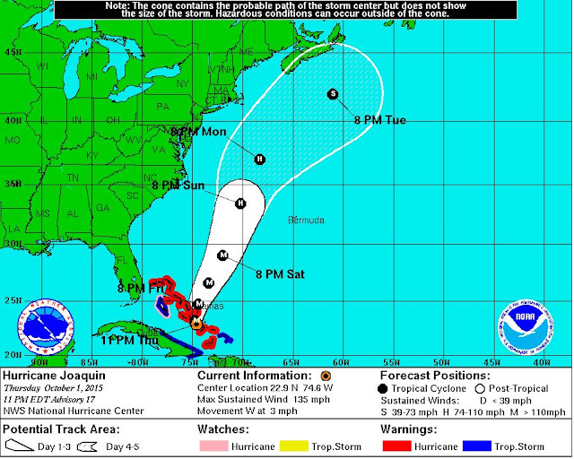
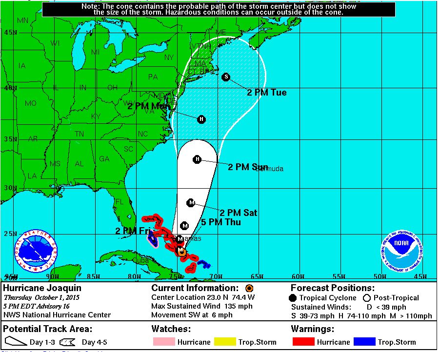
500 PM EDT THU OCT 01 2015
...EXTREMELY DANGEROUS CATEGORY 4 JOAQUIN MOVING THROUGH THE
CENTRAL BAHAMAS...
...HURRICANE CONDITIONS TO CONTINUE OVER THE CENTRAL BAHAMAS
TONIGHT...
SUMMARY OF 500 PM EDT...2100 UTC...INFORMATION
----------------------------------------------
LOCATION...23.0N 74.4W
ABOUT 15 M....25 KM NW OF CROOKED ISLAND BAHAMAS
ABOUT 70 MI...110 KM S OF SAN SALVADOR BAHAMAS
MAXIMUM SUSTAINED WINDS...130 MPH...215 KM/H
PRESENT MOVEMENT...SW OR 235 DEGREES AT 6 MPH...9 KM/H
MINIMUM CENTRAL PRESSURE...936 MB...27.64 INCHES
WATCHES AND WARNINGS
--------------------
CHANGES WITH THIS ADVISORY:
None.
SUMMARY OF WATCHES AND WARNINGS IN EFFECT:
A Hurricane Warning is in effect for...
* Central Bahamas
* Northwestern Bahamas including the Abacos, Berry Islands,
Eleuthera, Grand Bahama Island, and New Providence
* The Acklins, Crooked Island, and Mayaguana in the southeastern
Bahamas
A Hurricane Watch is in effect for...
* Bimini
* Andros Island
A Tropical Storm Warning is in effect for...
* Remainder of the southeastern Bahamas including the Turks and
Caicos Islands
* Andros Island
A Hurricane Warning means that hurricane conditions are expected
somewhere within the warning area. Preparations to protect life and
property should be complete in the central Bahamas.
A Hurricane Watch means that hurricane conditions are possible
within the watch area.
A Tropical Storm Warning means that tropical storm conditions are
expected somewhere within the warning area.
For storm information specific to your area, please monitor products
issued by your national meteorological service.
DISCUSSION AND 48-HOUR OUTLOOK
------------------------------
At 500 PM EDT (2100 UTC), the center of Hurricane Joaquin was
located near latitude 23.0 North, longitude 74.4 West. Joaquin is
moving toward the southwest near 6 mph (9 km/h), and a westward or
southwestward motion is expected through tonight. A turn toward the
north is expected on Friday, and a faster motion toward the north is
expected Friday night and Saturday. On the forecast track, the
center of Joaquin will move near or over portions of the central
Bahamas tonight and pass near or over portions of the northwestern
Bahamas on Friday.
Maximum sustained winds are near 130 mph (215 km/h) with higher
gusts. Joaquin is a category 4 hurricane on the Saffir-Simpson
Hurricane Wind Scale. Some additional strengthening is possible
tonight and Friday, with some fluctuations in intensity possible
Friday night and Saturday.
Hurricane-force winds extend outward up to 45 miles (75 km) from the
center and tropical-storm-force winds extend outward up to 175 miles
(280 km).
The estimated minimum central pressure is 936 mb (27.64 inches).
HAZARDS AFFECTING LAND
----------------------
WIND: Hurricane conditions are expected to continue across portions
of the central and southeastern Bahamas through Friday. Hurricane
conditions are expected over portions of the northwestern Bahamas
tonight and Friday. Tropical storm conditions will affect other
portions of the southeastern Bahamas, and the Turks and Caicos
Islands through tonight.
STORM SURGE: A very dangerous and life-threatening storm surge will
raise water levels by as much as 5 to 10 feet above normal tide
levels in the central Bahamas in areas of onshore flow. A storm
surge of 2 to 4 feet above normal tide levels is expected in the
remainder of the Bahamas within the hurricane warning area. Near
the coast, the surge will be accompanied by large and dangerous
waves.
RAINFALL: Joaquin is expected to produce total rain accumulations
of 10 to 15 inches over the central Bahamas with isolated maximum
amounts of 20 inches. Rainfall amounts of 5 to 10 inches are
expected over the southeastern Bahamas, with 2 to 4 inches over the
northwestern Bahamas. This rainfall could result in life-threatening
flash floods. Outer rain bands of Joaquin may affect portions of
eastern Cuba, Haiti, and the Dominican Republic today and tonight.
SURF: Swells generated by Joaquin will affect portions of the
Bahamas during the next few days, and will begin to affect portions
of the southeastern coast of the United States tonight and spread
northward through the weekend. These swells are likely to cause
life-threatening surf and rip current conditions. Regardless of
Joaquin's track, a prolonged period of elevated water levels and
large waves will affect the mid-Atlantic region, causing significant
beach and dune erosion with moderate coastal flooding likely. Please
consult products from your local weather office.
NEXT ADVISORY
-------------
Next intermediate advisory at 800 PM EDT.
Next complete advisory at 1100 PM EDT.
//-----------------------------///
HURRICANE JOAQUIN DISCUSSION NUMBER  12
NWS NATIONAL HURRICANE CENTER MIAMI FL       AL112015
500 PM EDT WED SEP 30 2015

There has been little change in the organization of Joaquin during
the past several hours.  While the hurricane continues to produce
cloud tops colder than -80C in the eyewall, the eye has not become
better defined since the last advisory.  Satellite intensity
estimates are 77 kt from both TAFB and SAB, so the advisory
intensity is now 75 kt.

The initial motion is 225/7.  The shortwave ridge causing this
motion is expected to weaken during the next 24-48 hours as a strong
deep-layer trough develops over the southeastern United States.
Thus, a generally southwestward motion is expected for the next 36
hours or so, followed by a turn toward the north as the trough
becomes the dominant steering mechanism.  There is an increased
disagreement between the GFS, UKMET, Canadian, and NAVGEM models
versus the ECMWF since the last advisory.  The ECMWF has continued
its forecast of showing a northeastward motion after 72 hours,
taking Joaquin just west of Bermuda and out to sea.  The other
models have all shifted their forecasts to the left and now
call for landfall in the Carolinas and the mid-Atlantic states,
followed by merger with the baroclinic trough.  Given the shift in
the non-ECMWF models, a major westward adjustment has been made to
the forecast track at 96 and 120 hours, bringing the center of
Joaquin near or over portions of the mid-Atlantic states.  Due to
the use of the ECMWF in the consensus models, the new track lies
near the various consensus models.  However, it lies well to the
east of the GFS and the other similar models.  The NOAA G-IV jet is
currently flying a synoptic surveillance mission, which, along with
special rawinsonde launches, hopefully will reduce the spread of the
guidance.

There is little change to the intensity forecast philosophy since
the last advisory.  Joaquin is expected to remain in an environment
of moderate northeasterly vertical shear for the next 24-36 hours,
possibly including strong winds seen at 400 mb in recent dropsondes
from the G-IV aircraft.  However, since it has been steadily
strengthening in such an environment, there is no obvious reason to
think it will stop doing so.  After 36 hours, the hurricane is
likely to move into an area of divergent southerly upper-level winds
associated with the eastern U. S. trough.  While there is
uncertainty as to how much shear should occur, it is expected that
additional intensification could occur through at least 48 hours.
Based on this, the intensity forecast calls for Joaquin to peak as a
major hurricane in 48-72 hours, and it is possible it could be
stronger than currently forecast.  After 72 hours, increasing shear,
cold air intrusion, and land interaction should cause weakening and
the start of extratropical transition.


KEY MESSAGES:

1.  Preparations to protect life and property within the warning
areas in the Bahamas should be rushed to completion.

2.  A significant adjustment to the forecast has been made this
afternoon, and this shows an increased threat to the mid-Atlantic
states and the Carolinas.  However, confidence in the details of the
forecast after 72 hours remains low, since we have one normally
excellent model that keeps Joaquin far away from the United States
east coast.   The range of possible outcomes is still large, and
includes the possibility of a major hurricane landfall in the
Carolinas.

3.  Every effort is being made to provide the forecast models with
as much data as possible.  The NOAA G-IV jet has begun a series of
missions in the storm environment, and the National Weather Service
is launching extra balloon soundings.

4.  Because landfall, if it occurs, is still more than three days
away, it is too early to talk about specific wind, rain, or surge
impacts from Joaquin in the United States.   Even if Joaquin stays
well out to sea, strong onshore winds will create minor to moderate
coastal flooding along the coasts of the mid-Atlantic and
northeastern states through the weekend.

5.  A hurricane watch for a portion of the U.S. coast could be
required as early as Thursday evening.

6.  Many areas of the eastern U.S. are currently experiencing heavy
rains and gusty winds associated with a frontal system.  This
inclement weather is expected to continue over the next few days,
which could complicate preparations for Joaquin should it head
toward the coast, and greatly exacerbate the impacts from the
hurricane.  Heavy rains are likely to continue over these areas
even if the center of Joaquin stays out to sea.


FORECAST POSITIONS AND MAX WINDS

INIT  30/2100Z 24.3N  73.1W   75 KT  85 MPH
 12H  01/0600Z 24.0N  73.8W   85 KT 100 MPH
 24H  01/1800Z 23.9N  74.5W   90 KT 105 MPH
 36H  02/0600Z 24.5N  75.0W   95 KT 110 MPH
 48H  02/1800Z 25.8N  75.0W  100 KT 115 MPH
 72H  03/1800Z 30.5N  74.5W  100 KT 115 MPH
 96H  04/1800Z 36.0N  75.5W   85 KT 100 MPH
120H  05/1800Z 38.5N  76.5W   55 KT  65 MPH


