


Risk of flooding rainfall to shift as Gordon's moisture is drawn over Midwest
By Alex Sosnowski, AccuWeather senior meteorologist
September 05, 2018, 1:13:16 PM EDT
As the weather pattern evolves into the weekend, the swath of torrential downpours and risk of flooding in the Midwest will shift southeastward as moisture from Gordon is drawn in.
Downpours will continue the threat of urban, small stream and river flooding from parts of the central Plains to the western Great Lakes region into Thursday.

In the last seven days, parts of the region have received 5-10 inches of rain with rainfall in some areas topping 15 inches during the past two weeks.
On Tuesday evening, portions of southeastern Minnesota and western Wisconsin picked up as much as half a foot of rain.
Into Thursday, there is the potential to add another 1-5 inches of rain on top of what has already fallen. Enough rain is likely to fall to keep stream levels high and may lead to a second crest on some area rivers.
However, some changes are in store later this week, which will allow the weather to improve in some locations and turn very wet in others. Some locations caught in the middle of another surge of moisture will be hit with more rain.
A punch of dry air is forecast to end the rounds of torrential rain in portions of Wisconsin, southern Minnesota and northern Michigan spanning Thursday and Friday.

Much of Iowa and eastern Nebraska may dry out, but only for a brief time.
That dry press will only advance so far over the Plains and Midwest before the combination of a non-tropical storm and moisture from Gordon intervene.
From later Friday and through the weekend, the non-tropical storm and Gordon's tropical downpours are likely to become intertwined and push northeastward from the southern Plains and middle Mississippi Valley to portions of the Ohio Valley, lower Great Lakes and the interior Northeast.

"This swath of heavy rain will extend from Arkansas and eastern Oklahoma to eastern Kansas, central and northwestern Missouri, eastern Nebraska, southern Iowa, the southern tier of Michigan to the northern portions of Illinois, Indiana and Ohio," according to AccuWeather Lead Long-Range Meteorologist Paul Pastelok.
"Within the swath related to Gordon alone, a general 2-4 inches of rain is likely with an AccuWeather Local StormMax™ of 6 inches spanning Friday to Sunday," Pastelok said.
On its own, this is enough rain to cause urban and small stream flooding. Where the rain overlaps the excessive rainfall in the past two weeks over the Plains and Midwest, a new round of river flooding may result.
People with flexible outdoor plans on the Plains may want to choose Sunday for their activities. Both days of the weekend may be unsettled in parts of the Midwest including for high school, college and professional football games.
From Sunday to Monday, the heavy rain will swing across the eastern Great Lakes and interior Northeast. In this area, a general 1-2 inches of rain is forecast with local amounts to 4 inches possible in 12 to 24 hours.
Forward speed will limit the risk of flooding in the Northeast. However, urban flooding is likely with the potential for small stream flooding.
While much of Ohio Valley, mid-Atlantic and southern New England area may be south of the heaviest rainfall, there is the potential for a couple of showers and a gusty thunderstorm as the storm passes through.
A few locally severe thunderstorms cannot be ruled out as these locations will be on the warm, tropical side of the storm.
The best bet for outdoor plans this weekend in the Northeast will be on Saturday and perhaps the first part of Sunday.
====================================
By DeMarco Morgan CBS News September 3, 2018, 6:54 PM
"In survival mode": 500-year rains leave much of Midwest underwater
Much of the Midwest is underwater from relentless rain storms, as Tropical Storm Gordon pounds South Florida and the Keys with high winds and up to five inches of rain.
The rains were a once-in-500-year event that quickly turned towns into lakes in Riley County, Kansas.
"It was one of the most significant events that we have experienced," said Ron Fear, the city manager of Manhattan, Kansas. "Things got flooded this time that never got flooded before."
Hundreds had to be rescued by boat there when Wildcat Creek flooded 21 feet above crest. Jacob Weiner escaped just in time.
"Just trying to get all my belongings together," Weiner said. "But I didn't have enough time. Just took baby and dog, wallet and keys and that's it."
More than 300 people have been displaced.
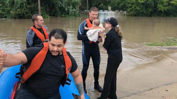
Manhattan, Kansas residents flee rising waters.
CBS News
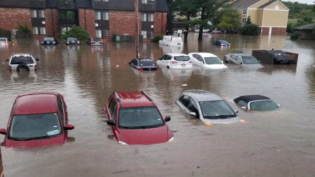
Floodwaters have ravaged homes and businesses in the area, leaving cars submerged in rising waters. Hundreds are still without power.
"Right now they are in survival mode. Whatever they could carry out on a boat in a bag, 1 or 2 bags, has been kind of the state of mind here," said Jason Hudson of Manhattan Fire and Rescue.
Wisconsin is seeing its second-wettest August on record with emergency officials putting the damage at $44 million.
CBS News
Three tornadoes even touched down in Michigan, destroying everything in their path.
That same system was enough for officials to cancel the football game at the University of Nebraska's football stadium in Lincoln, the first time in school history.
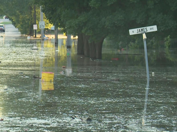
Flood warnings continue in the waterlogged Midwest, some all the way until Thursday. And it's only Monday.
==============================
ens of millions face flooding threat across Midwest
Share
Tweet
More heavy rain is coming to the Midwest, an area already waterlogged after powerful weekend storms. Tens of millions face the threat of flooding, with forecasters predicting the storm system will stall over the region.
At least six states are under flood watches or advisories.
Iowa has been especially hard-hit, with nearly one-third of the state under a flash flood watch through Monday afternoon.
There were multiple tornadoes over the weekend in Michigan, and parts of Wisconsin have gotten more than 14 inches of rain over the past two weeks, reports CBS News correspondent Tony Dokoupil.
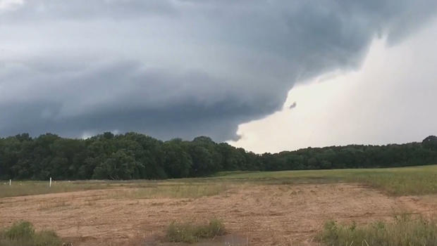
Tornadoes were reported in three Michigan counties this weekend.
CBS News
Flooding has caused an estimated $50 million in damage so far, and now there's more rain on the way.
Still reeling from days of damaging weather, this weekend capped off the second wettest August on record in Wisconsin.
"It's heartbreaking to see the damage," said Governor Scott Walker, who toured one of the hardest-hit counties Friday after declaring a statewide emergency last week.
Severe flooding in Wisconsin.
CBS News
The National Weather Service confirmed at least 3 tornadoes touched down in three different counties in Michigan, including in Barry County, where a twister snapped a huge tree and brought it crashing down on one home.
"It didn't sound like a freight train or whatever they say; it just sounded like a real huge wind," one witness said.
In Lincoln, Nebraska, the skies opened up Saturday night over Memorial Stadium at the University of Nebraska. The delay turned into a cancellation, marking the first time in school history a football game was canceled because of weather.
In Pennsylvania, Lancaster and York Counties are cleaning up after heavy downpours left a destructive mark in the region. Officials in both counties issued disaster declarations after multiple roads were damaged during the storm.
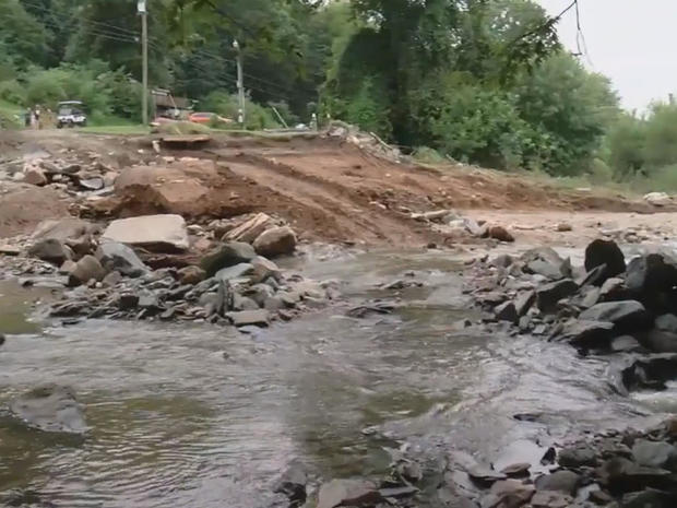
Destruction from flooding in Pennsylvania.
CBS News
"I was amazed, actually, because it has rained harder than that here and we've never had this kind of destruction," said one woman amidst the destruction.
In Mount Joy, where more than nine inches of rain fell over a three-hour period on Friday, damage assessments revealed some harsh realities.
"Every bit of her furniture is out here," said resident Connie Guy. "She lost everything that gives her quality of life."
Forecasters say tropical air from the Gulf of Mexico will add to the intensity of the downpours and may bring more than a month's worth of rain to some areas.
Meanwhile, the Gulf Coast is being told to watch out for Tropical Storm Gordon.
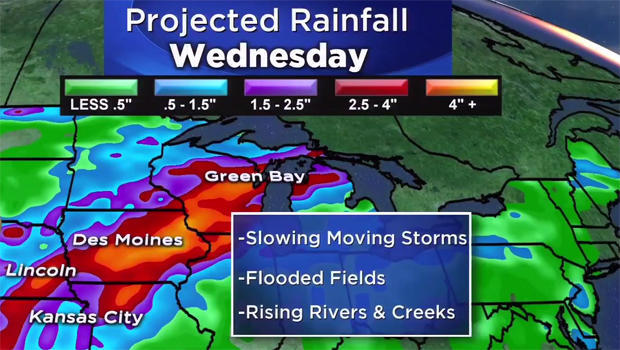
Meteorologist Danielle Niles of CBS' Boston station WBZ has been tracking the storm and the flood threat in the Midwest, both of which are going to have major impacts over the next several days.
On Monday morning there are flash flood watches and warnings from Kansas to Nebraska, stretching to portions of Iowa and northern Illinois.
"The renewed risk of flooding and additional rainfall over the next couple of days is on the order of 4 to 8 inches," said Niles. "Flooded fields, rising rivers and creeks are going to be a major concern with a significant impact there through Wednesday at least."
CBS News
Meanwhile, the threat along the Gulf Coast from a likely tropical storm means rain from Mississippi down through Louisiana as well as storm surge depending upon the exact track of the storm. Tropical warnings up are up from Mobile, Ala., through Biloxi and New Orleans, down through Port Sulphur, and towards the central Louisiana coastline.