Storms are moving in, and could cause street flooding.
Wednesday, June 01, 2016 01:05PM
HOUSTON (KTRK) -- Storm chances are on the rise as a slow-moving weather system meanders through Texas the next several days.
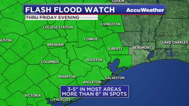
A Flash Flood Watch is in effect through Friday evening for Austin, Brazoria, Brazos, Burleson, Chambers, Colorado, Fort Bend, Galveston, Grimes, Harris, Houston, Jackson, Liberty, Madison, Matagorda, Montgomery, Polk, San Jacinto, Trinity, Walker, Waller, Washington and Wharton counties.
The rest of the afternoon will feature scattered showers and storms. The storms should be moving fast enough to keep major from happening. Rain chances will climb even more Thursday and Friday as the main storm system gets closer to Houston. Some of these storms may become severe with damaging winds the main threat. Periods of heavy rain and frequent cloud-to-ground lightning strikes are likely with each wave of rain.
The storm will stay over Texas through the weekend, bringing multiple rounds of heavy rain. Timing the rain is difficult in this weather pattern, so we'll all need to monitor MegaDoppler radar closely the next several days. We'll also be keeping a close eye on the local rivers that are still in major flood stage: Brazos, Colorado, and Trinity.
Stay weather-aware this week. Download the free abc13 weather app to check the radar while you're out and about.