California out of 'exceptional drought' category after recent storms
(Left) A map of California from the United States Drought Monitor. (Right) A car drives through a flooded street in Van Nuys on Sunday, Jan. 22, 2017. (United States Drought Monitor | AP Photo/Richard Vogel)
Updated 52 mins ago
LOS ANGELES (KABC) -- The series of powerful storms to recently douse California has lessened the state's drought.
According to the U.S. Drought Monitor, the worst level of drought -- "exceptional drought" -- has been entirely erased from California for the first time in three years.
Just 2.16 percent of the state is in "extreme drought," the group states.
The U.S. Drought Monitor map indicates the 2.16 percent includes portions of Santa Barbara, Ventura, Kern and Los Angeles counties.
At its height, nearly 60 percent of the state was under "exceptional drought."
During this wet season, Los Angeles has received 216 percent of normal rainfall to date.
Despite this, California's top water regulator is not ready to lift emergency conservation measures enacted during the height of the drought.
"It makes the most sense to continue steady as she goes," State Water Resources Control Board chairwoman Felicia Marcus told The Associated Press after the latest in a series of storms brought more snow to the mountains and record-breaking rainfall to parts of the Southland.
Marcus and the other four board members will decide Feb. 7 whether to extend measures requiring local water districts to enforce conservation rules, provide monthly reports on water usage and show they have a three-year water supply.
January typically is the wettest month in California. Marcus said in interviews this week that she is concerned that subsequent months could turn out dry and that California could again be forced to scramble to save water if the restrictions are not kept in place.
California has endured more than five years of drought. In January 2014, Gov. Jerry Brown declared an emergency, later ordering residents statewide to cut water use by 25 percent - the first mandate of its kind in the state's history.
 .
.
CeFaan Kim, Eyewitness News
Thursday, January 26, 2017 10:03AM
FLUSHING, Queens (WABC) -- The fire that ripped through a row of businesses in Queens Wednesday was accidental, FDNY fire marshals said Thursday.
Investigators say it was sparked by a stove fire, caused by cooking.
Firefighters battled the large fire Wednesday afternoon and into the night in a shopping district that spread to at least 15 stores.
The fire broke out at about 2 p.m. on Roosevelt Avenue near the intersection of Main Street in Flushing. It took until after 8 p.m. for the fire to be extinguished.
The fire generated a four-alarm response.
Fire officials said there was a partial collapse of the rear roof.
"This is a difficult fire, a lot of smoke. Pockets of fire travel to different occupancies," said Chief Joseph Pfeifer, FDNY.
Here's a look at photos showing flames shooting from the roof:
PHOTOS: Large fire in Flushing, Queens


Fire officials said the fire was in the duct work of the building, and that's how they believe it spread to the second building and beyond.
Witnesses described a genuine fear for firefighters safety. It took more than 175 of them to get the blaze under control. A store sign collapsed just moments after they entered the building.
"Just shock. They're inside and the fire is just getting bigger. So I was afraid for them," said Chris Urban, a witness. "And then they were getting the saw and cutting the sign as fast as possible."
Three firefighters are being evaluated at the hospital for minor injuries.
"These are local mom and pop stores, it's absolutely heartbreaking. It's not just the owners. There are dozens if not hundreds of workers at these 15 stores. These are working families, everyday people that rely on those jobs to put food on the table. So they're nervous, they're scared," State Assemblyman Ron Kim said.
The fire disrupted service on the 7 train line for hours, but it resumed service with delays just before 11:30 p.m. Several buses remain detoured, including Q48, Q12 and Q15.
Here's video from the Eyewitness News reporter CeFaan Kim at the scene:
Officials say the timing of the fire was especially bad, coming less than two weeks before the community celebrates the Lunar New Year.
It's a celebration that usually brings a big economic boost to the neighborhood.
(@nycfirewire )
Eyewitness News
Tuesday, January 24, 2017 11:36PM
PROSPECT LEFFERTS GARDENS, Brooklyn (WABC) -- Dozens of residents were evacuated from burning apartment building in Brooklyn on Tuesday night.
The fire stated between the roof and the ceiling of the six-story building on Winthrop Avenue in Prospect Lefferts Gardens around 8 p.m.
The three-alarm fire then spread to the front of the building. Firefighters had to cut holes into the roof of the building to extinguish the fire.
Fortunately, no one was injured, but some 100 residents were evacuated from the building.
It's not yet known when they can return to their apartments. The Red Cross is on the scene assisting displaced residents.
"Brooklyn *77-22-1092**2nd Alarm** 35 Winthrop St off Flatbush Ave. Fire
top floor 6 story non-fireproof, extended to the cockloft" Source: @nycfirewire
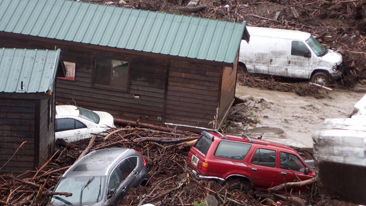
Trough five years of severe drought, El Capitan Canyon above the Pacific Ocean near Goleta endured bone-dry conditions that at times seemed like they would never end.
Then, on Friday, the skies opened up. Nearly 2 inches of rain dropped in a single hour in the Santa Ynez Mountains.
So a creek that had once disappeared came roaring alive, full of mud, brush and broken trees pouring from the burned slopes of the Sherpa fire in the summer.
Five cabins were lifted off their foundations and swept down the creek. The muddy torrent claimed 22 vehicles. One of the cabin’s remains were found south of the 101 Freeway. Nearly two dozen people had to be rescued, including one trapped in a car, said Santa Barbara County fire Capt. Dave Zaniboni. The remains of five smashed vehicles floated all the way down to the beach.
What happened in a matter of minutes at the campground is emblematic of the drought-to-deluge cycle that has always been at the heart of California’s climate. All it can take is an intense amount of rain in a short amount of time to create damaging flows of mud and debris that can kill people and destroy buildings.
The flows are part of nature. But the situation has become more dangerous as humans came to inhabit these paths of destruction.
“There’s a competition between the growth of the mountains and the erosion from the rainstorms,” U.S. Geological Survey hydrologist Jason Kean said. “They’re in this constant battle.”
Flood waters and a debris flow sweep away cabins and vehicles at El Capitan Canyon Resort & Campground in Santa Barbara County Friday. (Mike Eliason / Santa Barbara County Fire)
California’s dramatic shift in the last few months — from extreme dryness to some of the strongest storms in a decade — has brought mudslides that have closed roads, damaged vehicles and homes and left residents on edge. On Friday night, Highway 17 — the key route between Silicon Valley and Santa Cruz — was closed for hours after sliding mud and a fallen tree blocked all southbound lanes, causing a commuter nightmare.
One Sierra highway alone has endured nearly 20 major slides. And a rare warm winter storm two weeks ago sent rains that deposited 10,000 cubic yards of decomposed granite that shut down all westbound lanes of Interstate 80 west of Lake Tahoe for more than 12 hours.
“It’s truly a battle,” Caltrans spokeswoman Liza Whitmore said.
The situation is expected to get worse in Southern California on Sunday, when a storm — which could be the most powerful to strike the region since 2010 — moves in. Officials have warned of mudslides and mudflows.
Why do landslides happen during a storm?
In a burned area, a wildfire can make the soils repellent to water, creating a floodlike flow on the ground that picks up rock and debris, Kean said.
In an area that has not burned, soil can become saturated. Pressure builds up underground, and soil starts moving and begins picking up mud and debris as it starts flowing downhill.
Water rushing down with only mud is called a mud flow. If the flow picks up rocks, branches and sometimes massive boulders, that’s called a debris flow.
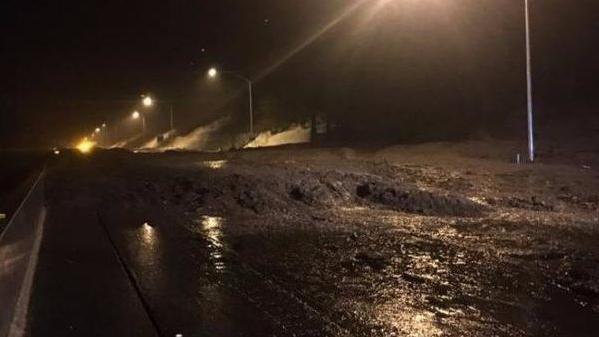
This debris flow on Jan. 8, 2017 was caused by a warm winter storm that dumped rain on the Sierra, sending a flow of water and decomposed granite to wash over Interstate 80 at Donner Summit. (California Highway Patrol)
Mud and debris flows are types of shallow landslides, generally defined as less than 15 feet deep.
Another type of shallow landslide involves a saturated hillside that collapses but does not move very far, such as one that buries a roadway with dirt and rocks from a neighboring slope. They can happen up to an hour after a burst of intense rain. “There were widespread shallow landslides as recently as 2005” in Southern California, Kean said.
What’s the easiest type of landslide to predict?
Landslides that strike in recently burned areas are the easiest to predict, as wildfires have burned away roots of trees and vegetation that had kept soils in place.
Sometimes, authorities have accurately predicted when debris flows will occur, based on forecast rainfall rates, and have called for evacuations of homes before the rivers of mud and debris begin flowing.
Can debris flow still catch people off guard?
Yes. In 2010, the winter after the worst fire in L.A. County history, a debris flow — which one resident described like a “Niagara Falls” — flowed down La Cañada Flintridge’s northernmost neighborhood when a 10-ton boulder clogged a critical basin, plugging up the drain like a giant stopper. More than 40 homes were damaged.
It came as a surprise because the storm was supposed to be fast moving, but unexpectedly stalled and dumped rain at an alarming rate. The forecast that authorities had relied on in the days leading up to the three-day storm had called for a light to moderate rains. No evacuations had been ordered.
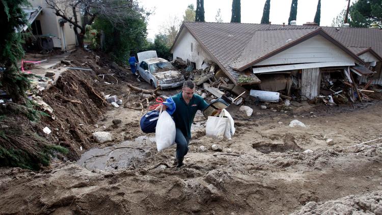
A debris flow hit La Canada Flintridge in 2010. Mud and debris came rushing through an entire house on Manistee Drive. (Allen J. Schaben / Los Angeles Times)
How much rainfall is needed to trigger mud or debris flow?
In Southern California’s unburned areas, 10 inches of rainfall during the winter is needed to nearly saturate the ground. After that point, a burst of rain of just one-quarter of an inch an hour can trigger widespread shallow landslides, including debris flow, Kean said.
Since July 1, downtown Los Angeles has received 11.33 inches of rain as of Friday, which is 178% of average at this point of the winter. Santa Barbara has received 12.03 inches, which is 149% of average.
But for burned areas, mud and debris flows can strike with only intense rainfall, even if the ground is not saturated.
What’s the least predictable type of landslide?
The kind that can strike on a dry day.
In areas where the bedrock is very deep, rainwater can seep deep underground during multiple rainstorms. During a series of repeated heavy storms, water can eventually start to accumulate and build up pressure, Kean said.
The pressure can destabilize an entire chunk of land, causing it to collapse downhill. The landslide can happen slowly, and show warning signs like cracking or subtle movements, allowing people time to escape. But they can also strike rapidly with no warning, even on a rainless day months after the end of winter.
This is called a deep-seated landslide, involving landslides greater than 15 feet deep. Often, deep-seated landslides strike in areas with a history of such events. The USGS has warned that such landslides can become active many months after a very wet winter.
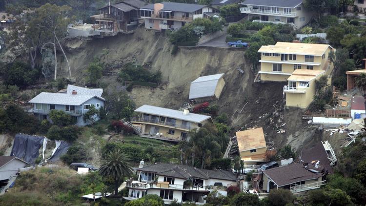
A deep-seated landslide struck Bluebird Canyon of Laguna Beach in 2005. (Mark Boster / Los Angeles Times)
What’s an example of a deep-seated landslide?
An example of where a deep-seated landslide has occurred is Bluebird Canyon of Laguna Beach.
One occurred on a foggy morning in June 2005 after heavy rains fell between the previous December through February. No rainfall occurred during or just before the landslide. Seventeen homes were destroyed and 11 seriously damaged.
There has been a history of devastating landslides in Bluebird Canyon. The neighborhood suffered a slide in October 1978 that destroyed more than 20 homes. The California Division of Mines and Geology said the heavy rains between December 1977 through April 1978 are believed to have played a role, along with a history of landslides and erosion at the site, and weakness in the rock.
What about the coastal hamlet of La Conchita in Ventura County? Did landslides there come as surprises?
The first landslide, in March 1995, came as no surprise, Ventura County geologist Jim O’Tousa said. The summer before, officials had observed ground cracks and other signs of a pending landslide. A sheriff’s official was assigned to patrol the area, and town meetings were held to prepare the community for what was coming.
Then about 24 inches of rain hit the region in January — way above the average of about 4 inches for that month. The slide hit March 2. The slopes started sliding at a pace so slow that residents could outrun it. The patrol officer was still knocking on doors as the ground was moving and got everyone down the hill in time, O’Tousa recalled.
“The groundwater finally built up to a high enough level to destabilize the slope,” O’Tousa said.
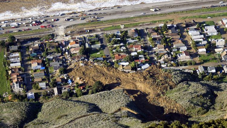
A deep-seated landslide buried 10 people, killing them, in 2005 in La Conchita. (Stephen Osman / Los Angeles Times)
The second landslide in 2005 occurred at the end of an intense 15-day rainy period that saw heavy precipitation throughout Southern California. This slide came with no warning, and buried 10 people, killing them.
The 2005 landslide was actually a “remobilization of part of the 1995 slide,” O’Tousa said. The 1995 landslide had fractured and was sitting in the bottom of the canyon, he explained. Then in 2005, when enough water saturated the bottom of the canyon, the material came flushing out of the canyon — a speed of 20 mph — and flowed into the neighborhood where the fatalities occurred.
What about cliffs that fall into the sea?
Last winter, California saw cliffs erode into the sea in Pacifica, about a 15-mile drive south of San Francisco. There, apartment units have been ordered vacated because of the crumbling coastline.
Pacifica has some of the weakest soils along the California coast composed of cliffs, USGS research civil engineer Brian Collins said.
The cliffs are being attacked from both the bottom and on top from water. At its base, the ocean is eroding the cliffs. When heavy rains come from above, water seeps into the soils, and eventually exits when it reaches less permeable layers.
The nature of this seepage weakens the bonds in the soil that keep the soil particles bonded together, “so it collapses,” Collins said.
The coast in this region has been eroding for thousands of years. As sea levels have risen, the ocean has eroded the cliffs. And the San Andreas fault has been lifting the cliffs up, only for them to be taken down by the seas and the rain.