MEC&F Expert Engineers

Monday, October 3, 2016

Police slams a handcuffed man's face into the windshild of their cruiser so hard that the windshield cracked; police claim he was resisting arrest in Lorain, Ohio; the Feds are suing the police.


Dashcam video shows officers crack windshield with suspect's face


Newly released dashcam footage from a 2014 arrest raises questions about use of force at one Ohio police department. (KTRK)

Monday, October 03, 2016 09:16AM
LORAIN, Ohio -- During a 2014 arrest, a man was slammed against a police cruiser so hard his face cracks the windshield, according to newly released video that is part of a federal lawsuit against an Ohio police department.

Officers, however, say the video only tells part of the story.

"Disturbing. Shocking. I think it's kind of difficult to watch," remarked defense attorney Mark Petroff, who represents 30-year-old Pele Smith, the man whose face was slammed against the windshield by officer Zachary Ferenec so forcefully that the glass shattered.

"I don't know what type of force it takes to break a windshield, but i would imagine it's pretty substantial," Petroff told WEWS-TV.

During the altercation, Smith's chin made impact with the vehicle. He went to the hospital, but did not need stitches.

Smith was being arrested over suspicions of drug trafficking, for which he has been convicted before.

A police spokesman was advised by city lawyers not to speak on-camera, but said off-camera that officers had to use greater force because Smith was resisting arrest. They said the slam was not intentional.

"It's not an accident. You watch the video and you certainly will form the same opinion. In fact, it looks like he was lifted up and slammed into the windshield," adds Petroff.

Smith is suing the department for monetary damages.


======


LORAIN, Ohio - Newly released dashcam video shows an officer in Ohio slamming a handcuffed suspect onto a police cruiser with such force that the man's face shattered the windshield.

32-year-old Pele Smith has filed a civil rights lawsuit against the city of Lorain, accusing several officers of excessive force.

"It’s unbelievable, it’s sad, it’s frightening that an individual, while in handcuffs, has something like that happen to them,” said Mark Petroff, Smith's attorney.

Though the dashcam video was just released, the incident happened back in September of 2014.

Officers were investigating a neighborhood for drug offenses when they stopped Smith for jaywalking.

According to WKYC, Smith had previously been convicted on drug charges and for possessing a firearm.

An officer at the scene believed Smith swallowed some drugs, and then say he became uncooperative.

Lorain Police Chief Cel Rivera released a statement to WKYC, stating that the video could be misunderstood and does not tell the whole story, asking people to not rush to judgement. "Although it is not easy to watch, police officers explain all of their actions in their police reports," the statement reads.

As part of a plea deal, Smith received probation after pleading guilty to charges of tampering with evidence, obstructing official business, and resisting arrest.

A speeding and reckless female driver was critically injured after rear-ending the parked Paramedic Engine E-94 on Interstate 15 near Wildomar, California


The driver of the vehicle suffered extensive injuries and required extrication from the mangled vehicle. Photo credit: CAL FIRE/Riverside Fire


A woman was seriously after crashing into a pumper on Interstate 15 near Wildomar.

CAL FIRE/Riverside Engine 94 responded along with American Medical Response and the California Highway Patrol responded to a crash the interstate near Railroad Canyon at 7:04 a.m.

While crews were treating a patient at the crash scene, a vehicle slammed into to the back of the pumper.

Firefighters had to extricate the driver of the vehicle, according to a statement from CAL FIRE/Riverside County Fire.

The driver sustained serious injuries and was transported to the hospital by American Medical Response.

No firefighters were injured.

The California High Patrol is investigating the cause of the collision.


======


WILDOMAR: Fire engine on emergency call struck by motorist on I-15
October 2, 2016 Trevor Montgomer


The Chevrolet that smashed into the fire engine was completely destroyed in the collision. IE Firefighter photo

WILDOMAR – A Cal Fire/Riverside County fire engine sustained major damage while working on a traffic collision call when it was struck by a vehicle on Interstate 15 in Wildomar Sunday morning, Oct. 2.

Firefighters were providing medical aid for those injured in the first collision when it was struck from behind. The first accident was reported just before 7 a.m.

Paramedic Engine E-94 from the City of Lake Elsinore’s Canyon Hills Fire Station 94 was parked on the right side of the freeway in a position to provide protection for firefighters as they worked.

While firefighters were working with the victims injured in the first collision a Chevrolet HHR traveling at high-speed smashed into the back end of the rig, according to Cal Fire/Riverside County Fire Department officials.


Paramedic Engine E-94 sustained major damage in the rear end collision. Tommy Voegele photo

The two accidents happened on the freeway near the Olive Street underpass, which is south of Railroad Canyon and north of Bundy Canyon Roads

The second collision – that occurred at about 7:25 a.m. – caused a Sig Alert that shut down all southbound lanes of freeway traffic for several hours, according to a California Highway Patrol incident log.

16 firefighters from three engine companies and one truck company as well as a fire investigator and three battalion commanders responded to the scene after the accident involving the fire engine, according to Cal Fire/Riverside County Fire Public Information Officer Jody Hagemann.

The driver of the Chevrolet that struck the fire engine was trapped inside their vehicle and had to be extricated from his wrecked vehicle. Paramedics treated the victim at the scene before they transported him by ground ambulance to a nearby hospital. The victim sustained major injuries, according to Hagemann.


The Chevrolet was unrecognizable after the accident. Tommy Voegele photo

“(This is) a reminder of why we use our apparatus as a barrier on emergency incidents,” Cal Fire/Riverside County Fire Department Unit & Fire Chief John Hawkins wrote after the traffic collision.

As a precautionary measure one firefighter was taken to a hospital for evaluation, according to Hawkins.

Canyon Hills Station 94 is located on Railroad Canyon Road just outside the community of Canyon Hills. The station serves the southeast area of the City of Lake Elsinore, portions of Wildomar and Canyon Lake. Paramedic Engine 94 was the stations primary engine before it was destroyed in the collision.

Tommy Voegele, a tow truck driver who responded to the accident scene, later wrote on social media, “This morning, these firefighters were just doing their jobs and helping some people who got into an accident when another car hit the back of their fire truck.”

“The driver of the Chevrolet hit the fire engine so hard his motor flew out of his car and landed about 100 feet away,” Voegele explained. “Everyone needs to open their eyes and pay better attention.”


The impact was so severe the Chevrolet’s engine was thrown over 100 feet after the collision. Tommy Voegele photo

“It’s easy,” Voegele explained, “just slow down and move over for emergency vehicles, police officers and tow trucks.”

“Luckily, none of the firefighters where seriously injured,” Voegele said.

The I-15 on-ramp at Railroad Canyon Road was reopened at about 9:30 a.m. All other lanes of traffic were reopened just before 11 a.m.

California High Patrol officers are investigating the cause of the collision. Officers have not yet ruled out alcohol or drug intoxication as contributing factors in the collision.

KILLING THEM SLOWLY: Illegal trade is accelerating the extinctions of wild plant species, and more transparent value chains would help tackle this illegal trade


Transparency Needed to Curb Illegal Plant Trade


By MarEx 2016-10-02 19:15:30

Illegal trade is accelerating the extinctions of wild plant species, and more transparent value chains would help tackle this illegal trade, an UNCTAD official said on Friday on the sidelines of the world's largest conference on the wildlife trade.

Worth up to $258 billion, the illegal wildlife trade is often more associated with poached elephants than stolen orchids, but rare plant species are being increasingly stolen from the wild and sold for their beauty or medicinal properties. Besides robbing the earth of its natural resources, this illegal trade deprives communities of livelihoods, and governments of income. The United States alone seizes around 5,600 illegally trafficked plants a year.

"We know this is a substantial problem," says Lorena Jaramillo, an economist with UNCTAD's BioTrade Initiative. "We see wild species disappearing and we know they're being illegally harvested, but it's hard to trace them without full visibility along the value chains."

Some 30,000 plant species are now protected by CITES, the Convention on International Trade in Endangered Species of Wild Fauna and Flora, whose members are meeting from 24 September to October 4 in Johannesburg.

To support the discussions, UNCTAD prepared two studies in consultation with the CITES Secretariat and member countries. The first study looks at ornamental plants, including orchids and Cycas from Latin America. The second looks at medicinal plants, such as agarwood, from the Mekong subregion.

"Wild plant species are difficult to distinguish from those which are legally grown in nurseries. This makes it hard to prevent the "laundering" of illegally sourced plants, especially in the traditional medicine market, whose value chains can be long and complex," says Jaramillo.

Researchers found significant inconsistencies in data on exports and imports. These discrepancies, for example, represented almost 20 percent of the orchid trade and 33% of the trade in Cycas from the Andean region for the period 2010-2014. In the case of agarwood, used for pricey perfumes and traditional Chinese medicines, Laos reported no exports during the period 2005-2014, yet over 15 tons of Lao agarwood showed up in the imports and re-exports of other countries.

"It's hard to say with certainty what's going on," Jaramillo says. "The missing data may represent illegal harvest, but they may also show simply that data is being reported differently."

"What the studies do show, though, is the urgent need for a clear, common traceability framework, with uniform information, to avoid a proliferation of systems which may not be compatible," Jaramillo adds.

The studies also call for more attention on domestic supply chains. Laundering illegally harvested species is easiest in the earlier stages of the value chains, when the plants change hands before export.

HURRICANE MATTHEW: The slow-moving nature of the hurricane will translate to days rather than hours of pounding surf, high winds and heavy rain on the islands


Powerful Hurricane Matthew to unleash life-threatening flooding in Haiti, Cuba and Bahamas
 
By Alex Sosnowski, AccuWeather.com Senior Meteorologist
October 3, 2016; 9:49 AM ET

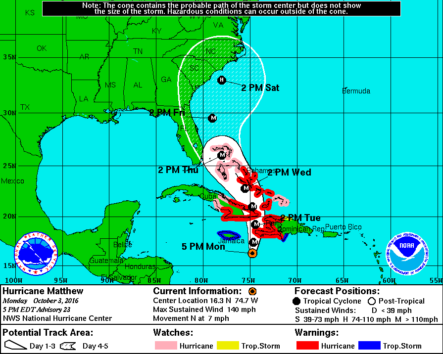
Dangerous Hurricane Matthew will bring great risk to lives and property from Haiti and Cuba to the Bahamas this week.

Matthew will continue to weave a general northward path around the large islands of the northern Caribbean through Wednesday.


"Fluctuations in strength, ranging from Category 4 to Category 2 status are likely as the hurricane is influenced by the mountainous islands and other atmospheric conditions," according to AccuWeather Hurricane Expert Dan Kottlowski.

The powerful hurricane will pass close to or directly over the western tip of Haiti and the eastern tip of Cuba. In these areas, life-threatening conditions are likely, since the most powerful part of the hurricane will approach. Impacts will range from flooding rainfall and storm surge flooding to mudslides, high winds and dangerous seas and surf into the middle of the week.


However, flooding rainfall and mudslides will extend 100 miles or more to the east of the storm over the mountainous terrain of Hispaniola and can occur as far west as Jamaica and central Cuba. Drenching, gusty squalls can occur as far east as Puerto Rico.

The latest indications are that Matthew will take more of a northwestward path beginning around Wednesday and continuing through Friday.

"Beyond the large islands of the Caribbean, much of the Bahamas are likely to be in the direct path of Matthew from Wednesday into Friday," Kottlowski said.


The Turks and Caicos may also face significant impacts by the hurricane as it passes to their west.

The slow-moving nature of the hurricane will translate to days rather than hours of pounding surf, high winds and heavy rain on the islands. More than 20 inches of rain can fall near and east of the center of the storm, especially over mountainous terrain.

People are encouraged to make preparations now and heed evacuation orders as they are given.

Great disruption to travel will also occur in the region.

Cruise, freight and charter airline interests in the region should be prepared to change itineraries until the storm has passed. Commercial airline delays and cancellations are likely as the storm approaches.

Many of these areas will be in need of assistance in the wake of the storm. Power may be out for days. Food, fresh water and medical items may be in short supply following the storm.

As Matthew turns northwestward across the Bahamas, seas and surf along the coast of the southeastern United States will build and become dangerous later this week. How serious conditions become this weekend and beyond in the U.S. will depend on the path Matthew takes.

Tracking Hurricane Matthew and its Projected Path


Hurricane Matthew upgraded to category 5 storm


Could Hurricane Matthew impact North Carolina?


By Don Schwenneker
Monday, October 03, 2016 09:11AM
RALEIGH (WTVD) -- As Hurricane Matthew, a potentially devastating Category 4 storm, swirls across the Caribbean, many are wondering if it could impact North Carolina.


The speed of a frontal boundary headed our way will determine whether Matthew comes to visit here in the Tar Heel State. The latest plot from the WPC brings a cold front through Saturday into Sunday. That would be GREAT news because that front would push Matthew out into the ocean.


Latest from @NWSWPC shows cold front through on Sunday AM pushing Matthew away. Still a long A LOT of uncertainty. #watching pic.twitter.com/NbGVRZ0Eb3— Don Schwenneker (@BigweatherABC11) October 3, 2016


Some models show the storm hundreds of miles offshore. That would be the best solution but this far out it's all speculation.

Still, the Outer Banks could see some problems even it stays out to sea. And I wouldn't plan on going in the water at the beaches this weekend. Rip currents will be a problem Friday, Saturday, and Sunday.

We'll have a much better idea on the path northward by Wednesday. By then, the storm will have passed over Cuba and that could significantly impact the northward path.
==============
Updated 33 mins ago
RALEIGH -- Hurricane Matthew is strengthening in the Caribbean and is expected to begin turning north over the weekend.

Rain and winds from the storm whipped at Aruba, Bonaire and Curacao early Friday as it passed north of the islands on a track through a part of the Caribbean that rarely sees such storms.

At 11 a.m Friday, the center of of the storm was located near latitude 13.7 North, longitude 70.8 West and moving toward the west-southwest near 12 mph. A westward motion at a slower forward speed is expected later today and tonight. A turn toward the west-northwest is forecast by Saturday night, followed by a turn toward the northwest by early Sunday. On the forecast track, the center of Matthew will pass north of the Guajira Peninsula later today and tonight and remain over the central Caribbean Sea through early Sunday.

Authorities on the Dutch Caribbean islands had urged residents to reinforce their homes and stock up on emergency supplies. Some streets flooded on Aruba and Curacao in the early hours of the storm's pass-by, though there were no reports of evacuations.

Matthew's approach prompted long lines at gas stations and supermarkets on the so-called "ABC islands." Authorities in Aruba ordered government offices closed Friday and Curacao's parliamentary elections were postponed until next week.

The hurricane also was headed for a brush with the Colombia-Venezuela border area near the Maracaibo oil region on Friday.

After beginning to turn to the north sometime Saturday, Matthew was forecast to head toward Jamaica, Cuba and Haiti. The hurricane strengthened to a Category 3 storm early Friday and forecasters said it could arrive in Jamaica early Monday.

Matthew caused at least one death when it entered the Caribbean on Wednesday, with officials in St. Vincent reporting a 16-year-old boy was crushed by a boulder as he tried to clear a blocked drain.


===========

Hurricane Matthew grows to fearsome category 5 storm


Matthew is the strongest Atlantic storm since 2007.

Continuing to gain strength, Hurricane Matthew is now a fearsome category 5 storm with winds of 160 mph.

Forecasters say Matthew has become the strongest storm in the Atlantic since Hurricane Felix in 2007.

The U.S. National Hurricane Center in Miami says Matthew is packing top sustained winds of 160 mph (260 kph) after gaining new strength Friday. The storm is about 80 miles (125 kilometers) northwest of Punta Gallinas, Colombia, and about 440 miles (710 kilometers) southeast of Kingston, Jamaica.


The center says that as of 11 p.m. Friday, the storm is moving west at 7 mph (11 kph).

Hurricane Hunters flew into the storm this afternoon and found top winds at 150 mph with gusts to 165 mph. The storm is moving to the west southwest at about 10 miles an hour and should take a turn to the northwest and then north over the weekend.

Matthew could strengthen a bit more before it begins to weaken a bit by Sunday. Still, Matthew is forecast to move across eastern Jamaica as a category 3 storm with 120 mph winds. A storm of that magnitude could be devastating.

A Hurricane Watch is now in effect for Jamaica.

The U.S. National Hurricane Center in Miami says the storm is located about 75 miles (120 kilometers) north of Punta Gallinas, Colombia, and about 465 miles (750 kilometers) southeast of Kingston, Jamaica.


In addition to a hurricane watch for Jamaica, authorities also issued a tropical storm watch for the southwestern coast of Haiti. The tropical storm watch is in effect from Haiti's southern border with the Dominican Republic to Port-Au-Prince, Haiti.


Forecasters say Matthew is expected to turn toward the west-northwest by Saturday night and then toward the northwest on Sunday. The center says the storm's expected path over the central Caribbean is forecast to bring Matthew near Jamaica on Sunday.


ABC11 Meteorologist Steve Stewart says Matthews' movement is WSW and moving north of Colombia. The storm is forecast to make a turn to the north and eventually make it to the Bahamas by next Wednesday. If the storm delays its northward movement, then Florida could get impacts from Matthew.

If the turn is as forecast or quicker, the storm will likely stay out to sea. A front is forecast to move across the Eastern US next Friday. That will likely keep North Carolina in the clear as this storm would stay offshore.

"That's not a guarantee by any means, that's just how it's looking right now. A lot can happen between now and next Wednesday, so we'll keep monitoring closely," said Stewart.

Rain and winds from the storm whipped at Aruba, Bonaire and Curacao early Friday as it passed north of the islands on a track through a part of the Caribbean that rarely sees such storms.


Hurricane Matthew is now a category 4 hurricane

Authorities on the Dutch Caribbean islands had urged residents to reinforce their homes and stock up on emergency supplies. Some streets flooded on Aruba and Curacao in the early hours of the storm's pass-by, though there were no reports of evacuations.

Matthew's approach prompted long lines at gas stations and supermarkets on the so-called "ABC islands." Authorities in Aruba ordered government offices closed Friday and Curacao's parliamentary elections were postponed until next week.

Matthew caused at least one death when it entered the Caribbean on Wednesday, with officials in St. Vincent reporting a 16-year-old boy was crushed by a boulder as he tried to clear a blocked drain.

The Associated Press contributed to this report