


Thousands of people in the Northeast were without power early Monday as severe weather pounded the region with powerful winds and drenching rains.
Southern New England appeared to suffer the brunt of the storm damage overnight.
Eversource reported more than 150,000 Connecticut customers were without power around 2 a.m. Monday. National Grid also reported more than 130,000 customers were without power in Rhode Island and Massachusetts.
National Weather Service meteorologist Joe Dellicarpini said there were reports of downed trees and power lines around the region and roads that were impassable in spots due to flash flooding.
The Meriden Human Society in Connecticut put out a call for volunteers on its Facebook page Sunday night to help deal with flooding in its dog kennels. A couple of hours later, the humane society thanked the volunteers who turned out to help dig a "major trench" to drain water away from the building.
"We are beyond humbled at the outpouring of support from our community," the human society wrote on its Facebook page. "Thanks to all of you, our dogs will be sleeping very comfortably and most importantly very dry!"
Flash flood and high wind warnings were issued across the region. Dellicarpini said parts of Rhode Island and Massachusetts saw wind gusts of up to 70 mph or more. Conimicut Light on Narragansett Bay in Rhode Island reported a wind gust of 81 mph.
The same storm system also caused problems earlier Sunday in Pennsylvania, New Jersey and New York.
WABC-TV reported a driver trapped in high water in Newark, New Jersey, had to climb out of his car window to escape.
"I didn't know it was that deep ... just put the window down and got out," he told the television station.
Dellicarpini said the storm was expected to continue through the early morning hours Monday in southern New England before moving north to Maine, New Hampshire and Vermont.
The storm began making its way up the East Coast on Sunday, which also was the fifth anniversary of Superstorm Sandy. That 2012 storm devastated the nation's most populous areas, was blamed for at least 182 deaths in the U.S. and Caribbean and more than $71 billion in damage in this country alone.
==============
Most of the tri-state was under some sort of severe weather advisory Sunday amid the threat of flash floods and wind gusts of 40 mph or more, Storm Team 4 says. Most of the flood warnings in the tri-state had expired by 2 a.m. Monday.
Even though the heaviest rains were beginning to die down, the effects were still being felt Monday morning.
LIRR service is suspended in both directions between Farmingdale and Ronkonkoma due to "multiple power poles and power lines down on the tracks near Pinelawn. Eastbound trains terminate at Farmingdale while westbound trains originate there. Bus service is not available, according to the LIRR.
Metro-North tweeted that a "mudslide" has suspended the entire Danbury branch. The agency said tickets will be cross-honored on the Harlem Line.
The storm swept into the region Sunday morning as an onslaught of steady showers, but it became more menacing by afternoon as rain grew heavier and winds gained strength. Trees and powerlines were toppled as a result of the punishing storm.

Cars struggled to bypass flooded streets from Eatontown to White Plains in amid the driving rain and winds. In Midtown, those who ventured outside struggled to hang onto their umbrellas. Part of the northbound FDR Drive was flooded near 34th Street.
Hours-long delays and disruptions were reported at JFK, Newark and LaGuardia; inbound delays were well over three hours at LaGuardia and four hours at JFK and Newark.
 Driving Rain, Damaging Winds Assail Tri-State
Most of the tri-state is under a high wind warning until Monday, including New York City and its inner suburbs, Long Island, Connecticut and parts of the Hudson Valley. The National Weather Service said winds of at least 40 mph, with gusts over 50 mph, could bear down on the city and surrounding suburbs, especially on Long Island. The rest of the tri-state is under a wind warning. Wind gusts are expected to increase overnight.
In Queens, drivers faced a puzzle to get around as streets were either fully closed or partially blocked due to flood water. It's still not clear whether roads will fully reopen by the morning commute, but because of strong winds expected overnight, more trees could come down.
On Long Island, those winds were responsible for knocking out power to at least 40,000 people and toppling trees. In Brentwood, a tree had snapped and took down powerlines. Firefighters urged homeowners in the area to stay inside. The power won't be restored for many Long Islanders until sometime Monday.
Severe Flooding Causes Problems in New Jersey
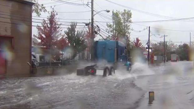
Rain was falling at a rate of 1 inch per hour in parts of New Jersey and more than 3 inches of rain had fallen in Newark. Brian Thompson reports.(Published Monday, Oct. 30, 2017)
In New Jersey, at least 10,000 customers were without power. Severe flooding was causing streets to close. Like Long Island, trees were knocked down as well as powerlines. In Hackensack, the fire department said large tree limbs fell onto a house, causing roof damage. No injuries were reported.
With strong winds a factor overnight, power outages could be affected into Monday, however, if the rain lets up, streets should reopen for the morning commute.
In Fairfield County, Connecticut, about 9,000 people were reported without power.
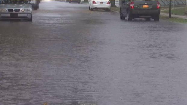
Stormy Weather Leads to Flooded NYC Streets

Streets in Queens are flooded after the stormy weather and all five boroughs remain under a high wind warning. Ida Siegal reports.(Published Monday, Oct. 30, 2017)
An areal flood warning was issued in New York City Sunday night, with as much as 3 inches of rain falling by evening and 1-2 inches expected in the hours thereafter.
The entire tri-state is under a flash flood watch 6 a.m. until Monday. (See the full list of weather watches and warnings below.)
Streets Impassable in NJ as Storm Drops Inches of Rain
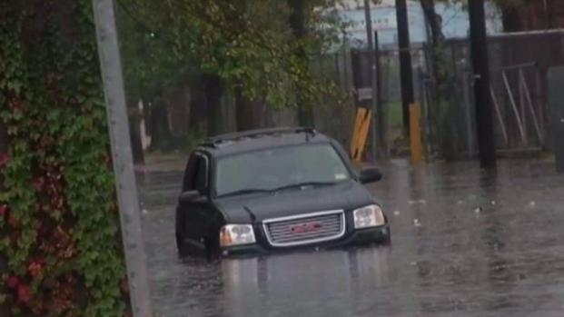
Floodwaters filled the streets of Newark and other New Jersey cities during Sunday's storm. Brian Thompson reports.(Published Sunday, Oct. 29, 2017)
The storm dropped at least 2-3 inches of rain across the region, with some areas seeing more than that, Storm Team 4 says.
By Sunday night, rain was falling at a rate of 1 inch per hour in parts of New Jersey. More than 3 inches of rain had fallen in Newark, and in parts of Suffolk County nearly 3.5 inches had fallen. Isplip alone saw nearly four inches of rain. Central Park saw nearly 3 inches of rain, as did LaGuardia. Bridgeport, Connecticut saw just under 3 inches.
Pounding Wind, Severe Flooding Threaten Long Island

Parts of Long Island were expected to get the brunt of a storm that led to flood and wind advisories across the tri-state. Greg Cergol reports.(Published Sunday, Oct. 29, 2017)
The severe weather threat comes five years to the day Sandy made landfall in New Jersey, beginning its days-long siege on the tri-state area that left dozens dead and caused billions of dollars in damage.
Gov. Andrew Cuomo said he had directed state agencies to take precautionary measures for the storm, and utility company PSE&G mobilized its employees and contractors to respond to any damage the rain and high winds might cause.
High Wind and Rain Slam NYC
A high wind warning and flash flood watch were in effect for all five boroughs Sunday. Ida Siegal reports.(Published Sunday, Oct. 29, 2017)
The strongest winds are likely until noon Monday. Storm Team 4 says the windiest areas are expected to be on Long Island, but that gusts of more than 40 mph are likely in the city and Hudson Valley even after showers have passed early Monday morning.
It will be gusty and cool on Monday as rains taper off into the afternoon. The weather then improves for Halloween, with partly to mostly sunny skies forecast and highs in the upper 50s, Storm Team 4 says.The rest of the work week is cloudy as temperatures hover around the low 60s during the day. A few passing showers are possible Thursday, but it's dry and mild to end the week.