


MAJOR EVENTS LIKE THE ONE WALLOPING SE TEXAS AND THE CALIFORNIA DROUGHT ARE OCCURRING EVERY TEN YEARS OR SO.
Houston's Flood Is a Design Problem
It’s not because the water comes in. It’s because it is forced to leave again.
 Richard Carson / Reuters
 Ian Bogost
August 28, 2017
Floods cause greater property damage and more deaths than tornadoes or hurricanes. And Houston’s flood is truly a disaster of biblical proportions: The sky unloaded 9 trillion gallons of water on the city within two days, and much more might fall before Harvey dissipates, producing as much as 60 inches of rain.
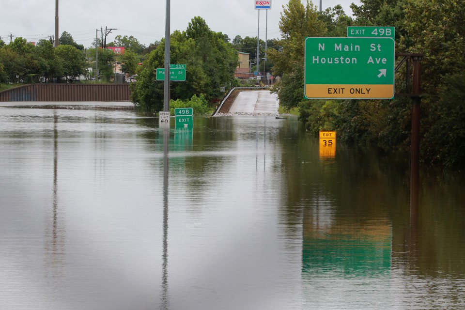
Pictures of Harvey’s runoff are harrowing, with interstates turned to sturdy and mature rivers. From Katrina to Sandy, Rita to Tōhoku, it’s easier to imagine the flooding caused by storm surges wrought by hurricanes and tsunamis. In these cases, the flooding problem appears to be caused by water breaching shores, seawalls, or levees. Those examples reinforce the idea that flooding is a problem of keeping water out—either through fortunate avoidance or engineering foresight.
But the impact of flooding, particularly in densely developed areas like cities, is far more constant than a massive, natural disaster like Harvey exposes. The reason cities flood isn’t because the water comes in, not exactly. It’s because the pavement of civilization forces the water to get back out again.
* * *
There are different kinds of floods. There’s the storm surge from hurricanes, the runoff from snowmelt, the inundation of riverbanks. But all these examples cast flooding as an occasional foe out to damage human civilization. In truth, flooding happens constantly, in small and large quantities, every time precipitation falls to earth. People just don’t tend to notice it until it reaches the proportions of disaster.
Under normal circumstances, rain or snowfall soaks back into the earth after falling. It gets absorbed by grasslands, by parks, by residential lawns, by anywhere the soil is exposed. Two factors can impede that absorption. One is large quantities of rain in a short period of time. The ground becomes inundated, and the water spreads out in accordance with the topography. The second is covering over the ground so it cannot soak up water in the first place. And that’s exactly what cities do—they transform the land into developed civilization.
Roads, parking lots, sidewalks, and other pavements, along with asphalt, concrete, brick, stone, and other building materials, combine to create impervious surfaces that resist the natural absorption of water. In most of the United States, about 75 percent of its land area, less than 1 percent of the land is hardscape. In cities, up to 40 percent is impervious.
The natural system is very good at accepting rainfall. But when water hits pavement, it creates runoff immediately. That water has to go somewhere. So it flows wherever the grade takes it. To account for that runoff, people engineer systems to move the water away from where it is originally deposited, or to house it in situ, or even to reuse it. This process—the policy, planning, engineering, implementation, and maintenance of urban water systems—is called stormwater management.The combination of climate change and aggressive development made an event like this almost inevitable.
According to my Georgia Institute of Technology colleague Bruce Stiftel, who is chair of the school of city and regional planning and an expert in environmental and water policy governance, stormwater management usually entails channeling water away from impervious surfaces and the structures built atop them. In other words, cities are built on the assumption that the water that would have been absorbed back into the land they occupy can be transported away instead.
Like bridges or skyscrapers designed to bear certain loads, stormwater management systems are conceived within the limits of expected behavior—such as rainfall or riverbank overrun events that might happen every 10 or 25 years. When these intervals are exceeded, and the infrastructure can’t handle the rate and volume of water, flooding is the result.
Houston poses both a typical and an unusual situation for stormwater management. The city is enormous, stretching out over 600 square miles. It’s an epitome of the urban sprawl characterized by American exurbanism, where available land made development easy at the edges. Unlike New Orleans, Houston is well above sea level, so flooding risk from storm surge inundation is low. Instead, it’s rainfall that poses the biggest threat.
A series of slow-moving rivers, called bayous, provide natural drainage for the area. To account for the certainty of flooding, Houston has built drainage channels, sewers, outfalls, on- and off-road ditches, and detention ponds to hold or move water away from local areas. When they fill, the roadways provide overrun. The dramatic images from Houston that show wide, interstate freeways transformed into rivers look like the cause of the disaster, but they are also its solution, if not an ideal one. This is also why evacuating Houston, a metropolitan area of 6.5 million people, would have been a terrible idea. This is a city run by cars, and sending its residents to sit in gridlock on the thoroughfares and freeways designed to become rivers during flooding would have doomed them to death by water.
* * *
Accounting for a 100-year, 500-year, or “million-year” flood, as some are calling Harvey’s aftermath, is difficult and costly. Stiftel confirms that it’s almost impossible to design for these “maximal probable flood events,” as planners call them. Instead, the hope is to design communities such that when they flood, they can withstand the ill effects and support effective evacuations to keep people safe. “The Houston event seems like an illustration that we haven’t figured it out,” Stiftel says.
Many planners contend that impervious surface itself is the problem. The more of it there is, the less absorption takes place and the more runoff has to be managed. Reducing development, then, is one of the best ways to manage urban flooding. The problem is, urban development hasn’t slowed in the last half-century. Cities have only become more desirable, spreading outward over the plentiful land available in the United States.
The National Flood Insurance Program, established in 1968, offered one attempt at a compromise. It was meant to protect and indemnify people without creating economic catastrophe. Instead of avoiding the floodplain, insurance allowed people to build within it, within management constraints recommended by FEMA. In theory, flood-hazard mitigation hoped to direct development away from flood-prone areas through the disincentives of risk insurance and regulatory complexity.Sometimes “living with water” means sidestepping the consequences.
Since then, attitudes have changed. For one part, initial avoidance of floodplains created desirable targets for development, especially in the middle of cities. But for another, Stiftel tells me that attitudes about development in floodplains have changed, too. “It’s more about living with water than it is about discouraging development in areas prone to risk.”
Sometimes “living with water” means sidestepping the consequences. Developers working in flood zones might not care what happens after they sell a property. That’s where governmental oversight is supposed to take over. Some are more strict than others. After the global financial crisis of 2008, for example, degraded local economies sometimes spurred relaxed land-use policy in exchange for new tax bases, particularly commercial ones.
In other cases, floodplains have been managed through redevelopment that reduces impervious surfaces. Natural ground cover, permeable or semi-permeable pavers, and vegetation that supports the movement of water offer examples. These efforts dovetail with urban redevelopment efforts that privilege mixed-use and green space, associated with both new urbanism and gentrification. Recreation lands, conservation lands and easements, dry washes, and other approaches attempt to counterbalance pavement when possible. Stiftel cites China’s “sponge cities” as a dramatic example—a government-funded effort to engineer new, permeable materials to anticipate and mitigate the flooding common to that nation.
* * *
But Thomas Debo, an emeritus professor of city planning at Georgia Tech who also wrote a popular textbook on stormwater management, takes issue with pavement reduction as a viable cure for urban flooding. “We focus too much on impervious surface and not enough on the conveyance of water,” he tells me. Even when reduced in quantity, the water still ends up in in pipes and concrete channels, speeding fast toward larger channels. “It’s like taking an aspirin to cure an ailment,” he scoffs. Houston’s flooding demonstrates the impact.
Instead, Debo advocates that urban design mimic rural hydrology as much as possible. Reducing impervious surface and improving water conveyance has a role to play, but the most important step in sparing cities from flooding is to reduce the velocity of water when it is channelized, so that it doesn’t deluge other sites. And then to stop moving water away from buildings and structures entirely, and to start finding new uses for it in place.
That can be done by collecting water into cisterns for processing and reuse—in some cases, Debo explains, the result can even save money by reducing the need to rely on utility-provided water. Adding vegetation, reclaiming stormwater, and building local conveyance systems for delivery of this water offer more promising solutions.
Though retired from Georgia Tech, Debo still consults on the campus’s local stormwater management efforts. In one case, the institute took a soccer field and made it into an infiltration basin. Water permeates the field, where it is channeled into pipes and then into local cisterns.A centralized approach to stormwater management is a pipe dream.
In Houston’s case, catastrophic floods have been anticipated for some time. The combination of climate change, which produces more intense and unpredictable storms, and aggressive development made an event like this week’s almost inevitable. The Association of State Floodplain Managers has called for a national flood risk-management strategy, and the Houston Chronicle has called flood control the city’s “most pressing infrastructure need.” A lack of funding is often blamed, and relaxed FEMA regulations under the Trump Administration won’t help either.
But for Debo and others, waiting for a holistic, centralized approach to stormwater management is a pipe dream anyway. Just as limiting impervious surface is not the solution to urban stormwater management, so government-run, singular infrastructure might not be either. “It’s much more difficult, and a much bigger picture,” Debo insists to me. “There is no silver bullet for stormwater management.”
* * *
One problem is that people care about flooding, because it’s dramatic and catastrophic. They don’t care about stormwater management, which is where the real issue lies. Even if it takes weeks or months, after Harvey subsides, public interest will decay too. Debo notes that traffic policy is an easier urban planning problem for ordinary folk, because it happens every day.
So does stormwater—it just isn’t treated that way. Instead of looking for holistic answers, site-specific ones must be pursued instead. Rather than putting a straight channel through a subdivision, for example, Debo suggests designing one to meander through it, to decrease the velocity of the water as it exits.
The hardest part of managing urban flooding is reconciling it with Americans’ insistence that they can and should be able to live, work, and play anywhere. Waterborne transit was a key driver of urban development, and it’s inevitable that cities have grown where flooding is prevalent. But there are some regions that just shouldn’t become cities. “Parts of Houston in the floodway, parts of New Orleans submerged during Katrina, parts of Florida—these places never should have been developed in the first place,” Debo concludes. Add sea-level rise and climate-change superstorms, and something has to give.
Debo is not optimistic about resisting the urge toward development. “I don’t think any of it’s going to happen,” he concedes. “Until we get people in Congress and in the White House who care about the environment, it’s just going to get worse and worse.”
Even so, there’s reason for optimism. If good stormwater management means good, site-specific design, then ordinary people have a role to play, too. Residential homeowners who install a new cement patio or driveway might not even realize that they are channeling water down-grade to their neighbors, or overwhelming a local storm drain. Citizens can also influence stormwater issues within their municipalities. Many folks know that they have a local city council and school board, but local planning, zoning, and urban design agencies also hold regular public meetings—unfortunately, most people only participate in this aspect of local governance when they have an axe to grind. For the average American concerned with the deluge, the best answer is to replace an occasional, morbid curiosity with flooding with a more sophisticated, long-term interest in stormwater management.
================
Tropical Storm Harvey raises red flags on over-development in poor soil, proper water infrastructure, climate planning
Tropical Storm Harvey, which has shattered longstanding weather records, would've spelled disaster for just about any city it struck. After all, parts of the Houston area have received half their annual rainfall in just a few days' time.
Yet Houston is not an ordinary city when it comes to flood infrastructure. And this flood has lessons for policymakers at all levels of government — including President Donald Trump — about how to protect Americans in an era of rising disaster risks related to population growth, aging infrastructure, and climate change.
To some extent, the scenes of a major American city underwater seems like Mother Nature's riposte to the Trump administration, which has spent 7 months methodically reversing the climate change policies enacted of President Barack Obama. From the planned pullout of the Paris Climate Agreement to an executive order pulling back Obama-era protections mandating that infrastructure plans take sea level rise into account, Trump is setting more American cities up for future Harvey-level disasters.
The Houston flood is likely to go down in history as the worst flood in any U.S. city on record.
That's no surprise to experts who have long warned about Houston's vulnerability to tropical storms and hurricanes. The city is low-lying, rapidly growing, and its government is paying little attention to long-term disaster risk management and resilience.
History is replete with examples of severe Houston floods, including Tropical Storm Allison in 2001, which killed 41 and caused $9 billion in damage, as well as flooding in 2016 that shut down the city for days.
Houston is America's poster child of sprawl — with development policies that give little regard to the need for drainage systems. The city is criss-crossed by a complex network of bayous that are easily overwhelmed by heavy rain, made worse by sudden inflows of water from impervious surfaces like concrete.
“Given that you have a city of 6.5 million people with a floodplain mostly paved over and populated, there’s a risk of this always,” said Adam Sobel, a professor of Earth and environmental sciences at Columbia University.

River gauge showing record flooding on Aug. 28, 2017.
Image: usgs/NOAA
Katharine Hayhoe, a climate scientist at Texas Tech University, said Houston is a "perfect storm" of flood risk due to population growth, crumbling infrastructure, and development based on the "obsolete assumption" that we have a stable climate. Houston's infrastructure flaws and extraordinary vulnerability to hurricanes were detailed in investigative reporting published last year by Pro Publica and the Texas Tribune.
Was this climate change? Sort of


Sobel, Hayhoe and others say that climate change may have played an important, but backseat role in creating the Houston flood disaster, with development decisions serving to more sharply heighten Houston's vulnerability to flash flooding.
“I think it’s clear that this storm or something close to it could’ve happened without any climate change," Sobel said, adding that climate change may have exacerbated the storm's hazards.
As for global warming's possible role in this event, climate scientists say there are aspects of this storm that are suspicious, and may point toward possible links to global warming.
One is the sheer amount of rain, upwards of 40 inches already, with final rainfall totals of 50 inches not out of the question. If this is reached, it would set an all-time Texas record.
Another is the sheer tenacity of the storm, which has remained a named tropical storm longer than any landfalling tropical cyclone in Texas' history, according to hurricane statistics expert Philip Klotzbach of Colorado State University.
The science linking Harvey to global warming is tenuous, however, but may be firmed up over time by peer reviewed studies.
Scientists suspect that the storm has lasted longer over land and dumped more rain than it otherwise would have, thanks to the ability of a warmer atmosphere to contain more moisture.
Studies published in the past few years have shown that extreme precipitation events are becoming more common and more extreme in many parts of the world as the air and oceans continues to warm, and that this trend is expected to continue.
With tropical storms and hurricanes, computer model simulations show that future storms are likely to be wetter, posing even greater inland flood challenges than we're used to now.
There are elements of Harvey that stand out, including the 16.07 inches of rain that fell in Houston on August 27, setting a record for the wettest day in that city's history. The storm has dropped so much rain in southeast Texas that the National Weather Service had to add a new color to its maps.
Scientists are likely to conduct extreme event attribution studies on the heavy rainfall from Hurricane Harvey, Sobel said, and these are likely, though not guaranteed, to show a climate change-related increase in the odds for such extreme rainfall amounts.
“If I had to guess what those studies to show they’ll indicate that rainfall was magnified somewhat by the warmer atmosphere so that whatever the cost of this event… it will be a little higher than it would’ve otherwise been,” Sobel said.
Hayhoe agrees, saying, “Will there be more rain associated with a given hurricane? That is not a hard question to answer: The answer is yes.”
The rainfall totals have reached a historic magnitude in large part because the storm has sat nearly stationary since Saturday, pulling in moisture off the Gulf of Mexico and dumping it on southeast Texas.
Tropical Storm Harvey has been caught between two high pressure areas, a strong one to the west and another to the east. These have left it up to its own devices, as upper level steering currents collapsed.
This lack of movement is unlikely to be related to global warming, Sobel and others said, but some research has shown a possible link between blocking high pressure areas, stuck weather patterns, and global warming.
“Every event has many causes and the predominant one is always natural. But climate change can amplify the odds,” Sobel said.
Kevin Trenberth, a climate scientist at the National Center for Atmospheric Research (NCAR) in Boulder, Colorado, said the historic rains can be thought of as the result of a combination of a climate change-related increase in water vapor plus a big contribution from natural weather patterns, which can greatly amplify the water vapor present in a given storm.

Chart showing the level of scientific confidence in attributing types of extreme weather events to climate change.
Image: national academy of sciences
"The outstanding thing about recent storms has been the prodigious rainfalls: over Louisiana one year ago, and the with [Hurricane] Matthew in October last year," he said in an email.
"In both cases record amounts of total column water vapor (called precipitable water) were recorded with radiosondes. No wonder the flooding occurred," Trenberth said, referring to measurements from weather balloons.
Hayhoe said reducing flood risk in cities like Houston will require sustained investments in improved infrastructure. Such actions would need to take into account the fact that our climate is changing, and that what was once a 500-year-flood is now closer to a 1-in-50 year event.
“If we build based only on what we’ve seen in the past, we won’t be able to cope with the naturally-occurring weather and extreme events that we get today, many of which are being exacerbated by the changing climate,” she said.
“Unfortunately, long-term planning and investment is not really a hot topic or a soundbite these days for many politicians,” she said. “It’s a very difficult thing t
o do.”
===========
WE WARNED YOU, BUT YOU DID NOT LISTEN: HOUSTON, TEXAS IS PAYING A HEAVY PRICE FOR THE RECKLESS OVER-DEVELOPMENT WITHOUT PROPER INFRASTRUCTURE TO HANDLE MAJOR FLOODING EVENTS
Houston Wasn’t Built for a Storm Like This
It won’t be next time either.
By Henry Grabar
 A submerged car is seen on Interstate 610 North on Sunday in Houston as the city battles with tropical storm Harvey and resulting floods.
 Thomas B. Shea/AFP/Getty Images
Houston is in the midst of what appears to be the worst flooding to strike a major U.S. city since the levees broke in New Orleans after Hurricane Katrina in 2005.
Henry Grabar
Hurricane Harvey has been downgraded to a tropical storm, but it was never the water from the ocean that Houston had to fear but the water from the sky. And the rain just keeps on coming, even as flooding has rendered major freeways impassable. Buffalo Bayou, the meandering river that passes through the center of the city, is expected to crest 14 feet above its previous record. Overhead video shows vast areas of the city’s single-family home neighborhoods swamped by brown water. Downtown is an island. More rain is projected through Tuesday.
America’s fourth-largest city is still full of people: Citizen flotillas of kayaks and outboards are rescuing Houstonians from cars, trucks, rooftops, and second-floor windows, complementing a severely overwhelmed official relief effort. On Sunday afternoon, emergency service lines were so inundated that callers could only get busy signals, the Houston Chronicle’s Lydia DePillis reported. At one point the wait for 911 was two-and-a-half hours, a Houstonian told Laura Nelson of the Los Angeles Times. Texans are using Twitter to ask people to save their lives. And many of us are wondering who is to blame.
The immediate question is why local officials did not encourage people to evacuate. On Friday, as the Hurricane neared landfall, Gov. Greg Abbott issued a somewhat half-hearted warning to residents along the coast: “Even if an evacuation order hasn’t been issued by your local official, if you’re in an area between Corpus Christi and Houston, you need to strongly consider evacuating.”
But that suggestion was contradicted by local officials in Houston and its many suburban cities, who said, basically: This isn’t the Jersey Shore or the Outer Banks or even New Orleans. “You can’t put—in the city of Houston—2.4 million people on the road,” Houston Mayor Sylvester Turner said at a press conference on Sunday, defending the decision. Together with surrounding Harris County, 6.5 million people would have had to leave—including tens of thousands of people without transportation and more than 550,000 undocumented immigrants who fear the federal and state governments. Many Houstonians remember 2005, when an attempted evacuation for Hurricane Rita created the worst traffic jam in the city’s history and killed as many people as the hurricane itself—through heat stroke, and a bus that caught fire. The freeways where motorists sat stranded during Rita are underwater now. During last year’s floods, most deaths also occurred in cars.
One underlying cause of Houston’s suffering is that developers and town officials in Harris County, which contains Houston, have for years advocated the development of the wetlands and prairies around the city—land that had long served to absorb the rainwater that now overwhelms the region’s sewers and streams every year. The flood-absorbent grasslands of the Katy Prairie have been cut by three-quarters over the past few decades as Houston sprawled west. The state played along, funding expansion of I-10, “the Katy Freeway,” and another road, the Grand Parkway, which further opened that land up for development. To make matters worse, money-hungry officials also encouraged development in low-lying, flood-prone areas without regard to future risk. There have been more than 7,000 units built in the hundred-year floodplain since 2010, according to a ProPublica/Texas Tribune analysis. Efforts to reform the city's building codes have been met with strong resistance in an area where homebuilding has been a major economic engine.
Last year, the longtime head of the Harris County flood control district, Mike Talbott, told ProPublica that his agency had no plans to study the impact of climate change on the region’s flooding problems. Here’s a quote from that article, which is well worth reading in full:
Of the astonishing frequency of huge floods the city has been getting, he said, “I don't think it's the new normal.” He also criticized scientists and conservationists for being “anti-development.”
“They have an agenda ... their agenda to protect the environment overrides common sense,” he said.
Still, the debates over evacuation and development are spurious confronted with a storm this size, and the trend it represents: a strength and frequency of weather events that challenge all previous notions of risk assessment. This is the third straight year that Houston has endured a devastating, once-in-a-lifetime flood. There were the Memorial Day floods in 2015 and the Tax Day floods in 2016. Together the storms killed 16 people and caused more than $1 billion in damage. More than a third of the properties that flooded in Houston’s 2015 Memorial Day floods were located outside the “hundred-year floodplain,” the zone in which FEMA requires homeowners with government-backed mortgages to elevate homes or buy flood insurance. Now with Harvey, Houston has been hit with six “hundred-year storms” since 1989.
Early Sunday, the National Weather Service essentially threw up its hands:
Even the president seemed to have a sense that something extraordinary was afoot. “We have an all out effort going, and going well!” the president tweeted from Camp David on Sunday morning. “Even experts say they’ve never seen one like this,” he added later.
Here’s how the Washington Post’s Capital Weather Gang described it:
The total rainfall from the storm is likely to tally up to a widespread 15 to 30 inches, with a few localized spots picking up 50 inches or more. Many textbooks have the 60-inch mark as a once-in-a-million-year recurrence interval, meaning that if any spots had that amount of rainfall, they would essentially be dealing with a once-in-a-million-year event.
Cities are built around levels of expected risk, ascertained by residents and businesses and enforced by finance and insurance and government. Will a bank loan you the money to build that house, or to buy it? Will an insurer back those loans? Will a city official permit it? It now seems clear that in the case of Houston, those estimates—forged on years of historical data—have been decimated by the planet’s changing atmosphere.
It does not make sense to say climate change “caused” a hurricane. But, as the climate scientist Michael Mann wrote, "it exacerbates several characteristics of the storm in a way that greatly increased the risk of damage and loss of life.” And at the Atlantic, Rob Meyer has a thoughtful evaluation of the ways in which climate change has enabled larger, more dangerous, faster-growing storms. The oil capital of the world drowned by an atmosphere teeming with greenhouse gases.
The science isn’t certain, of course. But the extremity of the storm is. No land-use regime can proof a city for 50 inches of rain. Perhaps it is possible to move 6.5 million people out in 48 hours, but we have yet to accomplish it. The problem Houston has is more severe. Until the modern era, it was routine for disasters—mostly fire, flood, and pestilence—to serve as checks on the growth of urban centers. We have almost forgotten that used to happen, but it’s not unheard of: The population of New Orleans fell by half after Katrina, and remains about 15 percent smaller than it was in 2005. (About 100,000 of those people settled in Houston.) After three straight years of catastrophic floods, America’s fastest-growing city may be reaching a turning point.
Top Comment
A few of observations commenting from Houston right now a few hours later: 1) I don't mean to trivialize it when people lose their homes, but right now 97% of Houston has power and a higher percentage have completely dry... More...