


WINTHROP, Minn. - Sibley County is cleaning up after being hit with hail, some of it as big as baseballs, in Sunday night's storms.
Emergency managers say there were no injuries and no homes lost, but the wind and hail still left quite a mess, including at the Winthrop Golf Club.
"It looked like a disaster area," said club President Gary Schneider. "Yeah, it was not pretty."
Schneider says the fallen trees and limbs are nothing compared to the divots.
"See all these marks here?" he said. "That's all hail. ... We have real nice greens here and now you can take a look at this, it's damaged pretty well."

Sunday night's hail in Winthrop left divots in the course at Winthrop Golf Club. (Photo: Chad Nelson, KARE 11)
And that damage goes far beyond the golf course.
The hail punched holes in homes in Sibley and Nicollet Counties, including Beth and Kevin Fluegge's.
"It sounded like somebody was sending baseballs at the house," Beth Fluegge said.
And hail was just the beginning.
"The posts that anchor the whole building, every one of them is pulled out of the ground," Kevin Fluegge said.
The National Weather Service told them a tornado likely carved this path.
"500 feet," he said. "At least. And I don't know what's all out there."
But somehow the trail of destruction bypassed their home.

Beth and Kevin Fluegge's property experienced massive storm damage Sunday night, but their house was safe. (Photo: Chad Nelson, KARE 11)
"Shed is a loss, the garden is a loss, the crops are lost, but people are still here, so that's the good thing," Beth Fluegge said.
Helping hands are a good thing too – and a lot of volunteers are helping both on the farm and at the Winthrop Golf Club.
And they say they'll keep it up until all the holes are repaired.
Though there is still considerable cleanup yet to take place at the golf course, organizers are hopeful that they'll get open relatively soon. They're aiming right now for Tuesday night, which is league night.
================
Summary of July 9, 2017 Minnesota Severe Weather Event
Numerous severe thunderstorms impacted much of central and southern Minnesota during the evening of Sunday, July 9, 2017. There were many reports of very large hail, in excess of 2" in diameter, with one report of a 4" hail stone. In addition, reports from spotters and law enforcement indicated that at least one tornado may have touched down in southern Nicollet and/or northwest Blue Earth Counties. A damage survey team from the National Weather Service reviewed the area of damage and confirmed that two tornadoes occurred: an EF-0 near Courtland in Nicollet County and an EF-1 near Lake Crystal in Blue Earth County.
Tornadoes:
|
Tornado #1 - Near Courtland
Nicollet County
|
||||||||||||||||
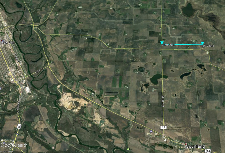 Tornado #1 Track Map Tornado #2 - North of Lake Crystal Blue Earth County
|
||||||||||||||||
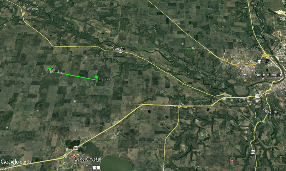
Tornado #2 Track Map
The Enhanced Fujita (EF) Scale classifies tornadoes into the following categories:
| EF0 Weak 65-85 mph |
EF1
Moderate 86-110 mph |
EF2
Significant 111-135 mph |
EF3
Severe 136-165 mph |
EF4
Extreme 166-200 mph |
EF5
Catastrophic 200+ mph |
 |
|||||