MEC&F Expert Engineers

Saturday, September 3, 2016

The probable cause of the Cessna 182C single-engine airplane, N8777T, crash near Pattonsburg, Missouri was the pilot's loss of airplane control while maneuvering during low-level flight

The National Transportation Safety Board determines the probable cause(s) of this accident as follows:  The pilot's loss of airplane control while maneuvering during low-level flight for reasons that could not be determined because examination of the airframe and engine did not reveal any preimpact anomalies.
 
NTSB Identification: CEN16FA059
HISTORY OF FLIGHT

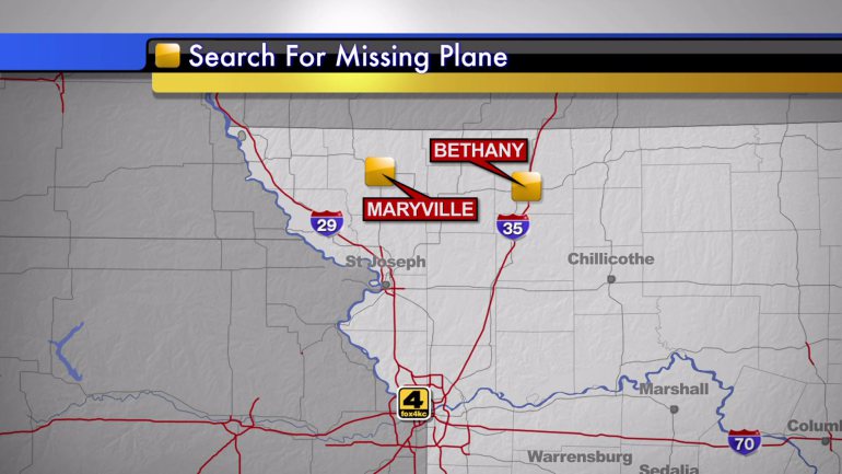
On December 6, 2015, about 1630 central standard time, a Cessna 182C single-engine airplane, N8777T, impacted terrain near Pattonsburg, Missouri. The private pilot, who was the sole occupant, sustained fatal injuries, and the airplane was destroyed. The airplane was registered to and operated by a private individual as a 14 Code of Federal Regulations Part 91 personal flight. Visual meteorological conditions prevailed and a flight plan was not filed. The airplane departed the Northwest Missouri Regional Airport (EVU), Maryville, Missouri, about 1550, and was destined for the Bethany Memorial Airport (75K), Bethany, Missouri.

According to local authorities, family members and witnesses, the pilot was planning a flight from EVU to 75K after picking up his airplane from a maintenance facility that completed annual inspection on the airplane. There were no recorded communications between the pilot and air traffic control services.

A review of radar data showed a radar target consistent with the accident airplane was first observed by the Oskaloosa Air Route Surveillance Radar sensor, Oskaloosa, Kansas, at 1603:06, about 20 miles east of EVU. Radar data showed the airplane traveled toward the southeast and the final radar data point was about 11 miles west of the accident location at 1611:55. No mode C altitudes associated with the accident airplane were reported.

Several witnesses near the accident site reported hearing or observing the airplane flying in a low altitude and maneuvering to the north, east, and south directions. Witnesses described the airplane as flying about tree top level. Some witnesses reported they heard an airplane, a possible crashing noise, and then no airplane or engine sound.

About 1922, the Federal Aviation Administration (FAA) issued an Alert Notice (ALNOT) for the airplane due to concerned family members. The airplane was located about 0900 on December 8th by local search and rescue personnel.

Family members and friends stated the pilot would routinely fly near the Pattonsburg area to view a nearby lake and the river system. In addition, the pilot would on occasion overfly a friend's residence. From the Pattonsburg area, the pilot would fly along highway 69 to the north toward Bethany airport as a regular flight path.

PERSONNEL INFORMATION

The 54 year-old pilot held a private pilot certificate with an airplane single-engine land rating. The pilot was issued a third class medical certification on September 9, 2015, with no limitations. According to the pilot's most recent airman medical application, he had accumulated 304 total flight hours and 3 hours in the last 6 months. The pilot's logbook was not located during the investigation.

According to family representatives, the pilot was in excellent health and had no known medical conditions.

AIRCRAFT INFORMATION

The accident airplane was a 1960 Cessna 182C, serial number 52677. The airplane was powered by a Continental O-470-L reciprocating engine and a two-bladed McCauley controllable pitch propeller. The airplane was issued a standard airworthiness certificate on March 31, 1960. The airplane was registered to the owners on November 13, 2012.

According the airplane's logbooks, the most recent annual inspection was completed on November 27, 2015, at a total airframe and tachometer time of 4,547.3 hours. At the time of the annual inspection, the engine had accumulated 1,172.3 hours since major overhaul. Since an annual inspection on June 2, 2012, to the most recent annual inspection, the airplane had accumulated 116.3 hours, per the tachometer.

METEOROLOGICAL INFORMATION

The pilot did not receive an official weather briefing from Lockheed Martin Flight Service or any other official source.

At 1555, the Schenck Field Airport (ICL), Clarinda, Iowa, automated weather observing system (AWOS), located approximately 22 miles north of EVU, reported the wind from 050 degrees at 3 knots, 10 miles visibility, sky clear, temperature 5 degrees Celsius, dew point 3 degrees Celsius, and an altimeter setting of 30.31 inches of mercury.

At 1629, the Lamoni Municipal Airport (LWD), Lamoni, Iowa, automated surface observing system (ASOS), located approximately 35 miles north of the accident site and 22 miles north of 75K, reported the wind from 310 degrees at 11 knots, 3 miles visibility, mist, sky overcast at 300 feet, temperature 3 degrees Celsius, dew point 3 degrees Celsius, and an altimeter setting of 30.28 inches of mercury.

At 1637, the LWD ASOS reported the wind from 300 degrees at 10 knots, 2 1/2 miles visibility, mist, sky overcast at 300 feet, temperature 3 degrees Celsius, dew point 3 degrees Celsius, and an altimeter setting of 30.28 inches of mercury.

A review of the Geostationary Operational Environmental Satellite (GOES) system data for 1615 showed a low-topped stratus cloud deck that extended over the accident site. The cloud tops were estimated to be about 7,500 mean sea level (msl); however, it is unknown if the deck layered to the surface.

An Airmen's Meteorological Information (AIRMET) was issued and valid for instrument flight rules (IFR) conditions near the accident site location.

About 0800, the Minneapolis Air Route Traffic Control Center Central Weather Service Unit issued an advisory for IFR and occasional low IFR conditions over Iowa with conditions expected to spread southward.

A family member, who dropped off the pilot at EVU and returned to the Bethany area, reported the weather conditions were good about the time the pilot was scheduled to land at 75K.

WRECKAGE AND IMPACT INFORMATION

Examination of the accident site revealed the airplane impacted in wooded terrain along a measured magnetic heading of 360 degrees at an elevation of 877 feet msl. Airplane damage and tree strike signatures were consistent with a nose low, near vertical impact. All major components of the airplane were located at the accident site.

The left wing, right wing, fuselage, and empennage were crushed forward and fragmented. All flight control surfaces remained attached to their respective attach points. Control cable continuity was established and confirmed. Flap position was not determined due to impact damage. The elevator trim actuator extension was measured and correlated to a slight nose down trim condition. The fuel selector was found in the right tank position. Both fuel tanks were ruptured and no residual fuel was noted at the accident site. Both fuel caps were found secured.

The forward fuselage and cockpit were fragmented and bent. The pilot's seat belt was found secured, and the seatbelt ends were cut by rescue personnel. The instrument panel was destroyed. The cockpit engine throttle and propeller positions were not determined, and the mixture control was full forward. The emergency locator transmitter (ELT) was destroyed.

The engine remained partially attached to the fuselage and came to rest in the initial impact crater. The engine crankcase displayed impact damage, and a large section of the crankcase had separated exposing the internal components of the engine. The crankshaft was fractured between the number 5 and 6 connecting rod journals, and displayed fracture features consistent with an overload failure. The engine cylinders remained partially attached to the crankcase and displayed impact damage.

The carburetor remained attached to the mounting pad, and the mounting pad was separated from the induction system. The throttle valve was found in the full open/throttle position. Both magnetos were separated from their respective mounts. The vacuum pump displayed impact damage and was disassembled. The vacuum pump displayed normal operating and lubrication signatures, and the vanes remained intact.

The propeller was separated from the crankshaft and the hub was destroyed. One propeller blade displayed leading edge gouging, chordwise scratches, and polishing. One propeller blade displayed a leading edge gouge and chordwise scratches. One propeller blade tip fractured in two sections, and displayed curling deformation. One curled section contained debris consistent with tree or wood material.

MEDICAL AND PATHOLOGICAL INFORMATION

An autopsy of the pilot was performed by the Frontier Forensics Midwest Morgue of Kansas City, Kansas, on December 9, 2015. The pilot's death was attributed to blunt force injuries sustained as a result of the accident.

The Bioaeronautical Research Laboratory at the FAA's Civil Aerospace Medical Institute completed a Final Forensic Toxicology Fatal Accident Report which was negative for ethanol and tested drugs.

TESTS AND RESEARCH

Due to the damage to the airplane's instruments, avionics equipment, and engine components, no functional testing of the equipment was able to be conducted.


========


A Daviess County Sheriff's Department deputy confirmed Tuesday that the pilot of a small plane that crashed in Northwest Missouri was dead.

The plane was believed to be piloted by Ridgeway, Missouri resident Kenny Stoner, 54. Stoner took off Sunday from Northwest Missouri Regional Airport in Maryville at about 4 p.m. and had filed a flight plan to fly to nearby Bethany in Harrison County. He never arrived.

Authorities located and secured the wreckage scene Tuesday morning. The plane was found north of Pattonsburg at about 9:30 a.m. Officials described the crash site area as rugged and hard to reach. They said the wreckage was all in the same location, indicating that the plane had not broken up during flight.

"It was found in the northern part of the county," said Jim Boothe, emergency management director of Gentry County. "Crews are on the scene."

Investigators from the National Transportation Safety Board arrived at the crash site at about 1 p.m. Later, Federal Aviation Administration officials arrived and took control of the investigation.

The search for the missing Cessna 180 resumed Tuesday at around 8 a.m. Law enforcement and emergency management officials from throughout the area participated in the search.

Authorities map out a region to search in the rescue attempt of a missing Ridgeway, Missouri pilot at a staging area in Pattonsburg, Missouri Monday. The missing pilot failed to land in Bethany Sunday and prompted an expansive search throughout Northwest Missouri. 


GENTRY COUNTY, Mo.

Authorities have found the wreckage of a small plane that was reported missing Sunday.

There is no word on the pilot, Kenny Stoner.

"We have found the plane wreckage. It is in Daviess County, north of Pattonsburg in a very rugged and rural area," said Gentry County Emergency Management Director Jim Boothe. "We do not have much more information other than we confirmed it is the plane. We currently have crews going to the site right now to continue the rescue hopefully."

Authorities discovered the wreckage near Cord Avenue and 151st Street just outside Pattonsburg around 9:30 a.m.

Crews have been searching for the Cessna 180 since it disappeared Sunday afternoon after taking off from the Maryville Regional Airport.

Family members notified authorities the plane was missing when it never made it to Bethany, about 60 miles away.

The Federal Aviation Administration is headed to the crash site.

http://www.stjoechannel.com


A vast search for a missing pilot and his plane expanded throughout parts of rural Northwest Missouri Monday.

A search for missing pilot Kenny Stoner, of Ridgeway, Missouri, began Sunday evening after his his plane took off from the Northwest Missouri Regional Airport outside of Maryville, Missouri around 4 p.m. Traveling in a Cessna 180, Stoner never made his scheduled arrival at the Bethany, Missouri airport early Sunday evening.

"All we know is that he was headed to Bethany, Missouri, but when he left he was low on fuel," said Nodaway County Sheriff Darren White. "He was scheduled to land in Bethany, but he did not land as scheduled."

Northwest Missouri airport officials said they did not believe fuel was an issue as Stoner did check the fuel gauges before departure. Officials said there was an issue with the credit card machine, but Stoner did not mention a need to refuel.

With no word from the pilot or no sightings by regional residents, search efforts were expanded Monday afternoon. Law enforcement from Daviess, Nodaway and Gentry counties conducted a rescue mission to find the pilot and the plane.

"Until we find some information to lead differently, this is still a rescue at this point," said Capt. Jacob Denum with the NTA EMS in Bethany and leader of the rescue team, as he manned a mobile staging area in Pattonsburg, Missouri Monday afternoon.

Denum said authorities collected information based off a cell phone ping late Sunday and began the search in the Pattonsburg area. As morning and heavy fog encompassed the region Monday, authorities waited to start the continued search into late morning.

"We have never had to do a search of this magnitude in our area before," Denum said. "We've done several smaller area searches, covering a part of a county before, but nothing that has gone over to multiple counties like this one before."

Troopers with the Missouri State Highway Patrol and civilian pilots also took to the air in hopes of spotting the plane. As the evening progressed, the search was called off by several emergency responders until first light Tuesday morning.

Authorities planned to set up a command post early Tuesday morning in Albany, Missouri and continue the search.

"We will continue to search until we find him and we will continue to search until the airplane is found," Denum said.

Source: http://www.newspressnow.com


GENTRY COUNTY, Mo.
The search continues for a Ridgeway man aboard a small plane that disappeared Sunday afternoon after taking off from the Maryville Regional Airport.

Between 50 and 100 volunteers from multiple fire departments and several aircraft have been seaching since last night to find the Cessna 180 plane.

"We are currently concentrating in the southern part of Gentry County and we're moving north along a possible path that the aircraft may have been traveling," said Gentry County Emergency Management Director Jim Boothe.

Nodaway County Sheriff Darren White said the plane was low on fuel when it took off from the airport.

Family members notified authorities the plane was missing when the man never made it to Bethany, about 60 miles away.

Fog made it difficult for crews to search through the night. A command center was set up early Monday morning in Darlington.

Authorities said they don't know yet if the fog played a role in the plane's disappearance.

"He may have been disorientated in the fog. We're searching a fairly large area in the county. It's rough area and it is slow going and it's muddy right now and that's slowed the effort a little bit," said Boothe. "Until we find something, we're going to stay on the job."

The man's name has not been released.

Source:   http://www.stjoechannel.com


Authorities in Nodaway County are searching for a plane that went missing after taking off from Maryville, Missouri Sunday afternoon.
Nodaway County Sheriff Darren White said the plane, a Cessna 180, attempted to re-fuel at the Northwest Missouri Regional Airport in Maryville. 
Due to a reported difficulty at the regional airport, the pilot was unable to re-fuel.
"All we know is that he was headed to Bethany, Missouri, but when he left he was low on fuel," White said. "He was scheduled to land in Bethany, but he did not land as scheduled."
However, airport officials said they didn't think lack of fuel was a factor if the plane did go down.
White said the pilot, the sole occupant of the plane, is a Ridgeway, Missouri resident. 
Authorities began the search for the plane Sunday night, but the plane and pilot remained missing Monday morning.
"We searched all night," White said.
Because of thick fog, search operations were placed at a "standstill" early Monday. 
Planes were able to take off to resume the search prior to noon as authorities established a command post in nearby Gentry County.
Source: http://www.maryvilledailyforum.com
MARYVILLE, Mo. — Officials are searching for a missing plane in Maryville, Mo.
Darren White with the Nodaway County, Mo Sheriff Department told FOX 4 that the plane took off Sunday night and was headed for Bethany, Mo. 
Sheriff White says he got called at about 8 p.m. on Sunday that reported the pilot never checked in.

Authorities began searching for the plane, but due to the darkness and heavy fog, they discontinued the search around midnight.

Sheriff White says they have been searching for the plane in a large area between Bethany and Maryville.

The pilot was the only person on board the Cessna 180.

The sheriff told FOX 4 that he didn’t know the pilot’s name, but that the pilot lives in Ridgeway, Mo.

The search is expected to resume as soon as the fog lifts.

NTSB: DOUG DEMAREST COMMITTED SUICIDE BY PLANE WHEN HE INTENTIONALLY CRASHED A CIVIL AIR PATROL PLANE INTO AN ALASKA BUILDING; presence of the drug Zolpidem in his liver and kidney were detected

NTSB Identification: ANC16LA011
On December 29, 2015, about 0618 Alaska standard time, a Cessna 172 airplane, N914CP, was destroyed after impacting the side of an office building in Anchorage, Alaska. The private pilot sustained fatal injuries. The airplane was registered to the Civil Air Patrol (CAP), Maxwell Air Force Base, Montgomery, Alabama, and operated by the pilot under the provisions of Title 14 Code of Federal Regulations (CFR) Part 91. Dark night, visual meteorological conditions prevailed at the time of the accident, and no flight plan had been filed. The flight originated from Merrill Field, Anchorage, about 0600.

Witnesses reported seeing the airplane flying in an easterly direction and very low over the city of Anchorage, just before striking the northwest corner of the office building. The airplane's right wing struck the building between the fourth and fifth floors, which severed the entire wing at the fuselage attachment points. The airplane's wreckage continued traveling east while descending into an adjacent office building. It subsequently struck an electrical transformer, and a postcrash fire incinerated the airplane wreckage.

The FAA Civil Aeromedical Institute performed toxicology examinations for the pilot on February 9, 2016, which detected the presence of the drug Zolpidem in the liver and kidney. According to the US National Library of Medicine, Zolpidem is a prescription medication used to treat insomnia and belongs to a class of medications called sedative-hypnotics that work by slowing activity in the brain to allow sleep.

A postmortem examination conducted by the Alaska State Medical Examiner's Office on December 30, 2015, determined the cause of death to multiple blunt force injuries.

The closest weather reporting facility is Merrill Field Airport, Anchorage, about 2 miles east of the accident site. At 0553, an aviation routine weather report (METAR) from the Merrill Field Airport was reporting in part: Wind from 170 degrees at 8 knots, gusting to 18 knots; sky condition few clouds at 7,000 feet; visibility 10 statute miles; temperature 48 degrees F, dew point 26 degrees F; altimeter 29.57 inHg.

According to CAP management personnel the flight had not been authorized. The Anchorage office of the Federal Bureau of Investigation (FBI) has assumed jurisdiction and control of the investigation.


==============

Cessna 172S Skyhawk, N914CP, Civil Air Patrol: Fatal accident occurred December 29, 2015 in Anchorage, Alaska

NTSB Identification: ANC16LA011
14 CFR Part 91: General Aviation
Accident occurred Tuesday, December 29, 2015 in Anchorage, AK
Probable Cause Approval Date: 06/29/2016
Aircraft: CESSNA 172, registration: N914CP
Injuries: 1 Fatal.

NTSB investigators may have traveled in support of this investigation and used data provided by various sources to prepare this aircraft accident report.

Witnesses reported seeing the airplane flying in an easterly direction at a very low altitude before striking the northwest corner of an office building. The airplane's wreckage continued traveling east while descending into an adjacent office building and subsequently struck an electrical transformer. A postcrash fire consumed the airplane wreckage. The private pilot intentionally flew the airplane into the side of the building, and he was killed. The flight was not authorized and the event was an intentional act, so the Federal Bureau of Investigation assumed jurisdiction and control of the investigation.

The National Transportation Safety Board determines the probable cause(s) of this accident as follows:
The pilot's intentional flight into a building.


CIVIL AIR PATROL INC: http://registry.faa.gov/N914CP


Hours before an Anchorage man was killed while piloting an unauthorized flight, police and medics responded to an emergency call at the pilot's home.

Doug Demarest, 42, died when a Civil Air Patrol plane that he did not have permission to fly struck downtown buildings early Tuesday morning. The FBI has joined the National Transportation Safety Board in investigating the crash.

Recordings of police dispatch traffic indicate a woman had called for an emergency response because her husband was incapacitated and not responding appropriately to questions.

The woman was concerned because her husband would not provide a direct answer as to whether he had attempted "11-28," authorities could be heard saying. 11-28 is a police code for suicide.

Police have declined to talk about the visit, other than saying a person was medically evaluated at the home.

Anchorage police spokeswoman Jennifer Castro would not say Thursday whether the people involved in the emergency call were the Demarests. She has confirmed that police and medics responded to a call from a home listed as theirs at 10:03 p.m. Monday. Police and medics stayed until 10:38 p.m.

“There was a patient who needed medical assistance,” Castro said.

Medics evaluated and cleared the patient, she said, with no one was transported to the hospital. The plane Demarest was piloting crashed less than eight hours later.

Story and photo gallery:  http://www.ktuu.com


Doug Demarest


ANCHORAGE -  The FBI is reviewing webcam photos in its investigation of Tuesday's Downtown Anchorage plane crash that killed pilot Doug Demarest and damaged the Brady and Carr-Gottstein buildings.

The series of images are from a webcam operated by borealisbroadband.net. The camera takes a photo every 60 seconds from atop the Denali Towers, looking northwest. Denali Towers is located a 2550 Denali St. between Northern Lights Boulevard and Fireweed Lane.

The footage is from Tuesday morning between roughly 6 a.m. and 6:18 a.m.

Horst Poepperl, the general manager of the webcam service, said the FBI called him on Thursday requesting the footage.

The National Transportation Safety Board declined to comment on the images.

In the video, a bright dot can be seen moving from right to left. Poepperl said it is some sort of aircraft that could going back and forth near downtown Anchorage.

Looking at the time stamp, between 06:16:07 and 06:17:07, Poepperl says you can see in the middle left of the picture the lights on some of the buildings appear to go out. He says this could be when the power went out on the block after the plane crashed.

The Alaska region chief for NTSB, which investigating along with the FBI, has said the impact was reported to 911 at 6:18 a.m.

Story and video:  http://www.ktuu.com


ANCHORAGE – Last Updated: Tues., Dec. 29 at 3:12 p.m.

The pilot who crashed a plane into two office buildings in downtown Anchorage Monday was not authorized to the fly the plane he was piloting, according to a press release from the Civil Air Patrol.

The pilot, identified in the release as 1st Lt. Doug Demarest, was killed when the CAP-owned Cessna 172S he was flying crashed just before 6:30 a.m. An official with CAP confirmed the plane’s tail number – N914CP — in an email Monday.

Demarest joined the Civil Air Patrol in 2010, the release states. The organization says it is “assisting local authorities and the National Transportation Safety Board with the investigation.”

Officials, speaking on background, confirmed the plane took off from Anchorage’s Merrill Field sometime Tuesday morning.

According to public record, Demarest was married to Katherine Demarest, a lawyer with Dorsey and Whitney, LLC. The law firm has an office inside the downtown Anchorage building hit by the plane Monday morning.

Demarest was part of the team of lawyers that recently worked alongside the Alaska Innocence Project and the Alaska Office of Public Advocacy to free the Fairbanks Four.

The “about” section of the website dougdemarest.com, which is still available here, says Doug Demarest was a “former National Park Service Ranger, Outward Bound instructor and NOLS instructor.”

The single-engine Cessna 172S clipped an office building at 1031 W. 4th Ave. before crashing into a building at 310 K St.

Flames caused by the crash damaged an electrical transformer in the area, knocking out power to about 600 customers, according to Municipal Light & Power.

Power has since been restored to almost all of the affected customers.

Update: Tues., Dec. 29 at 11:11 a.m.

The Federal Bureau of Investigation has stepped in to assist local law enforcement with the investigation into Monday morning’s plane crash in downtown Anchorage.

Officials with the FBI said there is no reason to believe the crash was terrorist related.

Additionally, crews have reopened 4th Ave. to traffic, but 3rd Ave. remains closed between K St. and L St. as the investigation continues.

While officials continue to investigate the crash, one local pilot says he feels lucky a similar incident with his own plane ended differently.

Bruce Webb works in a building next to the crash site and has been a pilot for 40 years. He had to make an emergency landing in downtown Anchorage on Seventh Avenue in 2000.

“It was pretty unnerving.  It was 2:30 in the afternoon. School buses, kids, traffic. You look for the clearest spot and head toward that,” Webb recalled. “I walked away but the plane was totaled.”

Webb said it’s hard to look at the wreckage knowing the pilot wasn’t as fortunate as he was.

“It’s tough. Anchorage is the largest small aircraft airport in the world. There are a lot of us pilots out here. It’s tragic when one of us don’t walk away.”

The National Transportation Safety Board is at the scene. The start of the investigation was delayed until fire crews were able to put out the post-crash fire, but heavy winds in the area hindered progress.

The plane was part of the Civil Air Patrol (either a Cessna 172 or Cessna 182) and contained one person, the pilot, according to NTSB spokesman Clint Johnson.

“[Anchorage police] made contact with Civil Air Patrol management … there were no sanctioned flights for this time of the day at this point,” said Johnson. “What we’re trying to do is to put those parts of the pieces together to see how it happened or how the airplane ended up where it is.”

Johnson said it’s still unclear what caused the plane to crash.

“Usually you cross Anchorage above 500 feet,” Webb noted. “Looks like he was 150 feet, so that’s pretty low. I’m not sure why you’d be flying that low unless you absolutely have to.”

Both buildings hit are owned by Carrs-Gottstein Properties, says Mike Thomas, second floor manager of the Whale Building at Pacific Office Center.

“You could see the dumpster on fire behind the building and a pile of debris right next to it,” Thomas said of the crash aftermath. ”It was a little apocalyptic-looking, with the strobes going and the blackness.”

Noting the magnitude of the disaster, Thomas says, fortunately, “this occurred two hours previous, and not at 9 o’clock, say, when we would’ve had a gentleman in that office, people in the Brady Building, in adjacent offices.”


Story, video, comments and photos:   http://www.ktva.com


A small Civil Air Patrol plane crashed into two downtown Anchorage buildings early Tuesday morning, killing the pilot and sparking a fire.

The aircraft’s pilot and sole occupant, Doug Demarest, a first lieutenant with the CAP, was killed in the crash, according to officials from CAP and the FBI. The flight was not sanctioned by CAP, according to a spokesperson for the agency.

Staci Feger-Pellessier, a spokeswoman for the FBI, said that officials don’t believe the crash was an act of terrorism.

Demarest was married to Kate Demarest, an attorney for the Anchorage office of the national law firm Dorsey and Whitney. Her office was on the sixth floor of the Brady Building, the first downtown office building struck by the plane.

Kate Demarest recently played a role defending the Fairbanks Four, a case involving group of young men recently released from prison after being convicted of murder more than a decade ago.

"Based on the very limited facts we have, we believe it was a personal tragedy and a tragedy for this family," said Bryn Vaaler, chief marketing officer with Dorsey and Whitney’s office in Minneapolis. "She is a valued employee and is obviously involved in a personal tragedy, so that’s all I can tell you."

Employees at the Anchorage office were asked to stay home Tuesday, Vaaler said.

A woman who appeared to be Demarest based on her profile picture at the law firm's website answered the door at a home owned by the couple Tuesday afternoon. She appeared to be crying. The woman declined to identify herself or answer any questions.

A website maintained by Doug Demarest said he was a former National Park Service ranger and Outward Bound instructor as well as a photographer who enjoyed taking pictures of the outdoors and adventure enthusiasts. The website said he and Kate had a child.

The photo galleries and other details at www.dougdemarest.com have been taken down, but some material has been preserved by the Wayback Machine, which periodically archives Web pages.

National Transportation Safety Board Alaska Region Chief Clinton Johnson said the FBI was brought into the investigation because of unspecified evidence investigators uncovered. "Some evidence warrant(ed) us bringing them into the investigation," said Johnson, who declined to elaborate further.

The plane crashed at about 6:18 a.m. Tuesday, first hitting the Brady Building, an office building on West Fourth Avenue, about four stories from the ground, then crashing into the nearby Whale Building, where it ignited a fire.

Anchorage police spokeswoman Anita Shell said the plane was reported as fully engulfed in flames within minutes.

Several blocks of downtown, including Third and Fourth avenues, from I Street to L Street, were blocked off for several hours as officials from multiple agencies sought first to extinguish the fire and then investigate the crash.

Investigators from the NTSB were at the scene investigating early Tuesday, while staff from the State Medical Examiner Office were seen removing a body from the plane's wreckage. By 6:53 a.m., Anchorage Fire Department officials said the fire was extinguished and firefighters were working to control smoke in buildings.

The Brady Building, at 1031 W. Fourth Ave., is a 90,000-square-foot downtown office building. AFD Assistant Chief Alex Boyd said no one was inside the office area where the plane hit, with damage mostly to the exterior.

The building -- along with a second affected building, the Carr Gottstein or "Whale" Building, at 310 K St. -- houses offices of the state departments of Law and Corrections and the District Attorney's Office. Both offices were closed Tuesday morning, though the Brady Building was reopened around 1 p.m. The Carr Gottstein Building remained closed as the "situation continues to be assessed," the Department of Administration reported.

The plane first struck the Brady Building as it crashed, then hit the Carr Gottstein Building, according to accounts from officials and eyewitnesses. The latter building was scorched in the post-crash fire, with exposed insulation on the side of the building flapping in the wind Tuesday afternoon.

An inspection by fire officials determined the buildings weren't structurally damaged, Feger-Pellessier said. There were no injuries on the ground, according to Boyd.

The crash also caused power outages downtown.

Boyd said the airplane struck an electrical transformer on the outside of a building as it crashed, forcing authorities to shut down power to the area.

Power to roughly 600 downtown customers “was knocked out due to the fire from the plane crash,” Harris said, but power was restored to most downtown customers within half an hour.

Anchorage Mayor Ethan Berkowitz arrived at the scene around 8:30 a.m after he heard about the crash. He said in a phone interview the fire was under control by the time he got there, and he was impressed by the response of the police and fire departments.

“They had taken what could have been a potentially very dangerous situation, and managed it exceptionally well,” Berkowitz said.

Andy Dixon, a forecaster at the National Weather Service’s Anchorage office, said aviation weather reports from around Anchorage at 6 a.m. were similar.

Ted Stevens Anchorage International Airport was reporting scattered clouds at 7,000 feet and overcast clouds at 19,000 feet, with “nothing low-level.” Winds from the southeast were at 17 knots, with gusts to 25 knots.

Merrill Field, the airfield east of downtown Anchorage where the Civil Air Patrol’s Polaris Composite Squadron is based, reported few clouds at 7,000 feet and overcast clouds at 20,000 feet, with winds from the south at 8 knots gusting to 18 knots.

Dixon said both airport and Merrill Field observers reported 10 miles of visibility, with little change in any of the three facilities’ next weather reports an hour later at 7 a.m.

“It’s not appreciably different,” Dixon said. “It’s been pretty similar conditions across all of the three sites for most of the morning.”

The Civil Air Patrol is a federally chartered auxiliary of the U.S. Air Force. Its volunteer members conduct search and rescue operations as well as disaster relief.

In 2015, the Alaska patrol consisted of 573 senior members and 187 cadets, according to an fact sheet provided by CAP national public affairs Deputy Director Julie DeBardelaben in Alabama. Its fleet was comprised for 28 aircraft and three gliders.

The Air Force credited the Alaska patrol for saving one life this year based on a mission, DeBardelaben said. She said the wing was also credited with finding 29 other people in search-and-rescue operations in the state.

Jeremy Zidek, a spokesman for the Alaska Division of Homeland Security and Emergency Management, said CAP regularly participates in emergency preparedness exercises organized by the state. He said the patrol helps with statewide rescues.

At Merrill Field, maintenance crews conducting a routine morning check of hangars at the field between 6 and 7 a.m.found a hangar operated by the CAP’s Polaris Composite Squadron with its main door open, airport manager Paul Bowers said.

“There was no breach in the security fence and there were no signs of forced entry,” Bowers said.

The maintenance workers didn’t note whether any aircraft were missing, Bowers said, but simply secured the hangar before alerting the squadron’s head, Maj. Randy Smith.

“The door was left open and of course there’s a fairly substantial south wind, and the door was facing directly into it,” Bowers said, adding that seeing a hangar door left open at the field was uncommon. He likened it to leaving a garage door open at a home, noting that it exposes the contents to both theft and the elements.

“Hangar doors are generally not left open because they are generally not empty boxes,” Bowers said. “It’s unusual to have the hangar doors left open; it’s not illegal or immoral, but it’s not common.”

In a statement released by the Civil Air Patrol’s national headquarters in Alabama, the agency said that Demarest joined CAP in 2010, but that he “was not authorized to fly the aircraft.”

CAP became aware of the errant aircraft around 6:45 a.m. -- 20 minutes after the crash -- when the Rescue Coordination Center in Anchorage called to report that a beacon was going off on the aircraft, said the Civil Air Patrol's DeBardelaben.

NTSB Alaska Region Chief Clint Johnson says initial accounts suggest the plane approached Anchorage from over Cook Inlet before it crashed.

Eyewitnesses, meanwhile, described the plane as circling before the crash.

"I seen the plane coming in and it did a total complete turn and then boom," said Thomas Connell, who witnessed the crash.

"It flew over us twice and then crashed," Connell said. "It was just way low, and then it started sinking on in."

"I heard it circling and I knew it was having problems," said Mike Coumbe, who lives a few blocks away. "I heard the plane and tried to see the plane and I heard it hit -- it just stopped."


Inside Snow City Cafe across the street, a group of about five employees was beginning work for the day when the plane crashed, according to Vince Maiorano, a cook at the downtown eatery.

"We heard a noise -- a loud 'whooshing' noise -- didn’t know what it was," Maiorano said.

As the employees stepped outside, the plane -- which had just hit the transformer, knocking out power to the cafe -- was just beginning to catch fire, said Maiorano, who captured video of the wreckage.


Source:  http://www.adn.com


Airport spills or leaks go unreported or uninvestigated for decades to the detriment of the environment: the Atlanta’s Hartsfield-Jackson International Airport case


Silent spill: Jet fuel reached river, but accident went almost unnoticed

 September 2, 2016 Andy Miller 
 
Four months ago, a tanker truck carrying jet fuel hit a post at Atlanta’s Hartsfield-Jackson International Airport, ripping open a valve.


Planes parked at Atlanta airport.

Fuel spilled out onto the tarmac and flowed into a storm drain.

The early-morning accident occurred at the ramp level at Gate D41, but there was no aircraft at the gate then, airport officials say.

The spill posed a threat of fire and explosion, according to a report by the Environmental Protection Agency (EPA). Fortunately, those things did not occur. But the fuel, which has been linked to health problems if ingested, reached Sullivan Creek and the Flint River, south of the airport, according to the report.

“There was a strong kerosene odor present at the [freeway] overpasses’’ near the airport, the EPA report said. Dozens of minnows in the Flint were killed by the contamination.

The contractor initially reported that just 50 gallons of Jet A fuel had spilled. But that proved to be a significant underestimate.

Later, the spill was estimated at 4,500 gallons, which experts say counts as medium to large.

Rain made the cleanup problem more difficult. Water officials were alerted south of Atlanta in communities that draw from the Flint for drinking water.

The spill drew little if any public scrutiny. The accident apparently was not reported by local media. Even an airport spokesman, after a Georgia Health News query, said airport officials were initially given incorrect information by the company whose truck spilled the fuel.

Many waterway experts — including the Flint Riverkeeper, Gordon Rogers — were not aware of the jet fuel spill until they were contacted about it months later by Georgia Health News.

The incident reflects the spotty communications in Georgia when it comes to pollution incidents and the state’s waterways. Chris Manganiello, policy director of the Georgia River Network, says that with many spills and discharges, the public is often the last to know.


Lilies on the Upper Flint River. Photo from Flint Riverkeeper
The risks of toxic runoff


Many Georgia communities north of the “fall line’’ — which runs roughly midway through the state and divides the hilly Piedmont region from the coastal plain — get their drinking water from surface sources, including rivers.


Georgia River Basins

As a whole, Georgia is home to 70,150 miles of streams and rivers and 425,000 acres of lakes and reservoirs, according to the Georgia Water Coalition. The state’s rivers and streams provide drinking water for millions of Georgia residents.

The Water Coalition, which publishes a “Dirty Dozen” list of the worst offenses to water each year, links the problems in part to what it calls inadequate state funding for the Georgia Environmental Protection Division (EPD).

Many spills and industrial discharges into waterways occur without public notice. But sometimes they become visible — and gain media attention.

In 2002, the Atlanta airport had an even bigger spill than this year’s jet fuel accident.

In that instance, about 30,000 gallons of ethylene glycol, a de-icer that is also a common component of antifreeze, got into the Flint River from the airport during a snowstorm.

So much de-icer was used in an effort to make aircraft flyable in wintry conditions that the excess overflowed into the stormwater system and into the Flint. The EPD was slow to notify downstream water systems when the Flint was contaminated, the AJC reported.

Some residents of south Fayette County complained the de-icer made their drinking water stink.


Trail Creek contamination. Photo from Athens Banner-Herald.


Eight years later, Athens-Clarke firefighters used more than 700,000 gallons of water in an unsuccessful effort to put out a fire at a chemical plant. Much of the resulting runoff wound up in nearby Trail Creek, carrying formaldehyde, dichlorobenzene and other toxic chemicals, along with a sweet oily perfume and a brightly colored dye that turned the creek a toilet-bowl blue for miles downstream, the Athens Banner-Herald reported.

The newspaper also reported at the time that Ben Emanuel, with the Altamaha Riverkeeper, helped organize a communitywide response in the days after the spill, focusing almost entirely at first on getting warnings out to the public that the blue water might be dangerous. Days passed before state or local officials posted warning signs.

Then in 2011, an estimated 38,000 fish were discovered dead in a 70-mile stretch of the Ogeechee River, all below the discharge pipe of a Screven County textile processing plan.

Many blamed the King America Finishing plant, which makes flame-resistant fabrics used by the military, utilities, chemical plants and steel mills, the AJC reported.

“At the time, five years ago, we did not feel the communication was good from EPD,’’ Emily Markesteyn, executive director and Riverkeeper, says now.

Though state environmental officials discovered that King America had been illegally dumping wastewater into the river for five years, they ultimately determined that the textile plant was not responsible for the fish kill, the AJC reported. King America agreed to pay $6.8 million to help protect the river, which includes upgrades to the factory’s wastewater discharge system.

Southeast Georgia gets its public water from wells that draw from an aquifer. But some residents have personal wells. An estimated 20 percent of Georgians get drinking water from these shallow wells.

Markesteyn says that “from my perspective, protections for groundwater could be tightened up. All water is connected in some form or fashion.


Kayakers on the Ogeechee this year. Photo from Savannah Morning News.


“When these things happen, there isn’t one entity in charge of looking at it holistically,’’ she says. “There should be a better bridge between EPD and public health.”

In Atlanta, stormwater runoff has been a chronic problem. Proctor Creek Watershed, an area west of downtown Atlanta, has experienced poor water quality, pervasive flooding and sewage overflows.

Starting in 1998, the city of Atlanta entered into consent decrees with the EPA to reduce sanitary sewer overflows. The city says the projects have reduced sewer spills by about 70 percent since 2000. Still, community groups say the stormwater runoff problem continues to plague the area, bringing water into basements and leading to the growth of mold.

The EPD, the state agency, does a better job than it used to in responding to pollution problems, says Juliet Cohen, executive director of the Chattahoochee Riverkeeper. Still, she says, the EPD is understaffed, as is the federal EPA.


Health effects not well documented


Not much is known about the human health effects of Jet A fuel, according to the federal Agency on Toxic Substances and Disease Registry.

“A number of effects have been reported in humans who accidentally ingested kerosene, a fuel oil similar in composition to JP-5, JP-8, and Jet A fuels, suffered harmful effects on the respiratory tract, gastrointestinal tract, and nervous system,’’ an ATSDR fact sheet says. “The observed effects included cough and difficulty breathing, abdominal pain and vomiting, drowsiness, restlessness, and convulsions.”

After the accident, the fuel tanker contractor notified the EPD and the National Response Center, the federal point of contact for reporting all hazardous substances releases and oil spills.

The contractor, Aircraft Service International Group, says it’s been the fuel provider at the airport for 22 years. “We don’t recall anything like this [the fuel spill] happening before,’’ says Douglas Hofsass, an ASIG vice president. “We take extra precautions to ensure that jet fuel is properly secured, transported and stored at all times.”

The cleanup took several days to complete, according to EPD emails obtained by Georgia Health News.

The work was a collaborative effort involving the tanker contractor ASIG, a subcontractor, and state and federal officials.

Crews used a vacuum truck, large absorbent pads and an absorbent boom, a pump, and even leaf blowers to free pooled oil from vegetation.

Drinking water was a concern. The Upper Flint River provides water for hundreds of thousands of people, says Rogers, the Riverkeeper.

Typically, water intakes draw water that goes to a local reservoir and then to a treatment plant before it reaches consumers.

The EPD notified Clayton County about the accident. Mike Thomas, a county official, says Clayton County was not drawing water from the Flint at the time of the spill. He says that even if the county had taken in the contaminated water, by the time it went through dilution and then treatment, “I don’t think we’d even notice it,” he says now


Fayette County

The agency said it did not notify Fayette County because that county has only an emergency intake from the Flint River, and it was not in use at the time.

“It doesn’t appear we received any notice of this spill, before, during or after,’’ Lee Pope, the Fayette County water system director, told GHN in an email.

The city of Griffin, farther south along the Flint, was alerted by the EPD.

“The state directed us to stop using the Flint River as our water source,’’ a city official told GHN in an email. “At that time we stopped using the Flint River as our water source and started pulling from our Heads Creek reservoir. We continued this operation for approximately four days in order to allow for the possible contaminated water to pass our intake on the Flint.”

ASIG, the fuel contractor, says there were no injuries or evacuations among airport workers or those involved in the cleanup. There is no mention in reports of any contaminated water being ingested by the public.

But Rogers questions the lack of public notice. “The spill is emblematic of EPD secrecy,’’ he says. “The public is not their customer base.”

Airport spokesman Reese McCranie, after an August query from GHN, said in an email that “we checked the daily events log from April 22 and there were no problems with the spill. The spilled fuel was contained in our holding tanks. No medical concerns or dangers to the public. Fuel did not reach storm drains, grass, taxiway or enter the Flint River.”


Upper Flint River

When shown the EPA report, McCranie said that “clearly the [contractor’s] report they provided us was incorrect and we have issued a violation for this.”

Hofsass of ASIG says the company has retrained employees and completed an investigation into the accident. “The relationship we have with the airport is extremely strong,’’ he says.

The EPD did not pursue an enforcement action against the company.

Manganiello, the Georgia River Network policy director, questions the lack of a penalty in the jet fuel spill.

“Yes, there are hazards to public health’’ involved in such a spill, he says. “Particularly, something like jet fuel.”


Early spring Jet Fuel Spill at Hartsfield Jackson impacts local creeks and rivers Posted: Sep 02, 2016 5:54 PM EST Updated: Sep 02, 2016 6:10 PM EST
By Patrick Tighe, Digital Content Producer


ATLANTA (CBS46) -

CBS46 has obtained an EPA report indicating that on April 22, jet fuel, spilled on a tarmac at Hartsfield Jackson International Airport Terminal. The spill stems from a refueling truck that was struck and damaged.

Initial reports state that 50 gallons of jet fuel flowed into the storm drain. After further investigation, 4,000 gallons spilled and impacted the Sullivan Creek and Flint River.


A contractor from the Environmental Products and Services Vermont Inc set up three booms around the property, strong kerosene odor persisted at the overpasses. A dozen minnows were discovered and found deceased in the Flint River at Atlanta's South Parkway location.

Based on our experience, spills and leaks at airports have been going unreported for decades.  Most of the airport sites are soaked with gasoline, fuel oil (jet fuel, diesel fuel, etc) and other contaminants such as antifreeze, etc. There are hundreds of oil tanks underground for fueling the planes and for fueling the rental cars (AVIS, HERTZ, Dollar, etc.), the support fleet, etc.  It is not unusual to see several feet of oil floating ontop of the groundwater table.  As the reader can understand, the plane operations cannot be stopped and this this has prevented us from identifying and investigating the spills or leaks.


=========


Most states do bare minimum on fire-foam contamination at airports


The military is checking U.S. bases for potential groundwater contamination from a toxic firefighting foam, but most states so far show little inclination to examine civilian sites for the same threat.

The foam was likely used around the country at certain airports, refineries and other sites where catastrophic petroleum fires were a risk, but an Associated Press survey of emergency management, environmental and health agencies in all 50 states showed most haven't tracked its use and don't even know whether it was used, where or when.

Only five states — Alaska, Minnesota, New Jersey, Vermont and Wisconsin — are tracking the chemicals used in the foam and spilled from other sources through ongoing water monitoring or by looking for potentially contaminated sites.

A dozen states are beginning or planning to investigate the chemicals — known as perfluorinated compounds, or PFCs — which have been linked to prostate, kidney and testicular cancer, along with other illnesses. The rest of the states, about two thirds, are waiting for the U.S. Environmental Protection Agency to make a move.

In addition to the Aqueous Film Forming Foam used in disaster preparedness training and in actual fires, PFCs are in many household products and are used to manufacture Teflon.

Knowledge about the chemicals' effects has been evolving, and the EPA does not regulate them. The agency in 2009 issued guidance on the level at which they are considered harmful to health, but it was only an advisory — not a legally enforceable limit.

The EPA said then that it was assessing the potential risk from short-term exposure through drinking water. It later began studying the health effects from a lifetime of exposure. Those studies remain in progress, and the agency is also considering whether to establish a firm limit on PFCs in water.

The EPA required large public drinking water systems and some smaller ones to check for PFCs between 2013 and 2015.

The full results have not been released because data is still being submitted, but officials in several states told the AP that PFCs were found in their water systems during those checks. Detections were reported by six Massachusetts public water systems, for example.

To date, about 4,800 water systems have submitted their findings to the EPA. About 2 percent so far have reported measurable levels of perfluorooctanoic acid (PFOA) or perfluorooctane sulfonate (PFOS), or both, the agency told the AP on Thursday.
None of the PFOA levels were above the EPA's guidance, the agency said, but 17 of the PFOS levels were.
But beyond public drinking water, there may be contamination elsewhere that could affect private or other water supplies, including from any use of the firefighting foam. The five states forging ahead with wider tracking for PFCs are going well beyond the EPA's minimum requirement.
States that are not acting point to the cost of the testing and say nothing in federal law gives them the authority to require water utilities and cities to do it routinely.
"We don't have the resources to go out beyond what's required by the EPA at this point," said Mark Mayer, administrator of the drinking water program for the environmental department in South Dakota. "But we have been paying attention to it because there have been issues in other states."
A few states could pinpoint situations where the foam had been used. Utah's fire marshal said the fire service there uses it sparingly and only on large flammable liquid fires, which are rare.
The foam was also used at the state fire school in Delaware, but isn't anymore, according to the state emergency management agency.
In Issaquah, Washington, a large amount of firefighting foam was sprayed during a tanker fire in 2002 near a well that is now contaminated, though the city said it has not confirmed the source of the pollution. The city is installing a filtration system to remove PFCs from the well water by this summer.
Most states, though, said they have no way of knowing what individual fire departments are using.
Last month, U.S. military officials told the AP they would check 664 sites where fire or crash training was conducted.
The Navy has so far identified one site with contaminated drinking water and another with contaminated groundwater. The Army says there are low levels of PFOA in two drinking water systems.
The Air Force says there are chemicals in drinking water exceeding the EPA's guidance at three bases, including the former Pease base in Portsmouth, New Hampshire. The Air Force has spent millions so far addressing the contamination there.
PFOA was found recently in wells in Vermont, New York and New Hampshire, near where a company making Teflon has plants. Residents in Vermont raised concerns, and the state responded by testing wells and looking for contamination elsewhere, said Danika Frisbie, an official in the state environmental department.
"We're responding to some pressure to make sure we're being thorough and planning ahead, and not waiting five to 10 years to see where else PFOA could be," she said. "I think it's just a matter of time before all states are dealing with this issue."
The 12 states that are beginning or planning to investigate the chemicals are California, Connecticut, Maine, Maryland, Massachusetts, Mississippi, New Hampshire, New York, Oregon, South Carolina, Washington and Wyoming.
Details on what the five states actively monitoring for PFCs are doing:
___
ALASKA
The state is reaching out to agencies and businesses that may have used the foam and so far has found six sites with PFC groundwater contamination, including a fire training center in Fairbanks and at least two nearby private wells.
___
MINNESOTA
The state's 3M Co. invented PFOA. It began to phase it out in 2002 in response to health concerns raised by the EPA, but wells near the manufacturer's disposal sites were contaminated. The state used money from a settlement agreement and consent order with 3M to sample water statewide for PFCs.
State officials say they're still monitoring groundwater and evaluating clean-up options at the Duluth Air National Guard Base and in the city of Bemidji after contamination was discovered in 2008 from the foam.
___
NEW JERSEY
State officials say they're focused on the Federal Aviation Administration's technical center near Atlantic City, where PFCs have been found in groundwater and in low levels in municipal wells near the center's fire training area. New Jersey has investigated industrial sites where the chemicals were used, too, and continues to do so.
___
VERMONT
The state is sampling water at sites where the chemicals were likely used, including at a fire training academy in Pittsford. The state said last week that the results at the academy showed no contamination.
___
WISCONSIN
The Department of Natural Resources has sampled the groundwater at landfills for PFCs for the past eight years and plans to continue.
___
McDermott reported from Providence, Rhode Island.