Every 200 years California suffers a storm of biblical proportions — this year’s rains are just a precursor
The last freak rainstorm turned the Central Valley into a lake, and we’re due for another one.
by Rachel Becker Feb 21, 2017, 11:15am EST
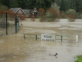
A series of storms have inundated California over the past few weeks, and the latest deluge is currently swelling rivers and reservoirs that are already spilling over. Vast swathes of California continue to be at risk for flooding as the storm runoff makes its way through river systems, the National Weather Service warns. Across California, residents were evacuated when local rivers flooded, including a small Northern California town that experienced a levee breach Monday night.
“So it appears that California may be due for another episode soon.”
The severe flooding may feel like a whiplash development in a state that’s been locked in drought for five years — and in an “exceptional drought” for three of them. Still, California has seen worse: massive floods have swept through the state about every 200 years for the past 2,000 years or more, climate scientists Michael Dettinger and Lynn Ingram recount in a 2013 article.
The most recent was a series of storms that lasted for a near-biblical 43 days between 1861 and 1862, creating a vast lake where California’s Central Valley had been. Floodwaters drowned thousands of people, hundreds of thousands of cattle, and forced the state’s government to move from Sacramento to San Francisco.
More than 150 years have passed since California’s last, great flood — and a team of researchers with the US Geological Survey have predicted what kind of damage a similar flood would cause today. Their simulation, called the ARkStorm, anticipates that a stretch of the Central Valley 300 miles long by 20 miles wide would be underwater. Cities up and down the coast of California would flood. Winds would howl 60 to 125 miles per hour, and landslides would make roads impassable.
Although the simulation didn’t include a body count, Dettinger and Ingram predicted that thousands of people would probably die. And it could happen again any time: it’s been 150 years since the 1861–1862 floods, they wrote. “So it appears that California may be due for another episode soon.”
This winter’s heavy precipitation has already caused a slew of problems; California’s governor Jerry Brown called a state of emergency after December and January’s storms to ensure that 50 counties would be able to get funds to repair the damage. Last week, the Oroville Dam’s crumbling emergency spillway triggered the emergency evacuation of more than 180,000 people.
Now, the state’s Department of Water Resources is turning its attention to the Don Pedro Dam in Tuolumne County, California — about two hours due west of Yosemite National Park. The dam operators opened the spillway Monday afternoon, which will mean higher water levels in the river system for a while, says Jon Ericson with the California Department of Water Resources. People who live along the Tuolumne River are being encouraged to move to higher ground, the LA Times reported on Monday.
“We’re really going to be very vigilant,” Ericson told The Verge on Monday. “We always are, but especially the next 24 to 48 hours there’s going to be quite a bit of water that’s going to be coming through the system.”
Though the impact has been extensive, Marty Ralph, the director of the Center for Western Weather and Water Extremes at the University of California, San Diego, doesn’t think that this latest storm is this century’s equivalent to the 1861–1862 floods. “They are the same type,” Ralph says. “But I don’t think that they’re the magnitude that that ARkStorm predicted.”
“It’s about the equivalent of 20 Mississippi Rivers’ worth of water.”
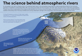
Both storms, Ralph says, are the result of an atmospheric river, first identified in 1998. An atmospheric river is a massive ribbon of water vapor that flows off the Pacific Ocean and combines with strong, low-altitude winds. They stretch about 250 to 375 miles across, but can reach from 1,000 to more than 2,000 miles in length. “It’s about the equivalent of 20 Mississippi Rivers’ worth of water, but it’s in the form of water vapor rather than liquid,” Ralph says. When it hits the coastal mountains, the stream of warm, wet air is forced upward, where it cools and condenses into massive rain clouds.
“It’s definitely a very unusually very wet year for us,” Ralph says, but he doesn’t think that it’s an ARkStorm type year. “Now that’s not to say that couldn’t happen, which would be highly tragic.”
 Infographic by NOAA
 In a typical year, around nine atmospheric rivers shower California with precipitation. They’re a critical source of about a third to half of the annual water in a state where the summers are usually bone-dry. But they also frequently go hand in hand with devastating wind storms, which can cause billions of dollars of damage, according to a study published Monday in the journal Nature Geosciences.
“When we get a sequence of them, or we get too many and the soils are real moist and the rivers are high and the reservoirs are full, then they can go from being largely beneficial — because we need water in the West — to hazards,” Ralph says.
That’s the situation we’re in now, Ralph says, with about 30 atmospheric rivers since October 1st — and it’s something we can expect to see more of. As global temperatures continue to climb, the air can hold more water vapor — which means calmer winds, but warmer and wetter atmospheric rivers, more often. And that means more flooding.
“This situation that we’re seeing with the pronounced drought punctuated by wet conditions that are producing a lot of runoff — that is exactly what we are seeing intensify in the historical record,” says Noah Diffenbaugh, a professor of Earth Sciences at Stanford University. “And it’s exactly what climate models project for the future.”
Climate change could exacerbate the dynamic as we struggle with an aging and already failing infrastructure. We can probably expect more, and worse catastrophes than Oroville’s crumbling spillway. That’s why Newsha Ajami, Stanford’s director of Urban Water Policy, says, “Coming up with new more innovative management and operational rules that reflect the 21st century climatic realities — I think that is really an important issue.”
The good news is that the weather seems to be calming down — for now. Over the past 48 hours, two to three inches of rain washed over the Sacramento valley and between five and eight inches fell in the Sierra Nevadas, Eric Kurth, a meteorologist with the National Weather Service, told The Verge. At least a foot of snow fell at higher mountain elevations, and more is expected. The winds have calmed down today, but yesterday they howled at 199mph through California’s mountain peaks. Thursday should bring a brief dry spell, but more typical, cold winter weather will follow.
“The good part, though, is that the more precipitation that we get in the form of snow, the less is running off into streams and rivers and creeks, so it’s definitely much less of a flood issue,” Kurth says. Still, he adds, there could be some ongoing flooding in California’s Central Valley. “The ground is saturated, and creeks and rivers are high, so adding anything additional could always cause some problems.”


