By Jason Samenow September 26 at 3:16 PM

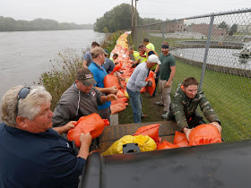
Jason Mann, of Cedar Rapids, Iowa, loads sandbags onto a truck in the New Bohemia District, on Sept. 23. (David Scrivner /Iowa City Press-Citizen via AP)
Over the past week, thunderstorms have repeatedly dumped heavy rain in southeast Minnesota, northeast Iowa and west central Wisconsin. Widespread rainfall amounts of 5 to 10 inches have drenched the region.
As these torrents flow downriver through the eastern half of Iowa, the region is bracing for a flood event nearing historic levels.

Estimated rainfall over last week in southeast Minnesota, northeast Iowa, and west central Wisconsin. (National Weather Service)
The area of greatest concern is around Cedar Rapids, Iowa’s second largest city, where the Cedar River is expected to crest at 23.0 feet Tuesday morning into the afternoon, 11 feet above flood stage. This would mark the second highest level on record.
On Monday, the river level had reached 20 feet and was “quickly rising,” according to the National Weather Service.
Over 5,000 residents in Cedar Rapids near the river were strongly encouraged to evacuate the area Sunday evening. In anticipation of the floodwaters, Cedar Rapids City Manager Jeffrey Pomeranz tweeted that more than 250,000 sandbags and 9 miles of Hesco barriers were put in position.
“Temporary flood control measures have been constructed over the last 2-3 days in an effort to contain rising water, but are no guarantee of safety,” the city stated in a news release Monday afternoon. “Evacuation notices should be taken seriously. The public should not be walking, biking, or driving in the evacuation area, and should not go near or climb on the Hesco barriers and berms.”
The city is taking the flood threat especially seriously after floods in 2008 caused hundreds of millions of dollars in damages. The flood severely damaged 561 city blocks. During that flood, the Cedar River crested at over 31 feet.
While the 2008 flood will certainly be much more extensive than this year’s, officials are taking no chances.
“It’s crunchtime in Cedar Rapids,” said Mayor Ron Corbett during Monday’s flood briefing according to The Gazette, which serves eastern Iowa. “The next 48 hours are the most critical. The next 48 hours are the most dangerous. And the next 48 hours we need 100 percent cooperation from the citizens in both the evacuation area and outside the evacuation area.”
Schools are closed in the area through Wednesday.
Flooding in the region has been blamed for two deaths in Wisconsin.
Flood warnings were in effect along and adjacent to several other rivers in eastern Iowa, including the Wapsipinicon River, Iowa River and the main stem of the Mississippi River.
The Weather Service said “excessive amounts of water continue to flow downstream” through the Iowa River, which is forecast to crest mid-to-late week.
Along the Mississippi River, minor to major flooding is forecast, beginning in the next two days and affecting some areas later in the week.
Disaster emergencies were declared in 13 counties in both Iowa and Wisconsin so funding would be available for response efforts.
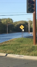
Below see video and imagery of flooding in the region from social media …


