Thursday, June 7, 2018

A BNSF train collided with a Herzog Railroad Services train pushing maintenance equipment in a remote canyon near Truxton, AZ killing 63-year-old Walter Erickson and injured another railroad worker

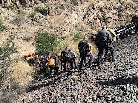
First responders work together to get Matthew Thompson, 26, of Salem, Missouri, away from the train wreckage so he could airlifted to a Las Vegas hospital. (Photo courtesy of Mohave County Sheriff's Office)


The Latest: Name Released of Man Killed in Crash of 2 Trains
Authorities have released the name of a man killed and another man injured in the crash of two trains in northwestern Arizona.


June 6, 2018


TRUXTON, Ariz. (AP) — The Latest on a railroad wreck in northwestern Arizona (all times local):


5:40 p.m.


Authorities have released the name of a man killed and another man injured in the crash of two trains in northwestern Arizona.


Mohave County Sheriff's officials say a Burlington Northern Santa Fe Railway train collided Tuesday afternoon with a Herzog Railroad Services train pushing maintenance equipment in a remote canyon near Truxton 103 miles (166 kilometers) west of Flagstaff.


Sheriff's officials say 63-year-old Walter Erickson of Lenexa, Kansas, was pronounced dead at the scene.


They say another Herzog employee — 26-year-old Matthew Thompson of Salem, Missouri — was airlifted to a Nevada hospital with serious injuries and is listed in stable condition.


Authorities say all occupants of the BNSF train were accounted for and no other injuries were reported.


BNSF spokeswoman Lena Kent says the National Transportation Safety Board will investigate the cause of the crash, which left the BNSF freight train with significant front-end damage and derailed several cars on the Herzog train.


____


12:45 p.m.


A fatal collision between two BNSF Railway trains on the freight railroad's tracks in northwestern Arizona forced Amtrak to use charter buses to carry train passengers between Flagstaff and Los Angeles.


The Mohave County Sheriff's Office said one person was killed and another injured in the wreck, which occurred Tuesday near Truxton, Arizona, which is 103 miles (166 kilometers) west of Flagstaff.


No identities were released, and BNSF spokeswoman Lena Kent declined to say whether the people killed or injured in the wreck in rural Mohave County were BNSF employees.


Amtrak spokesman Marc Magliari said Wednesday the busing of passengers on the passenger railroad's Southwest Chief route between Chicago and Los Angeles will continue until BNSF reopens its tracks at the wreck site.


___


9:20 a.m.


BNSF Railway says its southern mainline between Southern California and Chicago remained shut down Wednesday in northwestern Arizona because of a two-train collision in which one person was killed and another injured.


No identities were released and BNSF spokeswoman Lena Kent declined to say whether the people killed or injured in the wreck near Tuesday in rural Mohave County were employees.


She also declined to provide any information about the circumstances of the wreck but said one locomotive was left derailed but upright and that two cars also were derailed.


Kent said the National Transportation Safety Board will investigate the incident. An NTSB spokesman did not immediately respond to requests for information.


The wreck occurred near Truxton, which is 103 miles (166 kilometers) west of Flagstaff.


___


7:10 a.m.


Authorities say one person was killed and a second injured when two freight trains collided on BNSF Railway tracks in northwestern Arizona.


A BNSF spokeswoman did not immediately respond to requests for information but the Mohave County Sheriff's Office says the collision occurred Tuesday near the small community of Truxton and that deputies reported that one train derailed and that the other had "significant damage."


The Sheriff's Office said the National Transportation Safety Board was notified of the wreck and is "involved in the investigations."


An NTSB spokesman did not immediately respond to a request for information, and sheriff's spokeswoman Anita Mortensen said no information is available about the people who were killed or injured and circumstances of the wreck.


Truxton is 103 miles (166 kilometers) west of Flagstaff. 


=========================


TRUXTON, AZ – 


One man died and another suffered serious injuries from a train collision Tuesday afternoon in a remote canyon, Mohave County Sheriff’s Office reported.

Walter Erickson, 63, of Lenexa, Kansas, was pronounced dead upon arrival. Matthew Thompson, 26, of Salem, Missouri, was airlifted to University Medical Center in Las Vegas, where he was listed in stable condition.

Deputies were called out to the accident around 3 p.m. Tuesday and saw one train belonging to Burlington Northern Santa Fe Railway with significant front-end damage.

The other train had been pushing maintenance equipment belonging to Herzog Railroad Services, and the equipment had been derailed. Both the deceased and injured man were Herzog employees.

All occupants of the BNSF train were accounted for and no other injuries were reported.

Sheriff Doug Schuster expressed condolences to the family, and said circumstances contributing to the cause of the accident will be investigated by the National Transportation Safety Board.

“Mohave County Sheriff’s Office is here to support NTSB in the investigation of the accident and will be conducting our own independent investigation regarding the loss of life,” Schuster said in a statement.

The sheriff thanked the Arizona Department of Public Safety, American Medical Response, Hualapai Nation Emergency Services, Mohave County and Arizona Department of Transportation for their support.

Information provided by MCSO

ORIGINAL POST

TRUXTON, AZ - One man was dead on scene and another was airlifted by Department of Public Safety Ranger Helicopter after a train collision outside of Truxton near mile marker 91 on Route 66 Tuesday afternoon, according to Mohave County Sheriff's Department and Hualapai Nation Emergency Services.

When MCSO deputies arrived on scene, one train was derailed and another received significant damage.

Hualapai Nation Emergency Services responded with police, fire, adult detention and code enforcement personnel and equipment. Along with DPS and MCSO, BNSF police were on scene.

The investigation is ongoing. National Transportation Safety Board has been notified.


Information provided by Mohave County Sheriff's Department and Hualapai Nation Emergency Services
NTSB releases a preliminary report on the fatal accident involving a Tesla Model X on Autopilot in March 2018


  • Accident No: HWY18FH011
  • Accident Type: Office of Highway Safety
  • Location: Mountain View, CA
  • Date: 3/23/2018

A fatal accident involving a Tesla Model X on Autopilot came under investigation by the U.S. National Transportation Safety Board (NTSB) in March.

The NTSB has now released its preliminary report of the accident.

After the accident, which took the life of the driver, had gathered a lot of media attention and scrutiny from the NTSB, Tesla released a detailed report of what it thought happened based on the vehicle’s data logs.

The NTSB corroborated the sequences of events leading to the crash with its own review of the recorded performance data: 


The Autopilot system was engaged on four separate occasions during the 32-minute trip, including a continuous operation for the last 18 minutes 55 seconds prior to the crash.
During the 18-minute 55-second segment, the vehicle provided two visual alerts and one auditory alert for the driver to place his hands on the steering wheel. These alerts were made more than 15 minutes prior to the crash.


During the 60 seconds prior to the crash, the driver’s hands were detected on the steering wheel on three separate occasions, for a total of 34 seconds; for the last 6 seconds prior to the crash, the vehicle did not detect the driver’s hands on the steering wheel.


At 8 seconds prior to the crash, the Tesla was following a lead vehicle and was traveling about 65 mph.


At 7 seconds prior to the crash, the Tesla began a left steering movement while following a lead vehicle.


At 4 seconds prior to the crash, the Tesla was no longer following a lead vehicle.


At 3 seconds prior to the crash and up to the time of impact with the crash attenuator, the Tesla’s speed increased from 62 to 70.8 mph, with no precrash braking or evasive steering movement detected.

The report also addresses the response to the battery fire that followed the crash and the fact that the battery pack reignited days later.

The preliminary report doesn’t determine the probable cause of the accident and instead mainly lists the findings to date.

The NTSB wrote:


The NTSB continues to work with the California Highway Patrol and the California Department of Transportation to collect and analyze data, including all pertinent information relating to the vehicle operations and roadway configuration. All aspects of the crash remain under investigation as the NTSB determines the probable cause, with the intent of issuing safety recommendations to prevent similar crashes.​

Here’s NTSB’s full preliminary report of the accident:


View this document on Scribd

A Tesla spokesperson pointed you back to Tesla’s previously mentioned blog about the accident and declined to comment further.

Preliminary Report- Highway: Collapse of Pedestrian Bridge Under Construction Miami, Florida (HWY18MH009)

Preliminary Report- Highway: Collapse of Pedestrian Bridge Under Construction Miami, Florida (HWY18MH009)

Executive Summary

The information in this report is preliminary and will be supplemented or corrected during the course of the investigation.
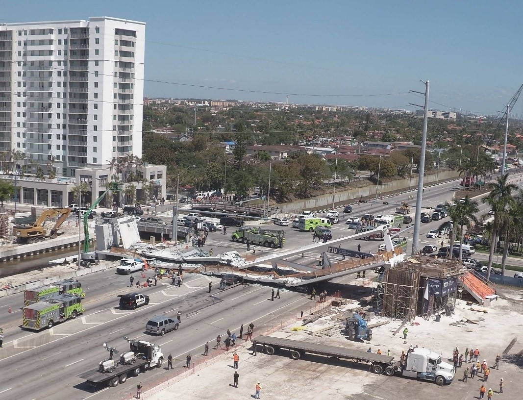
On Thursday, March 15, 2018, about 1:47 p.m. eastern daylight time, a partially constructed pedestrian bridge crossing SW 8th Street—an eight-lane roadway—in Miami, Florida, experienced a structural failure.[1]  As a result, the 174-foot-long bridge fell about 18.5 feet onto SW 8th Street (figure 1). Eight vehicles that were stopped below the bridge at the time of the collapse were fully or partially crushed; seven of those vehicles were occupied. As a result of the bridge collapse, one bridge worker and five vehicle occupants died. Four bridge workers and four other people were injured.
Figure 1. View of collapsed pedestrian bridge. 
 Figure 1. View of collapsed pedestrian bridge. (Source: Florida International University)

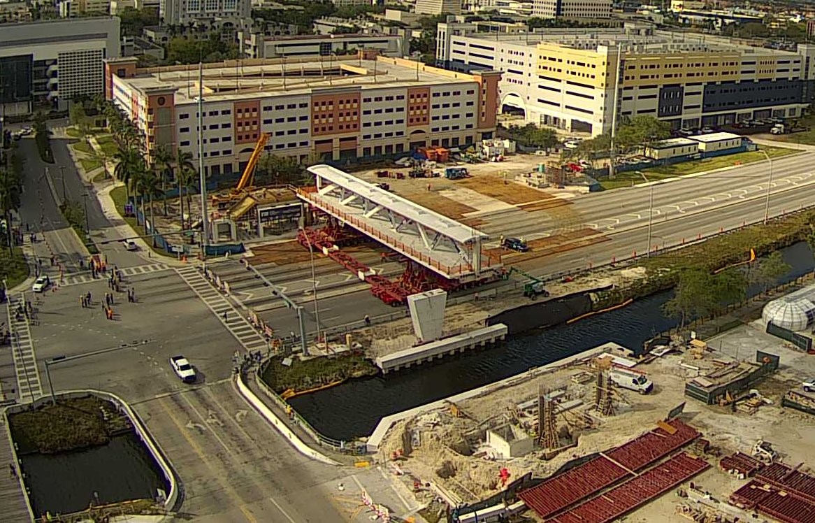
The bridge was to be completed by early 2019 and was built using an accelerated bridge construction method—a technique intended to minimize disruption of traffic. On March 10, 2018, the walkway, diagonals, and canopy comprising the bridge, which had been built in a lot adjacent to SW 8th Street, was moved from the lot, using transporters, into position across the roadway and then lowered onto bridge piers on either side of the roadway (figure 2).[2]  Traffic on SW 8th Street was detoured during the installation period, and the entire roadway was closed to facilitate movement of the structure.
Figure 2. View of transporters moving the pedestrian bridge into place on the bridge piers. 
Figure 2. View of transporters moving the pedestrian bridge into place on the bridge piers.
(Source: Florida International University)

On March 10 per the bridge design plans, construction crew members de-tensioned the bridge diagonal members on the north and south ends of the bridge. When the collapse occurred on March 15, a construction crew was positioned on the structure working on re-tensioning the number 11 diagonal member connecting the canopy and the deck at the north end of the bridge. Because a crane was being used for this work, two of the three westbound lanes below the north end of the bridge were closed to traffic; however, the five eastbound lanes remained open, and eastbound traffic was not detoured.
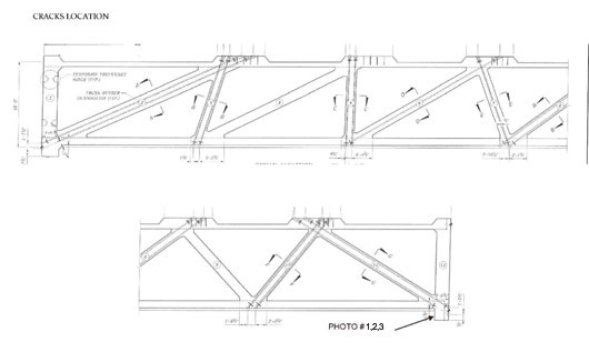
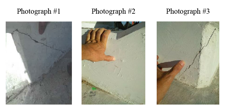
The NTSB is evaluating the bridge design, the construction process, and the construction materials.  In addition, the NTSB is evaluating the emergence of cracks in the region of diagonal members 2 (south end of the bridge) and 11 (north end of bridge), see figure 3, and the propagation of cracks in the region of diagonal member 11. Photographic documentation from February 24, 2018 shows cracks in the region of diagonal member 11 (figure 4).
Figure 3. Elevation view of the pedestrian bridge. 
 
Figure 3. Elevation view of the pedestrian bridge.
(Source: Bolton-Perez and Associates Consulting Engineers)
Figure 4. Photographic documentation of the crack in the region of bridge diagonal 11.
(Source: Bolton-Perez and Associates Consulting Engineers)
In the next month, the NTSB will be conducting additional forensic examination of several bridge structural components and destructive testing of multiple core and steel samples. All aspects of the collapse remain under investigation while the NTSB determines the probable cause, with the intent of issuing safety recommendations to prevent similar events.
Assisting in the NTSB investigation are the following Party Members;
  • Federal Highway Administration (FHWA)
  • FHWA - Turner Fairbank Highway Research Center (TFHRC
  • Occupational Health and Safety Administration (OSHA)
  • Department of Transportation Office of the Inspector General (OIG)
  • Florida Department of Transportation (FDOT)
  • Miami-Dade Police Department (MDPD)
  • Florida Highway Patrol (FHP)
  • Florida International University (FIU)
  • City of Sweetwater (CS)
  • FIGG Bridge Engineers, Inc. (FIGG)
  • Munilla Construction Management (MCM)
  • Structural Technologies, LLC (VSL)
  • Barnhart Crane & Rigging (BCR)

 
1. The eight-lane roadway consisted of four through travel lanes and one left turn lane in the eastbound direction, and three through travel lanes in the westbound direction.
2. “Transporters” are devices designed to move the structure into place.
Probable Cause

​​The information in this report is preliminary and will be supplemented or corrected during the course of the investigation.

An Uber Technologies, Inc. test vehicle, based on a modified 2017 Volvo XC90 and operating with a self-driving system in computer control mode, struck a pedestrian on northbound Mill Avenue, in Tempe, Maricopa County, Arizona

Preliminary Report Highway: HWY18MH010

Executive Summary

The information in this report is preliminary and will be supplemented or corrected during the course of the investigation.

About 9:58 p.m., on Sunday, March 18, 2018, an Uber Technologies, Inc. test vehicle, based on a modified 2017 Volvo XC90 and operating with a self-driving system in computer control mode, struck a pedestrian on northbound Mill Avenue, in Tempe, Maricopa County, Arizona. The Uber test vehicle was occupied by one vehicle operator, a 44-year-old female. No passengers were in the vehicle.

In the area of the crash, northbound Mill Avenue consists of two left-turn lanes, two through lanes, and one bike lane. The crash occurred before the formation of a right-turn lane. Roadway lighting was present. The posted speed limit was 45 mph.
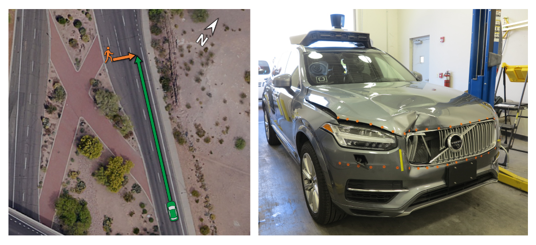
The crash occurred as the pedestrian, a 49-year-old female, walked a bicycle east across Mill Avenue. The Uber test vehicle was traveling in the right through lane when its right front side struck the pedestrian (see figure 1). As a result of the crash, the pedestrian died. The vehicle operator was not injured.

In this area, northbound Mill Avenue is separated from southbound Mill Avenue by a center median containing trees, shrubs, and brick landscaping in the shape of an X. Four signs at the edges of the brick median, facing toward the roadway, warn pedestrians to use the crosswalk. The nearest crosswalk is at the intersection of Mill Avenue and Curry Road, about 360 feet north of where the crash occurred.
image of location of crash on left, image of damaged Uber vehicle on right 
Figure 1. (Left) Location of the crash on northbound Mill Avenue, showing the paths of the pedestrian in orange and of the Uber test vehicle in green. (Right) Postcrash view of the Uber test vehicle, showing damage to the right front side.  

Uber had equipped the test vehicle with a developmental self-driving system. The system consisted of forward- and side-facing cameras, radars, LIDAR, navigation sensors, and a computing and data storage unit integrated into the vehicle.[1]  Uber had also equipped the vehicle with an aftermarket camera system that was mounted in the windshield and rear window and that provided additional front and rear videos, along with an inward-facing view of the vehicle operator. In total, 10 camera views were recorded over the course of the entire trip.

The self-driving system relies on an underlying map that establishes speed limits and permissible lanes of travel. The system has two distinct control modes: computer control and manual control. The operator can engage computer control by first enabling, then engaging the system in a sequence similar to activating cruise control. The operator can transition from computer control to manual control by providing input to the steering wheel, brake pedal, accelerator pedal, a disengage button, or a disable button. 

The vehicle was factory equipped with several advanced driver assistance functions by Volvo Cars, the original manufacturer. The systems included a collision avoidance function with automatic emergency braking, known as City Safety, as well as functions for detecting driver alertness and road sign information. All these Volvo functions are disabled when the test vehicle is operated in computer control but are operational when the vehicle is operated in manual control.

According to Uber, the developmental self-driving system relies on an attentive operator to intervene if the system fails to perform appropriately during testing. In addition, the operator is responsible for monitoring diagnostic messages that appear on an interface in the center stack of the vehicle dash and tagging events of interest for subsequent review.
On the night of the crash, the operator departed Uber’s garage with the vehicle at 9:14 p.m. to run an established test route. At the time of the crash, the vehicle was traveling on its second loop of the test route and had been in computer control since 9:39 p.m. (i.e., for the preceding 19 minutes).

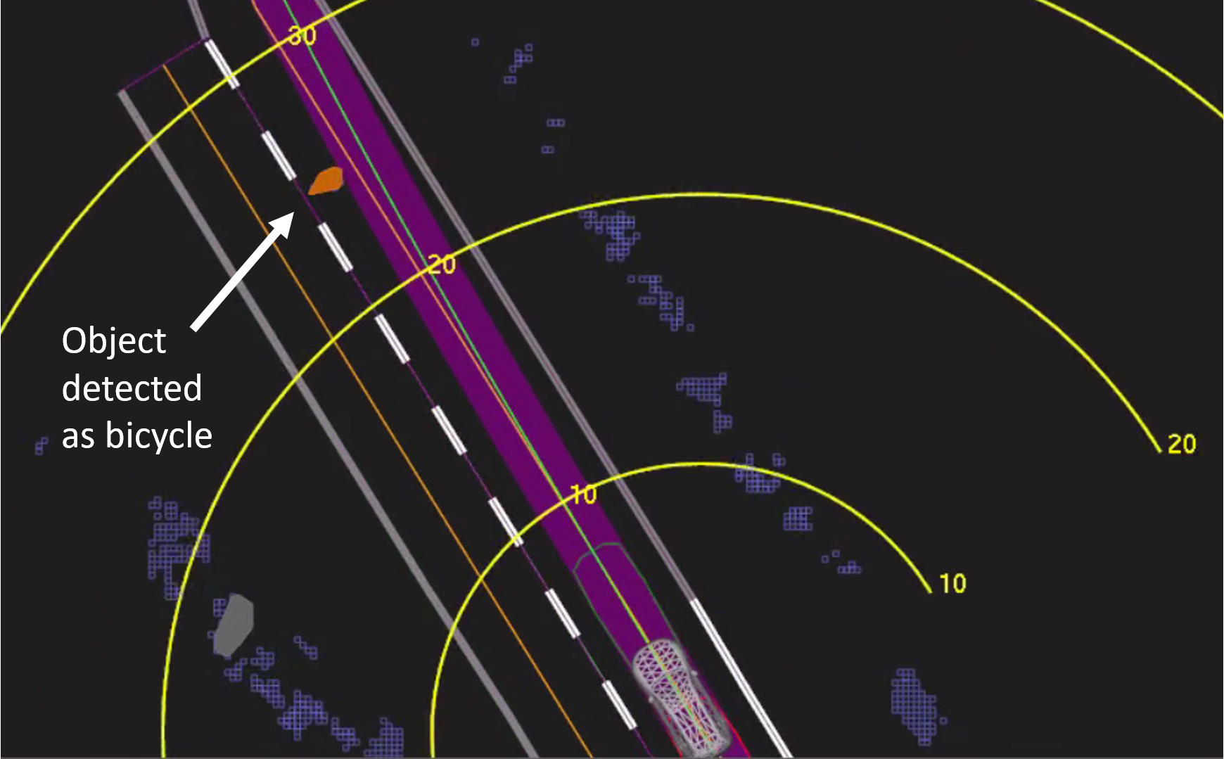
According to data obtained from the self-driving system, the system first registered radar and LIDAR observations of the pedestrian about 6 seconds before impact, when the vehicle was traveling at 43 mph. As the vehicle and pedestrian paths converged, the self-driving system software classified the pedestrian as an unknown object, as a vehicle, and then as a bicycle with varying expectations of future travel path. At 1.3 seconds before impact, the self-driving system determined that an emergency braking maneuver was needed to mitigate a collision (see figure 2).[2]  According to Uber, emergency braking maneuvers are not enabled while the vehicle is under computer control, to reduce the potential for erratic vehicle behavior. The vehicle operator is relied on to intervene and take action. The system is not designed to alert the operator.
View of the self-driving system data playback at about 1.3 seconds before impact. 
Figure 2. View of the self-driving system data playback at about 1.3 seconds before impact, when the system determined an emergency braking maneuver would be needed to mitigate a collision. Yellow bands are shown in meters ahead. Orange lines show the center of mapped travel lanes. The purple shaded area shows the path the vehicle traveled, with the green line showing the center of that path.
  
The self-driving system data showed that the vehicle operator intervened less than a second before impact by engaging the steering wheel. The vehicle speed at impact was 39 mph. The operator began braking less than a second after the impact. The data also showed that all aspects of the self-driving system were operating normally at the time of the crash, and that there were no faults or diagnostic messages.  

Several Uber self-driving system cameras captured the crash event. The videos were reviewed by the NTSB and the parties to the investigation. The forward-facing videos show the pedestrian coming into view and proceeding into the path of the vehicle. The videos also show that the pedestrian, once visible, did not look in the direction of the vehicle until just before impact. The videos show that the pedestrian was dressed in dark clothing and that the bicycle did not have any side reflectors. The bicycle had front and rear reflectors and a forward headlamp, but all were facing in directions perpendicular to the path of the oncoming vehicle. The videos show that the pedestrian crossed in a section of roadway not directly illuminated by the roadway lighting.

The inward-facing video shows the vehicle operator glancing down toward the center of the vehicle several times before the crash. In a postcrash interview with NTSB investigators, the vehicle operator stated that she had been monitoring the self-driving system interface. The operator further stated that although her personal and business phones were in the vehicle, neither was in use until after the crash, when she called 911.

The NTSB continues to gather information on the Uber self-driving system, the vehicle interface, and the driver’s personal and business cell phones. Although toxicological specimens were not collected from the vehicle operator, responding officers from the Tempe Police Department stated that the vehicle operator showed no signs of impairment at the time of the crash.

The NTSB continues to gather information on the pedestrian and is seeking information from anyone who might be aware of her activities before the crash. Those with information should contact the NTSB by email at witness@ntsb.gov. Toxicology test results for the pedestrian were positive for methamphetamine and marijuana.

All aspects of the crash remain under investigation as the NTSB determines the probable cause, with the intent of issuing safety recommendations to prevent similar crashes. The NTSB is working with the parties to the investigation—Uber, Volvo Cars, and the Arizona Department of Transportation—to compile a complete and accurate account of the crash.

1. Light Detection and Ranging (LIDAR) works much like radar, but instead of radio waves, it emits pulses of infrared light and measures how long they take to return after hitting nearby objects. Navigation sensors monitor global positioning system (GPS), inertia, and wheel speed.
2. In Uber’s self-driving system, an emergency brake maneuver refers to a deceleration greater than 6.5 meters per second squared (m/s2).

Probable Cause

​The information in this report is preliminary and will be supplemented or corrected during the course of the investigation.

By ruling out other causes, the fatal fire in Dartmouth likely caused by improper disposal of smoking materials

A backhoe propped up the badly damaged roof of a Dartmouth apartment building Monday as investigators examined burned-out units, trying to determine the cause of a weekend fire that killed one person, sent another to hospital and displaced about 150 tenants.


Halifax Regional Fire & Emergency has closed its investigation into a May 19 fatal fire at an apartment building on Primrose Street. Alexa MacLean/Global News

Fatal fire in Dartmouth ‘likely’ caused by careless use of smoking materials
By Alexander Quon Online Producer/Reporter Global News

Halifax Regional Fire & Emergency said last month’s fatal apartment fire in Dartmouth was likely the result of careless use of smoking materials.

Fire investigators say they use the term “likely” in describing the source of the fire because, in this case, the official cause is undetermined.

“We look at the entire history of the building, what witnesses tell us about that apartment and what occurred, and that’s why we believe (improper disposal of smoking materials) occurred,” said Deputy Fire Chief Roy Hollett on Wednesday.

The fire reportedly began on May 19, at around 3:30 a.m., and was large enough that roughly 40 firefighters were on scene for most of a day to battle the blaze and stabilize the structure after a portion of the roof collapsed.

Investigators say the origin of the fire was a third-floor apartment unit living room near the couch. Hollett says the cause of the fire was determined by ruling out other potential causes.

“We ruled out electrical … we start from what we know and what we don’t know, and we try to come to somewhere in the middle that gives us a story as to what happened,” said Hollett.

The name, age and gender of the deceased has not been released, but Hollett said the victim lived where the fire started.

Fire investigators are urging the public to be vigilant in the use and disposal of all smoking materials.

Dartmouth community pulls together following devastating fires 


The May 19 fire wasn’t the only one that shook members the north-end Dartmouth community. Just hours after the Primrose Street fire, another apartment building broke out into flames on Brule Street.

Officials have since deemed the Brule Street fire not suspicious and say there isn’t a connection between the two.

When mother nature spilled her fiery guts, Kapoho Bay became Kaput Bay


A slow-moving flood of lava destroyed hundreds of homes in the southeast area of Big Island, turning what had been a scenic bay dotted with beach homes, lush greens and turquoise waters, into a dark slab of steam and lava.


By Tuesday morning, the lava had completely filled Kapoho Bay -- shocking residents and frequent visitors who realized that their beloved bay was gone. It was where vacationers enjoyed tide pools, snorkeling and picnics, reported CNN affiliate Hawaii News Now.


As of the morning of June 5, the fissure 8 lava flow front had completely filled Kapoho Bay.


"It's incredibly saddening," Jason Hills, who makes a yearly visit, told the station. "Kapoho Bay was just a little calm water gem where people could play, swim, hang out in the tide pools. It was green and beautiful, great trade winds, and now it's just a big hunk of lava rock."

A satellite image from 2016 shows Kapoho Bay on the island of Hawaii before the Kilauea volcano erupted, and an image taken on June 4, 2018 with lava spilling into the bay.

So far, it was unclear how many homes have been affected, but Hawaii Civil Defense Administrator Talmadge Magno said it was fair to say it was hundreds. The lava pushed into beach lots in Kapoho, which has about 350 homes and Vacationland, which has about 150. This doesn't mean all homes were affected, but authorities will have to count and match the areas with property maps.

About 80% of the homes are believed to be vacation homes, Magno told reporters Tuesday.


Lava from one of the fissures entered Kapoho Bay late Sunday or early Monday, forcing billowing clouds of steam into the atmosphere as hot lava hit the cool water of the Pacific Ocean. Fissure 8 was very active overnight into Tuesday, producing large amounts of lava that destroyed homes. The lava flow extended 0.8 miles from the shore. 


"It's a slow-moving flood. Nothing stops it and the direction it goes," Magno said of the lava flow. "It continues its march to the ocean." 


Helicopter overflight on June 4, showed lava from fissure 8 entering the ocean at Kapoho Bay.


At least 12,000 earthquakes on Hawaii's Big Island in the last 30 days


Hawaii County Civil Defense authorities also warned about laze, a nasty mashup of lava and haze that sends hydrochloric acid and volcanic glass particles into the air. The large laze plume was blowing inland along the coastline and the agency warned residents to avoid the area. 


At least 117 homes have been destroyed since lava began flowing, Magno said, but this doesn't include those affected in Kapoho and Vacationland. 


=====================


Entire Hawaii neighborhood vanishes as lava gushes in


This satellite image provided by Digital Globe captured June 5, 2018, shows lava flows on most of Kapoho Bay in Hawaii. Lava from the Kilauea volcano destroyed hundreds of homes in a mostly rural area on the Big Island of Hawaii overnight. It's the largest number of destroyed homes since the eruption began last month. (Satellite Image ©2018 DigitalGlobe, a Maxar company via AP)
Associated Press


This image taken from video on Monday, June 4, 2018, and provided by the U.S. Geological Survey shows lava from a fissure flowing into the ocean at Kapoho Bay at Kapoho on the island of Hawaii. After overrunning the town overnight and destroying hundreds of homes, the lava flowed into the shallow bay and had nearly filled it. (U.S. Geological Survey via AP)
Associated Press


This image taken from video on Monday, June 4, 2018 and provided by the U.S. Geological Survey shows lava from a fissure flowing into the ocean at Kapoho Bay at the town of Kapoho on the island of Hawaii. See the structure at lower left for scale. The flow front was about a half-mile wide, with lava building a delta a few hundred yards into the bay. Hundreds of homes were destroyed overnight. (U.S. Geological Survey via AP)
Associated Press


This photo provided by the U.S. Geological Survey shows an early-morning view of Halema'uma'u Crater and the KÄ«lauea Caldera from the KÄ«lauea overlook at Hawaii Volcanoes National Park on the island of Hawaii, Tuesday, June 5, 2018. Heavy steam dominates the view, and strong winds are blowing the plume to the southwest. (U.S. Geological Survey via AP)
Associated Press


This satellite image provided by Digital Globe captured June 5, 2018, shows Kilauea summit crater in Hawaii. Lava from the Kilauea volcano destroyed hundreds of homes in a mostly rural area on the Big Island of Hawaii overnight. It's the largest number of destroyed homes since the eruption began last month. A spokeswoman for Hawaii County says an exact count of destroyed homes has yet to be determined. (Satellite Image ©2018 DigitalGlobe, a Maxar company via AP)
Associated Press


This satellite image provided by Digital Globe captured June 3, 2018, shows advancing lava flows as they approach Kapoho Bay in Hawaii. Lava from the Kilauea volcano destroyed hundreds of homes in a mostly rural area on the Big Island of Hawaii overnight. It's the largest number of destroyed homes since the eruption began last month. A spokeswoman for Hawaii County says an exact count of destroyed homes has yet to be determined. (Satellite Image ©2018 DigitalGlobe, a Maxar company via AP)
Associated Press


This satellite image provided by Digital Globe captured June 5, 2018, shows lava flows on most of Kapoho Bay in Hawaii. Lava from the Kilauea volcano destroyed hundreds of homes in a mostly rural area on the Big Island of Hawaii overnight. It's the largest number of destroyed homes since the eruption began last month. (Satellite Image ©2018 DigitalGlobe, a Maxar company via AP)
Associated Press


This image taken from video on Monday, June 4, 2018, and provided by the U.S. Geological Survey shows lava from a fissure flowing into the ocean at Kapoho Bay at Kapoho on the island of Hawaii. After overrunning the town overnight and destroying hundreds of homes, the lava flowed into the shallow bay and had nearly filled it. (U.S. Geological Survey via AP)
Associated Press


By CALEB JONES 


HONOLULU -- A neighborhood called Vacationland on Hawaii's Big Island had disappeared by Wednesday as lava poured into two oceanfront subdivisions, smothering hundreds of homes and filling an ocean bay, turning it into new land that now juts into the sea.

Molten rock entirely covered Vacationland and only a few buildings remained in the nearby Kapoho subdivision, officials with the U.S. Geological Survey said.

"The bay is completely filled in and the shoreline is at least 0.8 miles out from its original location," said Geological Survey geologist Wendy Stovall. "Vacationland is gone, there is no evidence of any properties there at all. On the northern end of that, there are just a few homes in the (Kapoho) beach lots area."

Resident Mark Johnson is hopeful that his home on a citrus farm is one of those still standing. His ocean-view property sits on a ridge near the base of Kapoho crater, and he thinks the lava could have missed it.

"Basically we are up on that hill, so we're still OK right now," Johnson said.

But he has resigned himself to the possibility that he could lose his beloved farm, which he can't access even if lava doesn't cover it. The property isn't far from a crater lake that the approaching flow vaporized days before entering his neighborhood.

"I'm kind of at peace, actually," Johnson said of potentially losing his home of 28 years. "I feel that I've had a really great experience."

County officials said the two subdivisions have 279 homes, and most are feared destroyed from the most recent lava flows in the low-laying area.

"Over the course of essentially two days, that entire area was covered by lava," Stovall said.

Molten rock from the erupting Kilauea volcano already has destroyed at least 117 homes in the Lanipuna Gardens and Leilani Estates neighborhoods where lava surfaced more than a month ago. The total number of homes destroyed in the eruption stands at about 400.

Scientists are still recording vigorous volcanic activity. While only one crack in the ground is spewing molten rock and the height of fountaining lava has decreased in recent days, "it's still really impossible to tell," when it will end, Stovall said.

The lava inundation is among the most destructive and costly in volcano property loss in U.S. history. While no one has been killed and only one lava-related injury has been reported, the number of destroyed homes dwarfs other recent American eruptions.

It comes as a volcano erupted in Guatemala on Sunday and left 99 dead and nearly 200 missing.

In Hawaii, previous eruptions have destroyed small towns, but nothing on the scale of this outbreak. Lava flows destroyed homes and other buildings in the same area in 1955 and 1960, but the town of Kapoho was less densely populated at that time.

Between 1983 and 2014, a Kilauea eruption razed homes in and around the town of Kalapana. Over the course of about eight months in 1990, 214 homes were destroyed in that area. One home was lost in a separate 2014 lava flow in the commercial hub of Pahoa.

Even major explosive eruptions like that of Washington state's Mount St. Helens in 1980 didn't result in the same number of homes lost. That volcano and others in the region that have had recent eruptions are very remote with few people living nearby.

At Kilauea's summit, increased earthquake activity has led to explosive eruptions, some of which have shot rock and ash high into the air.

"We expect larger explosions will continue at the summit," Stovall said Wednesday.

Jessica Ferracane, spokeswoman for Hawaii Volcanoes National Park, was on the summit Wednesday and said three "sizable" earthquakes hit in the two hours she was there.

"It's a beautiful blue day, but it really seems eerie up there, lots and lots of ash covering areas near Jagger Museum and the earthquakes really make things seem very unsettled," she said.

Tree care worker Jason Covert-Kohler with Out on a Limb Tree Care Inc., of Dover, PA died from blunt force head and neck trauma after a tree fell on him in northern York County, PA


Tree company employee dies after tree falls on him
Updated Jun 5; Posted Jun 5


By The Associated Press


WARRINGTON, Pa. (AP) -- Authorities say a worker with a tree care company was killed when a tree fell on him at a Pennsylvania home.

The York County Coroner's Office says Jason Covert-Kohler was working with other company employees when the accident occurred around 2:30 p.m. Monday in Warrington. The 35-year-old Dover man was taken to a hospital but died there a short time later.

Authorities say Covert-Kohler died from blunt force head and neck trauma. His death has been ruled an accident.

No other injuries were reported in the accident. But authorities say it's not yet known what caused it.

According to the York Daily Record, the man worked for Out on a Limb Tree Care Inc. of Dover, and the incident has been reported to the Occupational Safety and Health Administration.


=====================


Dover man dies after tree falls on him, York County coroner says
Ted Czech, tczech@ydr.com 

June 5, 2018


Here are the latest top headlines from York County, Pennsylvania and the region. York Daily Record

Jason Covert-Kohler, 35, of the first block of North Main Street, Dover, died at York Hospital, according to York County Coroner Pam Gay.


A man employed by a tree care company died at York Hospital on Monday after a tree fell on him in northern York County, according to York County Coroner Pam Gay.

Despite efforts to save his life, Jason Covert-Kohler, 35, of the first block of North Main Street, Dover, died at the hospital at 3:42 p.m. the same day, Gay said.

Covert-Kohler, along with other employees of Out on a Limb Tree Care Inc., of Dover, was working in the 1000 block of Twin Lakes Road, Warrington Township, when a tree fell on him about 2:30 p.m., Gay said.

An ambulance crew arrived and transported an unresponsive Covert-Kohler to the hospital.

Gay said Covert-Kohler's cause of death was blunt force head and neck trauma and his manner of death was accidental. There will be no autopsy, she said.

The incident was reported to the Occupational Safety and Health Administration, Gay said.

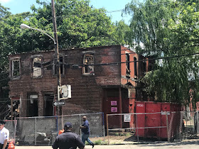
59-year-old demolition worker Harvey Lee Figgs with Gama Wrecking Co., died after the floor collapsed in a row home in the Brewerytown section of Philadelphia, PA


59-year-old demolition worker Harvey Lee Figgs with Gama Wrecking  Co., died after the floor collapsed in a row home in the Brewerytown section of Philadelphia, PA


1 Demolition Worker Killed In Brewerytown Building Collapse
June 4, 2018 at 11:41 pm


PHILADELPHIA, PA (CBS) — A demolition worker was killed following a building collapse of a row home in the Brewerytown section of Philadelphia on Monday morning.


The fire department was called out to the 2600 block of Jefferson Street for a building collapse around 10:50 a.m. for reports of two people trapped. Demolition crews from Gama Wrecking were working on the building when it came down.


The Philadelphia Fire Department responds to a building collapse in the Brewerytown section of the city. (credit: CBS3)

Police say two contractors were working on the building when the rear of the property collapsed, trapping them. One person was able to escape while the other, a 60-year-old man, was trapped under the rubble. He was pronounced dead shortly after 11 a.m.

The family identified the victim as 59-year-old Harvey Lee Figgs. His family had just celebrated his birthday on Sunday.


Video from Chopper 3 showed firefighters pulling one person from the rubble.

Jomo Day saw the row home fall and rushed to help a man trapped under the debris. 
“I ran over to try to help him there but it was too late,” said Day.

Figgs was in the back of the building, taking it apart brick-by-brick. Crews say that’s procedure when dealing with a row home like this that’s attached to other homes, but the floor beneath Figgs suddenly fell and the building collapsed on top of him.

“Real good guy, real good guy, give you the shirt off his back,” said Wayne Johnson. “It’s crazy, you’re here today, gone tomorrow.”

Authorities say a second crew member was inside at the home but able to escape and did not need any medical treatment. Investigators are now working to determine what lead up to the collapse.

“Buildings are complex structures, so it’s going to take some time to find exactly what the cause was,” said Philadelphia Fire Department Commissioner Adam Thiel.

Licenses and Inspections says the contractor did have a permit to demolish the structure, but some people are questioning how another deadly building collapse could happen, especially when Tuesday is five years since six people lost their lives in the Salvation Army building collapse on Market Street.

One of the demolition workers obtained an attorney who says it’s difficult to know what went wrong until investigators release more information, but he believes Figg’s death was likely preventable.

“I’m literally sickened to my stomach to see another collapse here in the city. It’s unbelievable to me,” said attorney Steve Wrigrizer. “This kind of thing could only happen if there is a flaw in the engineering survey that has to take place or a failure to execute the demolition plan properly.” 
The building is still deemed unstable.

Fire department officials are investigating.


==================================
Worker dies in building collapse in Brewerytown
Incident comes nearly five years to the day after tragedy at Salvation Army thrift store

By PhillyVoice staff


This home under demolition in the 1500 block of North Bailey Street partially collapsed Monday morning, Philadelphia fire officials reported. One worker died in the accident.


A worker was trapped and killed Monday when a two-story home under demolition in the Brewerytown section of Philadelphia partially collapsed.

The man was one of two workers at the building in the 1500 block of North Bailey Street around 11 a.m. when the rear of the structure collapsed, fire officials told the Associated Press.

One of the workers was able to escape the debris, but a 60-year-old man became trapped and was pronounced dead shortly after the collapse. He was not immediately identified.


In a Twitter post, the fire department said "our thoughts and prayers are with the community."

Fire commissioner Adam Thiel said the building remains unstable. The city's L&I Department is investigating the cause of the collapse.

Nearly five years ago to the day, on the morning of June 5, 2013, a building undergoing demolition collapsed onto the neighboring Salvation Army thrift store at 22nd and Market streets in Center City. Six people died and fourteen others were injured.

On Tuesday, from 11 a.m. to noon, the June 5th Memorial Park will be dedicated to the memory of those who lost their lives in the accident.


=======================


House Collapse Kills One Monday Morning In Philadelphia
Breaking: One construction worker died after the Brewerytown home collapsed during demolition work Monday morning.
By Max Bennett, Patch Staff | Jun 4, 2018


PHILADELPHIA – A construction worker reportedly died after a two-story rowhome collapsed during demolition work in Philadelphia's Brewerytown neighborhood Monday morning, according to officials.

The collapse happened on the 1500 block of Bailey Street at 10:50 a.m. Monday, June 4, the Philadelphia Fire Department said.

Fire officials said crews were called to the area and found one of the workers had pulled himself from the rubble, but one remained trapped.

The worker who pulled himself from the rubble did not need medical treatment, according to fire officials.

Crews pulled the trapped worker from the debris after about 15 minutes of many responders working to dig him out, but officials said the 60-year-old man died from injuries in the collapse.

The workers are from Philadelphia's Gamma Wrecking demolition company, CBS reports.

Action News reports the workers were in the back of the home when it collapsed.


Fire officials said there is no indication yet as to what caused the collapse.

Two Gamma workers were hurt on a demolition job in the Strawberry Mansion section back in 2014, according to NBC10.


Patch has reached out to the Philadelphia Fire and Licenses and Inspections departments, as well as Gamma Wrecking for more information and will update the story when details are made available.

==========================


Contractor killed after partial building collapse traps 2 in North Philly


NORTH PHILADELPHIA, PA (AP/WTXF) - 


A two-story home being demolished in Brewerytown partially collapsed Monday, killing one of two contractors just one day shy of the fifth anniversary of another building collapse in the city that killed six people.

Two men were working on the Bailey Street building shortly before 11 a.m. when the rear of the property collapsed, trapping them, police said. One worker was able to escape, but the other, a 59-year-old, remained trapped under the rubble and was pronounced dead shortly after 11 a.m.


Family members have identified the victim as Harvey Figgs, who just celebrated his birthday with family Sunday night.

Fire commissioner Adam Thiel called it "a very difficult afternoon here, for our responders as well as everybody who's affected by this incident." He said the building "is still very unstable, which is why we're not inside of it anymore."

The city Department of Licenses and Inspections was at the scene, along with the federal Occupational Safety and Health Administration, to investigate the cause of the collapse. L&I says the demolition was permitted and the contractor was licensed.

City property records listed the home as "structurally compromised," and the demolition permit said the masonry building was to be completely demolished "by hand-method only" to "resolve a dangerous case."

Most demolitions in Philadelphia are carried out by hand, said Licenses and Inspections Department spokeswoman Karen Guss. She said cranes and backhoes are prohibited, although hand tools may be used.

The department visited the site of the demolition several times and "had no reason to believe that building was being demolished by prohibited means," Guss said. Philadelphia, she said, has "probably the most stringent demolition safety laws in the nation."

The collapse happened one day before the fifth anniversary of the collapse of another building in the city that left six people dead and 13 injured. A towering brick wall left unbraced during a demolition project fell and crushed an adjacent Salvation Army thrift store on June 5, 2013